Sold2021County map of Florida/Map of S. Carolina, 1860/66Vivid hand coloring makes this Civil War era map really stand out. The map, created in 1860, was used for several years in subsequent editions of Mitchell’s New General Atlas. This one is from MSee Sold Price
Sold2023Rare 1st state of Florida map from 1st printing of 1860 atlasFirst edition, first state of S. A. Mitchell Jr.'s County Map of Florida/County Map of South Carolina. Maps from Mitchell Jr’s first printing of his first New General Atlas are distinguished bySee Sold Price
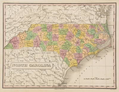
Sold20231860 Mitchell Map of Florida, South and North Carolina -- County Map of Florida on page with Map ofTitle: 1860 Mitchell Map of Florida, South and North Carolina -- County Map of Florida on page with Map of South Carolina, on page with County Map of North Carolina Cartographer: S Mitchell Year / PlaSee Sold Price
Sold2023Anthony Finley North Carolina Counties MapA Anthony Finley (American, 1784-1834) handcolored engraving depicting the counties within North Carolina and the surrounding areas. Stamped 'Published By A. Finley Phliad.' lower center. Presented inSee Sold Price
Sold2018Two Civil War Era Mitchell MapsMap of North America Showing Its Political Divisions and county maps of North Carolina, South Carolina, and Florida on one sheet (Philadelphia: S. Augustus Mitchell, 1860). Not framed. 15.25 x 12.25 iSee Sold Price
Sold2017Mitchell: Antique Map of Florida & South Carolina, 1860Map: 1860 Mitchell Map of Florida and South Carolina -- County Map of Florida [on sheet with] County Map of South Carolina Date Printed: 1860, Philadelphia Cartographer: S Mitchell Size: 9.1 x 10.6 inSee Sold Price
Sold20201860 Mitchell Map of Florida, South and North CarolinaTitle/Content of Map: 1860 Mitchell Map of Florida, South and North Carolina -- County Map of Florida on page with Map of South Carolina, on page with County Map of North Carolina Cartographer: S MitcSee Sold Price
Sold20211860 Mitchell Map of Florida, South and North CarolinaTitle: 1860 Mitchell Map of Florida, South and North Carolina -- County Map of Florida on page with Map of South Carolina, on page with County Map of North Carolina Cartographer: S Mitchell Year / PlaSee Sold Price
Sold20181863 Mitchell Map of Florida, South and North CarolinaTitle/Content of Map: 1863 Mitchell Map of Florida, South and North Carolina -- County Map of Florida on page with Map of South Carolina, on page with County Map of North Carolina Date: 1863, PhiladelSee Sold Price
Sold20181860 Mitchell Map of Florida, South and North CarolinaTitle/Content of Map: 1860 Mitchell Map of Florida, South and North Carolina -- County Map of Florida on page with Map of South Carolina, on page with County Map of North Carolina Date Printed: 1860,See Sold Price
Sold20201860 Mitchell Map of Florida, South and North CarolinaTitle/Content of Map: 1860 Mitchell Map of Florida, South and North Carolina -- County Map of Florida on page with Map of South Carolina, on page with County Map of North Carolina Date: 1860, PhiladelSee Sold Price
Sold20191860 Mitchell Map of Florida and South Carolina --Title/Content of Map: 1860 Mitchell Map of Florida and South Carolina -- County Map Of Florida [on sheet with] Map Of South Carolina Date: 1860, PhiladelphiaCartographer: S Mitchell Size: 10.8 x 13.2See Sold Price
Sold20181867 Mitchell Map of North and South Carolina -- CountyTitle/Content of Map: 1867 Mitchell Map of North and South Carolina -- County Map of North and South Carolina Date: 1867, Philadelphia Cartographer: S Mitchell Size: 11.5 x 13.8 in. This is a handsomeSee Sold Price
Sold20211884 North Carolina MapAuthor: Cram Title: 1884 North Carolina Map Medium: Ink on Paper Dimensions: 14"X11" Rail Road and county Map of North Carolina dated 1884. Printed and published by George Cram in Chicago. Part of hisSee Sold Price
Sold2021Pender County North Carolina mapPender County North Carolina state highway commission map, US Department of commerce Bureau of public roads state wide highway planning survey from January 1, 1961, size is 19“ x 31“ in very goodSee Sold Price
Sold2021New Hanover county North Carolina mapNew Hanover county North Carolina state highway commission map, US Department of commerce Bureau of public roads statewide highway planning survey from January 1, 1961, size, 19“ x 32“ in very gooSee Sold Price
Sold2019Samuel Augustus Mitchell (1790-1868), "County Map ofSamuel Augustus Mitchell (1790-1868), "County Map of Florida, North Carolina, South Carolina," 1860, H. - 12 1/4 in., W. - 15 3/8 in.See Sold Price
Sold2022Scarce early Cram RR map of Southern states“New Railroad and County Map of Alabama, Georgia, South Carolina and North Carolina” from the extremely scarce 1882 edition of Cram’s Unrivaled Family Atlas of the World. This was tSee Sold Price
Sold2017Mitchell Map of Florida, South and North Carolina, 1860Title: 1860 Mitchell Map of Florida, South and North Carolina Cartographer: S Mitchell Published: 1860, Philadelphia Measurements: 10.6 X 13.5 in. County Map of Florida on page with Map of South CarolSee Sold Price
Sold2019Eight (8) Augustus Mitchell MapsCollection of eight maps including New Jersey/Maryland Delaware 1872, Two north and South Carolina 1872 maps (15" x 12"), Minnesota 1890 , Florida and the Carolinas 1860, County map of the state of ArSee Sold Price
Sold20192 Hand Colored Maps - Georgia & South CarolinaTwo Gray's Atlas Maps on one sheet - Georgia and South Carolina Inset of Charleston on South Carolina map. Depicts railroad lines, common roads, canals, topography,See Sold Price
Sold2017Johnson’s Civil War era map of North & South CarolinaHistoric map shows the Carolinas in great detail shortly following the outbreak of the Civil War. States hand-colored at the time of publishing with color coding according to county. Inset map depictsSee Sold Price
Sold2023Map of Maryland, Virginia Texas +Map of South Carolina, Georgia, Florida, Alabama, Mississippi, Louisiana, Tennessee and Arkansas PLUS Maryland, Virginia, West Virginia & North Carolina [1 half sheet side] & Texas [1 half sheet side]See Sold Price
Sold2021Large Map of North Carolina and South CarolinaLarge Map of North Carolina and South Carolina With map of Georgia and Florida[separately] on versos Cartographer: George Franklin Cram Dated: Circa 1900See Sold Price
6 days LeftJasper521896 Cram Map of Virginia, West Virginia, Maryland and Delaware -- Railroad and County Map of$40
6 days LeftJasper521810 Ainslie map of County Renfrew near Glasgow in Scotland -- Map made out for John Wilson ESQ.rs$50
May 16Potter & Potter AuctionsMcCARTY, Lea (1905 – 1960). Sonoma County / Its Highlights ...$100(1 bid)
5 hrs LeftLeland LittleMaud Gatewood (NC, 1934-2004), Maud's Mother with Thomas Day Dresser in Yanceyville$50(1 bid)
May 09Hunt and Peck Estate Services, Inc.ANTONIO ZATTA (ITALIAN, 18TH CENTURY) MAP OF VIRGINIA$80(2 bids)
May 09Hunt and Peck Estate Services, Inc.ANTONIO ZATTA (ITALIAN, 18TH CENTURY) MAP OF VIRGINIA$70(1 bid)
6 days LeftJasper521822 Carey & Lea Map of Massachusetts -- Geographical, Historical, and Statistical Map of$85


![Mitchell: Antique Map of Florida & South Carolina, 1860: Map: 1860 Mitchell Map of Florida and South Carolina -- County Map of Florida [on sheet with] County Map of South Carolina Date Printed: 1860, Philadelphia Cartographer: S Mitchell Size: 9.1 x 10.6 in](https://p1.liveauctioneers.com/5584/109294/56069180_1_x.jpg?height=310&quality=70&version=1505338533)


![1860 Mitchell Map of Florida and South Carolina --: Title/Content of Map: 1860 Mitchell Map of Florida and South Carolina -- County Map Of Florida [on sheet with] Map Of South Carolina Date: 1860, PhiladelphiaCartographer: S Mitchell Size: 10.8 x 13.2](https://p1.liveauctioneers.com/5584/144953/73284299_1_x.jpg?height=310&quality=70&version=1562102885)


![Map of Maryland, Virginia Texas +: Map of South Carolina, Georgia, Florida, Alabama, Mississippi, Louisiana, Tennessee and Arkansas PLUS Maryland, Virginia, West Virginia & North Carolina [1 half sheet side] & Texas [1 half sheet side]](https://p1.liveauctioneers.com/5614/289638/153375966_1_x.jpg?height=310&quality=70&version=1684353133)
![Large Map of North Carolina and South Carolina: Large Map of North Carolina and South Carolina With map of Georgia and Florida[separately] on versos Cartographer: George Franklin Cram Dated: Circa 1900](https://p1.liveauctioneers.com/5614/198722/101907570_1_x.jpg?height=310&quality=70&version=1618847492)


