Sold2020County Map of the State of Texas, 1886Excellent and detailed map of Texas colored by county and showing most of Indian Territory and New Mexico. In this map the Texas counties are still incomplete in the West. Features a large inset planSee Sold Price
Sold2016County Map of the State of Texas 1884Map Title: County Map of the State of Texas Date: 1884 Publisher: WM. M. Bradley & Bro: Philadelphia Size: 14.25 x 21.25 inches Showing also portions of the adjoining states and territories." IncludesSee Sold Price
Sold2017Mitchell: Antique County Map of Texas, 1873Excellent 1873 County Map of Texas by S. Augustus Mitchell. Impressive two-page County Map of the State of Texas. Map image much larger than earlier Mitchell maps. Designed and engraved by W. H. GamblSee Sold Price
Sold20181876 Mitchell Map of Texas -- County Map of the StateReserve Reduced! Title/Content of Map: 1876 Mitchell Map of Texas -- County Map of the State of Texas Showing also portions of the Adjoining States and Territories Date: 1876 Philadelphia CartographerSee Sold Price
Sold2021Pair of Texas Maps and CompassPair of bound Texas Bureau of Economic Geology maps, to include "Atlas of Major Texas Oil Reserves" by Galloway and Ewing, "County Maps of Texas" by the State of Texas, compass 17"h x 22"w/ largest PrSee Sold Price
Sold20191886 California from Mitchell atlasFine antique lithograph map with original hand color. “County Map of the State of California” by William Bradley and found in the 1887 Mitchell New General Atlas. Detailed, scarce and interestingSee Sold Price
Sold2022(TEXAS.) Joseph Hutchins Colton. New Map of the State of Texas Compiled from J. de Cordova's Large(TEXAS.) Joseph Hutchins Colton. New Map of the State of Texas Compiled from J. de Cordova's Large Map. Double-page lithographed map of Texas with attractive original hand-color by county. 18x27 incheSee Sold Price
Sold20191886 Cram Map of Michigan and Wisconsin [verso]Title/Content of Map: 1886 Cram Map of Michigan and Wisconsin [verso] Illinois [verso] State Seals -- Railroad and County Map of Michigan & Wisconsin [verso] Illinois [verso] State Seals of the UnitedSee Sold Price
2017Burgess: Antique Map of the United States, 18531853 Map of the United States with large Texas. Daniel Burgess. Delightful early school atlas map of the region. Shows counties, parishes, towns, rivers, populations, Indian Tribes, Court Houses, FortSee Sold Price
Sold20231866 Schönberg's Early Map of Texas Historic Vintage Inspired Map1866 Schönberg's Early Map of Texas Historic Vintage Inspired Map As settlers spread west, Schönberg's map of Texas shows the growing state of Texas and the contemporary counties as ofSee Sold Price
Sold20221866 Schönberg's Early Map of Texas Historic Vintage Inspired Map1866 Schönberg's Early Map of Texas Historic Vintage Inspired Map As settlers spread west, Schönberg's map of Texas shows the growing state of Texas and the contemporary counties as ofSee Sold Price
Sold2020Scarce hand-colored map of Texas, 1875Attractive and scarce map of Texas with inset map "Western Part of Texas". Exquisite detail with counties painstakingly colored by hand. Interesting map of the growing state developed circa 1875 durinSee Sold Price
Sold2021Map of the Southern States - American Civil WarTitle: Map of the Southern States, Including Rail Roads, County Towns, State Capitals, County Roads, the Southern Coast from Delaware to Texas, Showing the Harbors, Inlets, Forts and Position of BlocSee Sold Price
Sold2023Harper & Brothers, Map of the Southern States, Including Rail Roads, County Towns, State Capitals,Title: Map of the Southern States, Including Rail Roads, County Towns, State Capitals, County Roads, the Southern Coast from Delaware to Texas, Showing the Harbors, Inlets, Forts and Position of BlocSee Sold Price
Sold2024Early Map of North AmericaMap of North America Hand Colored Map. Map showing the Mexico when it contained California and Texas, as well as the United States claim on the west coast stretching to meet the Russian Possessions ofSee Sold Price
Sold2021Scarce variant of Texas, George F. Cram 1883Title: Scarce variant of Texas, George F. Cram 1883 Description: Cerographic relief line engraving with county divisions in yellow and state boundaries outlined in rose. This double-page map is extremSee Sold Price
Sold20221885 Two-page Railroad map of TexasCram’s 1885 double-page railroad map of Texas has exceptional printed color. Every railroad line in the state is highlighted in a heavier black line than such things as county borders, rivers anSee Sold Price
Sold2020Scarce 1883 map of TexasExtremely scarce early 1883 map is different from the more common later 1883 and 1884 version of Cram’s Texas. The later versions have green county borders with rose hachures for the state outline.See Sold Price
Sold2018County Map of Texas.Reserve Reduced! Title: County Map of Texas. Publication Date: 1861 Cartographer: MITCHELL, SAMUEL AUGUSTUS (JR.) Publisher: S. Augustus Mitchell, Jr. Size: 10.75 X 13.25 Map 29 from Mitchell's New GeSee Sold Price
Sold2018County Map of Texas.Title/Content of Map: County Map of Texas. Date Printed: 1870 Cartographer: MITCHELL, SAMUEL AUGUSTUS (JR.) Material/Medium: S. Augustus Mitchell, Jr. Size: 9.25X12 Inset of Galveston Bay and VicinitySee Sold Price
Sold2017Mitchell: County Map of Texas, 1862County Map of Texas, S. Augustus Mitchell, 1862. 10.75 x 13.375 inches. Steel engraved map, with hand colored wash and outlines. Inset map of Galveston Bay, and Vicinity. Colored by county and territoSee Sold Price
Sold2018County Map of Texas, S. A. Mitchell, 1860Reserve Reduced! Authentic handcolored map of Texas with 1860 date but from Mitchell’s New General Atlas published 1864 by S. Augustus Mitchell. Detailed early map of Texas, immediately prior to theSee Sold Price
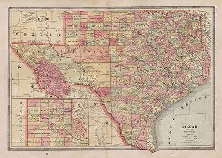
Sold2018Cram: Antique Map of Texas, 1886Title/Content of Map: 1886 Cram Map of Texas / Arkansas and Indian Territory on Verso -- Texas; Arkansas; Indian Ty. Date Printed: 1886, Chicago Cartographer: G Cram Size: 11.8 x 17 in. Handsomely detSee Sold Price
Sold2017Mitchell: Antique County Map of Texas, 1870Map: County Map of Texas Cartographer: S. A. Mitchell Place & Date: Philadelphia / 1870 Size: 13 1/4" x 10 3/4" Condition: full color; light overall age toning The beautifully detailed and colored couSee Sold Price
May 16Potter & Potter AuctionsSTORM, Mark. Official Texas Brags Map of North America. 194...$200(1 bid)
2 days LeftAdam's AuctioneersPLOWDEN, Francis: An Historical Review of The State of Ireland [5 vols.] Philadelphia (William Mc€240(1 bid)
1 day LeftJasper52New Map of That Portion of North America Exhibiting the United States and Territories...Mexico...$360


![1886 Cram Map of Michigan and Wisconsin [verso]: Title/Content of Map: 1886 Cram Map of Michigan and Wisconsin [verso] Illinois [verso] State Seals -- Railroad and County Map of Michigan & Wisconsin [verso] Illinois [verso] State Seals of the United](https://p1.liveauctioneers.com/5584/137769/69881350_1_x.jpg?height=310&quality=70&version=1552435690)


![PLOWDEN, Francis: An Historical Review of The State of Ireland [5 vols.] Philadelphia (William Mc (1 of 4)](https://p1.liveauctioneers.com/533/325941/175488528_1_x.jpg?height=282&quality=70&version=1712845571)


![[SLAVERY] Texas Legal Docket re: Slave Sale (1 of 3)](https://p1.liveauctioneers.com/7226/322253/173251507_1_x.jpg?height=282&quality=70&version=1710004847)
![[SLAVERY] 1854 Texas Slave Hire Document (1 of 1)](https://p1.liveauctioneers.com/7226/322253/173251505_1_x.jpg?height=282&quality=70&version=1710004847)