Sold2023Two Maps, Africa by Eustache Herisson, 1809, World Hemispheres 1832 Reprint after A.H Brue, GermanDescription: An antique Africa map, in French and dated 1809 by Eustache Herisson, and a reprit of an early 19th century map of World Hemispheres by Adrien-Hubert Brue. Type: MapMaterials: PaperMarkinSee Sold Price
Sold2023Gross, Alexander 1920 Lot of 6 Large Maps. Africa & AsiaIncl Asia Political, Asia Physical, Indian Ocean, Africa Physical, Africa North-West, Africa West Coast. Large Lithograph Maps Published 1920, London for "The Daily Telegraph Victory Atlas of the WorlSee Sold Price
Sold20221738 Geography ATLAS 16 Maps Africa Italy Asia Buffier Poland Ottoman Turkey1738 Geography ATLAS 16 Maps Africa Italy Asia Buffier Poland Ottoman Turkey Known primarily for his contributions to philosophy, Claude Buffier, a 17th-century French Jesuit historian, published a woSee Sold Price
Sold20241690 Danckerts Map of Africa -- Novissima et Perfectissima Africae DescriptioTitle: 1690 Danckerts Map of Africa -- Novissima et Perfectissima Africae Descriptio Cartographer: J Danckerts Year / Place: 1690 c., Amsterdam Map Dimension (in.): 19.2 X 22.7 in. This is an attractiSee Sold Price
Sold20211796 RARE Morse American ATLAS Geography MAPS Africa1796 RARE Morse American ATLAS Geography MAPS Africa France Asia Holy Land Jedidiah Morse was an important and prominent geographer known for his American textbooks, books that earned him the name fatSee Sold Price
Sold20201711 MAPS Atlas Geography Africa Asia America1711 MAPS Atlas Geography Africa Asia America California Island France Buffier Claude Buffier was a 17th-century French historian who published works on metaphysics, grammar, and, most notably, univerSee Sold Price
Sold20201759 Geography 18 Maps ATLAS Africa Italy Asia America1759 Geography 18 Maps ATLAS Africa Italy Asia America California Island Buffier Known primarily for his contributions to philosophy, Claude Buffier, a 17th-century French Jesuit historian, publishedSee Sold Price
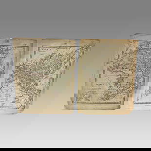
Sold2023Lot of 2 Africa, Asia Maps 1808-1809. Size 13 1/2 x 10 1/2 inches lengthLot of 2 Africa, Asia Maps 1808-1809. Size 13 1/2 x 10 1/2 inches length. The map shows Africa way before the infamous expedition by John Hanning Speke to the source of the Nile.See Sold Price
Sold2015EUROPAE. [Ortelius, Ca. 1584-1612.] Map.[Ortelius, Abraham] EUROPAE. [C. 1584-1612.] Engraved map by Ortelius based on Jenkinson’s Russia map and Gastaldi’s maps of Africa and Asia, Gerard Mercator’s 1564 map of Britain, a map of ScanSee Sold Price
Sold20171807 William Guthrie French ATLAS Illustrated MAPS1807 William Guthrie French ATLAS Illustrated MAPS Asia Africa France America Originally translated into French in 1801, William Guthrie’s “Geographical, Historical and Commercial Grammar’, hasSee Sold Price
Sold2015De Bry (Theodore) - Descriptio Hydrographicathe 2-sheet map of Africa and Asia, from the east coast of Brazil to Japan, charting the first Dutch voyage to the East Indies by Houtman, large titlecartouche upper centre of right sheet, ships, compSee Sold Price
Sold2021Ca 1720 Homann Map of AfricaCa 1720 Johan Baptiste Homann (German 1664-1724) "Totius Africae Nova Representatio" hand colored two sheet map of Africa, plate size 19" x 22", well framed, overall size 23 1/2" x 27"See Sold Price
Sold20201734 ATLAS Vaugondy MAPS Geography Asia Africa Europe1734 ATLAS Vaugondy MAPS Geography Asia Africa Europe USA France Germany Collectors, of both maps and atlases, agree that Vaugondy maps are among the best and most accurate maps! The collection of 18tSee Sold Price
Sold20181780 VOYAGES 17 ATLAS Maps Geography Asia Africa Europe1780 VOYAGES 17 ATLAS Maps Geography Asia Africa Europe USA Vaugondy Collectors, of both maps and atlases, agree that Vaugondy maps are among the very best and most accurate maps! This collection of 1See Sold Price
Sold20201780 VOYAGES 17 ATLAS Maps Geography Asia Africa Europe1780 VOYAGES 17 ATLAS Maps Geography Asia Africa Europe USA Vaugondy Collectors, of both maps and atlases, agree that Vaugondy maps are among the best and most accurate maps! This collection of 18th-cSee Sold Price
Sold20191780 VOYAGES 17 ATLAS Maps Geography Asia Africa Europe1780 VOYAGES 17 ATLAS Maps Geography Asia Africa Europe USA Vaugondy Collectors, of both maps and atlases, agree that Vaugondy maps are among the very best and most accurate maps! This collection of 1See Sold Price
Sold20191770 VOYAGES 17 ATLAS Maps Jesuits Asia Africa Europe1770 VOYAGES 17 ATLAS Maps Jesuits Asia Africa Europe USA Astronomy Geography An early printing of a rare geographic atlas filled with 17 folding maps! We do not find any other examples of this same eSee Sold Price
Sold2024Two Framed Maps Of Europe & AsiaTwo Framed Maps Of Europe & Asia. As framed approximately 28.75W x 24.25H in. 26.25W x 22.75H in.See Sold Price
Sold2019Goldsmith 1842 Group of 3 Maps. Europe, Asia, AfricaSteel Engraved Maps Published 1842, London for "Goldsmith's Grammar of Geography" by W. S. Kenny and the Rev. Goldsmith. Folds as issued. Paper Size: 7.5 x 6 inch (19 x 15cm) One with minor toning. TiSee Sold Price
Sold20181770 VOYAGES Geography 17 ATLAS Maps Jesuits Asia Afric1770 VOYAGES Geography 17 ATLAS Maps Jesuits Asia Africa Europe USA Astronomy Collectors, of both maps and atlases, agree that Vaugondy maps are among the very best and most accurate maps! This collecSee Sold Price
Sold2019Ortelius, two historicalOrtelius, two historical maps of North Africa and Austria from the ''Theatrum Orbis Terrarum'' around 1580, ''Barbariae et Biledulgerid nova descriptio'' and ''Austriae Ducatus Chorographia ...'', altSee Sold Price
Sold20211886 Classical Atlas Rome Greece HOMER Odyssey Africa1886 Classical Atlas Rome Greece HOMER Odyssey Africa Asia Illustrated MAPS Rare Ginn Company’s Classical Atlas is a collection of 23 colored maps added to the ‘School and College Atlas of AncientSee Sold Price
Sold2020Grp: 12 Regional Maps of AfricaGroup of twelve 18th and 19th c. regional maps of Africa. Includes two maps of the North African coast; one map of Madagascar; one page with seven inset maps of the major islands of Africa; one map ofSee Sold Price
Jul 16BADO e MART AUCTIONSAsia and Africa Maps. HERISSON. Carte générale de l’Afrique & Carte géné€250
4 days LeftNY Elizabeth ANTIQUE MAP-ILLUSTRATED FLORAL ILLUSTRATION 1761 NEW DICTIONARY OF TRADE AND COMMERCE R. ROTH$100
6 days LeftTrillium Antique Prints & Rare BooksPrevost - Chart of the lower Atlantic Ocean and Indian Ocean with Africa, part of South America,$75
19 hrs LeftRapid Estate Liquidators and Auction GalleryHarry Potter Interactive Oak & Hazel Wands Universal Studios$35
Jul 04Weatherham Estate Treasures6" x 6" Framed Male Two-Spot Blue Charaxes Butterfly - Charaxes Bipunctatus$74
6 days LeftTrillium Antique Prints & Rare BooksPrevost - Chart of the South Pacific Ocean with part of New Holland (Australia), New Zealand, and$75
6 days LeftTrillium Antique Prints & Rare BooksPrevost - 5 Botanical or Flora Engravings (Banana, Mango, Pineapple, Papaya, Coconut)$75
6 days LeftTrillium Antique Prints & Rare BooksPrevost - Chart of the Pacific Ocean with part of the Americas, China, and New Holland (Australia)$75
Jul 06Case Antiques, Inc. Auctions & AppraisalsColton's Atlas of the World, 1856, in Two Volumes; plus Africa / Mahdist War Map$500(1 bid)
4 days LeftJulien's AuctionsDuke of Kent | 1900 Commemorative Linen Scarf With South Africa Map And Poem$50
2 days LeftFreeman's | Hindman[Travel & Exploration] Bowdich, T. Edward: Mission from Cape Coast Castle to Ashantee...$250


![EUROPAE. [Ortelius, Ca. 1584-1612.] Map.: [Ortelius, Abraham] EUROPAE. [C. 1584-1612.] Engraved map by Ortelius based on Jenkinson’s Russia map and Gastaldi’s maps of Africa and Asia, Gerard Mercator’s 1564 map of Britain, a map of Scan](https://p1.liveauctioneers.com/179/82189/42599765_1_x.jpg?height=310&quality=70&version=1447864785)


![[Travel & Exploration] Stanley, Henry M.: In Darkest Africa... (1 of 5)](https://p1.liveauctioneers.com/65/332523/179335288_1_x.jpg?height=282&quality=70&version=1717622830)


![[Travel & Exploration] Bowdich, T. Edward: Mission from Cape Coast Castle to Ashantee... (1 of 3)](https://p1.liveauctioneers.com/65/332523/179335283_1_x.jpg?height=282&quality=70&version=1717709446)