Sold2020Plan of New Haven, Connecticutby Amos Doolittle 30" x 37 1/2" overall including details of Yale University 1824See Sold Price
Sold2016Map of the States of Virginia, North Carolina...Jedidiah Morse (1761-1826), Engraved by Amos Doolittle. New Haven: Doolittle, 1788. Engraved Map. 13 1/2 x 15 1/4 inches paper size.See Sold Price
Sold20151867 Map of California and NevadaLeander Ransom & Amos Doolittle: A New Map of the States of California and Nevada, Exhibiting the Rivers, Lakes, Bays and Islands, with the principal Towns, Roads, Railroads and Transit Routes to theSee Sold Price
Sold2022PURCELL, JOSEPH A Map of the States of Virginia North Carolina South Carolina and GeorgiaPURCELL, JOSEPH A Map of the States of Virginia North Carolina South Carolina and Georgia Comprehending the Spanish Provinces of East and West Florida... New Haven: Amos Doolittle, 1788. Engraved mapSee Sold Price
Sold'Federal Hall: The Seat of Congress' Facsimile Engraving, Charles A.G. Swasey (publisher), New ...'Federal Hall: The Seat of Congress' Facsimile Engraving, Charles A.G. Swasey (publisher), New Bedford, Massachusetts, 1903, after Amos Doolittle (American, 1754-1832). The 13 x 16 1/2-inch print depiSee Sold Price
2021Amos Doolittle THE BATTLES OF LEXINGTON AND CONCORD INAmos Doolittle (1754-1832) THE BATTLES OF LEXINGTON AND CONCORD IN 1775 Four hand-colored reproduction prints, framed. Sight of sheets approximately 10 1/2 x 13 1/2 inches C Property from The Monroe aSee Sold Price
Sold2020Amos Doolittle Map of ConnecticutAmos Doolittle Map of Connecticut. Map: H 12", W 14-1/2" approx; frame size: H 20-1/4",. W 22-1/2". Professionally framed. Collection of Laura Mitler. Please see link for high res photos: https://www.See Sold Price
Sold2017Map of the States of New Hampshire & VermontCirca 1796 Antique Map Title: "Map of the States of New Hampshire and Vermont". Citation: by J. Denison. Amos Doolittle, Sculp. Approximate size: 10-3/8" x 8-3/8". Please note that this lot has a confSee Sold Price
Sold2020LEGO Collector Set #10184 Town Plan New and UnopenedLEGO Collector Set #10184 Town Plan New and Unopened: Incredible LEGO collector set. All of the LEGO sets in the auction are from a single home, high end collector of LEGO's. These are all unopened boSee Sold Price
Sold2024Bev Doolittle New Magic & Western Am. ArtMasterpieces of Western American Art by J Gray Sweeney, Mallard Press, 1991, includes dust jacket, first edition. Bev Doolittle New Magic by Elise Maclay, published by the Greenwish Workshop, 1995, FiSee Sold Price
Sold2023BELLIN, JACQUES-NICOLAS. Two eighteenth-century engraved city plans (New York and Philadelphia) fromBELLIN, JACQUES-NICOLAS. Two eighteenth-century engraved city plans (New York and Philadelphia) from Le Petit Atlas Maritime. 12½x9½ inches each sheet size, wide margins; original hand-colorSee Sold Price
Sold20201928 New York Map of Graphic Region Plan1928 New York Cartograph of Graphic Region Plan, New York and its Environs, committee member names also listed below 1928. Made by Williams and Heintz and Company, Washington DC. Depicting parts of thSee Sold Price
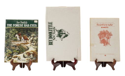
Sold2022Set of (3) Bev Doolittle Reference BooksSet of three Bev Doolittle reference books, to include "The Forest has Eyes", "Bev Doolittle: New Magic" and "The Earth is my Mother" by Bev Doolittle height 15.5 in. x widthSee Sold Price
Sold2017Rand McNally: Antique City Plan of Brooklyn, NY, 1912Title/Content of Map: 'Main Portion Brooklyn ' Brooklyn town city map plan. New York. Date Printed: 1912 Image Size: Approx 27.5 x 33.5cm, 10.75 x 13 inches (Large) Type: Antique colour (color) city pSee Sold Price
Sold2022Group of 9 Assorted Cruise EphemeraIncludes Vulcania Passenger Plan, New York Cruise Plan, and more.See Sold Price
Sold2021Reproduction Map, 1777, City and Environs of PhilaA 1969 reproduction map of the 1777 example, "The City and Environs of Philadelphia" on laid paper and published by the Historic Urban Plans, New York. Dimensions: The frame is 32" x 25". Provenance:See Sold Price
Sold2017First printed plan of New Haven, showing Yale CollegeA plan of the town of New Haven : with all the buildings in 1748...William Lyon (fl. c. 1800-1806). Engraved map. New Haven: T. Kensett, 1806. 28 1/4 x 20 1/2 inches sheet. The Kensett map is the firsSee Sold Price
Sold2022(NEW ORLEANS.) Benjamin Moore Norman. Norman's Plan of New Orleans & Environs.(NEW ORLEANS.) Benjamin Moore Norman. Norman's Plan of New Orleans & Environs. Finely detailed hand-colored engraved pocket map of New Orleans with an 86-point keyed reference panel. 17¾x24½See Sold Price
Sold20221903 The Battle of Lexington After Amos DoolittleAmerican Revolution Scarce 1903 Charles E. Goodspeed after Amos Doolittle Engraving titled "A View of the South Part of Lexington" 1903-Dated, Rare Limited Edition, No. 56 of 75 only and the plate desSee Sold Price
Sold2017Napoleonic Print by Amos DoolittleBonaparte in Trouble. Amos Doolittle (1754-1832). Hand-colored engraving on laid paper. Connecticut: Shelton & Kensett, Cheshire, c. 1814. 10 1/2 x 14 1/2 inches visible, 17 3/4 x 21 1/4 inches framedSee Sold Price
Sold2022AMOS DOOLITTLE Engraved JOHN WINTHROP PortraitColonial America "The Honorable JOHN WINTHROP, Esq." Original Historic Amos Doolittle Engraved Copper Plate Portrait (AMOS DOOLITTLE) (1754-1832), American Revolutionary War Patriot, Colonial Artist aSee Sold Price
Sold2022FATHER ABRAHAM'S ALMANAC, [ON AN ENTIRE NEW PLAN] FOR THE YEAR OF OUR LORD, 1760ABRAHAM WEATHERWISE, GENT. FATHER ABRAHAM'S ALMANAC, [ON AN ENTIRE NEW PLAN] FOR THE YEAR OF OUR LORD, 1760... (Philadelphia: W. Dunlap, Printed and sold by W. Dunlap, at the newest-printing-office, iSee Sold Price
Sold2021TWO FRENCH LOUIS XV AND LOUIS XVI PLANS OF NEW ORLEANS,TWO FRENCH LOUIS XV AND LOUIS XVI PLANS OF NEW ORLEANS, "Nouvelle Orléans Capitale de la Louisiane.," AND, "Plan de La Nouvelle Orléans," 1758-1780, comprising two engravings on paper, "NOUVELLE ORLSee Sold Price
Sold2022c 1800 AMOS DOOLITTLE Engraved Print Israel KingJudaica "Ahab, King of Israel, Slain in his Chariot" Engraved Print from Maynard's "Josephus" by Amos Doolittle c. 1800, "Ahab, King of Israel, Slain in his Chariot by an Arrow at the Battle of RamothSee Sold Price
9 hrs LeftJasper521874 Holmes Plan of New York's Upper East Side -- Map of the Common Lands from 76th to 93rd Street$750
2 days LeftSwann Auction Galleries(VIETNAM WAR.) Here's My New 8-Point Plan for Peace . . . U.S. Out of Southeast Asia Now!$450
Featured1 day LeftJasper52Bahamas. Turks & Caicos. New Providence. Nassau plan. 53x67cm. STANFORD 1896 map$360
Freeman's | Hindman[MAPS - LOUISIANA - WAR OF 1812]. Maps of Louisiana, incl. Battle of New Orleans battle site map.$150(1 bid)
1 day LeftEmanon Auctions and Estate SalesGeneral plan of the railroad tracks for new york and its enviroms 1928 21.5x20$5
1 day LeftEmanon Auctions and Estate SalesGeneral plan of the park system for new york and its enviroms 1928 21.5x20$5
1 day LeftEmanon Auctions and Estate SalesGeneral plan of the highway system for new york and its enviroms 1928 21.5x20$5
1 day LeftEmanon Auctions and Estate SalesGeneral plan of the land uses for new york and its enviroms 1928 21.5x20$5
2 days LeftSwann Auction Galleries(JUDAICA--HOLY LAND.) Issue of the Yiddish-language "Forward" on the new "Jewish Kingdom" and$750
2 days LeftSwann Auction Galleries(COLONIAL WARS.) Plan and description of the fortifications at Crown Point, a very early newspaper$450
2 days LeftMynt AuctionsChristian Dior LADY D-LITE Medium Handbag Plan de Paris Embroidery M0565OOMP_M993 Cotton Made in$5
2 days LeftSwann Auction Galleries[ABRAHAM LINCOLN.] Edward Everett. An Oration Delivered on the Battlefield of Gettysburg.$6,000
2 days LeftRail & Road AuctionsTwenty Norfolk Southern Railroad Promotional Items and Employee Handbooks$30


![FATHER ABRAHAM'S ALMANAC, [ON AN ENTIRE NEW PLAN] FOR THE YEAR OF OUR LORD, 1760: ABRAHAM WEATHERWISE, GENT. FATHER ABRAHAM'S ALMANAC, [ON AN ENTIRE NEW PLAN] FOR THE YEAR OF OUR LORD, 1760... (Philadelphia: W. Dunlap, Printed and sold by W. Dunlap, at the newest-printing-office, i](https://p1.liveauctioneers.com/394/255490/133049085_4_x.jpg?height=310&quality=70&version=1658512482)


![[MAPS - LOUISIANA - WAR OF 1812]. Maps of Louisiana, incl. Battle of New Orleans battle site map. (1 of 7)](https://p1.liveauctioneers.com/197/333931/180433328_1_x.jpg?height=282&quality=70&version=1719251353)


![[ABRAHAM LINCOLN.] Edward Everett. An Oration Delivered on the Battlefield of Gettysburg. (1 of 2)](https://p1.liveauctioneers.com/199/334052/180497939_1_x.jpg?height=282&quality=70&version=1718909401)

