Sold2022Early Framed Map of Troy, NY 1802 15"x18"Early Framed Map of Troy, NY 1802 15"x18"See Sold Price
Sold2021EARLY URSA MAJOR CONSTELLATION MAP, FRAMED, FROM OLDEARLY URSA MAJOR CONSTELLATION MAP, FRAMED, FROM OLD ESTATE IN WOODSTOCK, N.Y. HAS AGE FOXING, BUT STILL WONDERFULLY ILLUSTRATED. MEASURES 12.5" X 15.5".See Sold Price
Sold2018Flemish 17th Century Drawing of Ruins Ink on PaperFlemish 17th Century Drawing of Ruins Ink on Paper 7''x11'' Sight. An early Renaissance era image of a landscape with classical ruins. Unsigned. Gallery framed 15''x18''. Excellent condition.See Sold Price
Sold2021Antique Framed Map Livingston,Germantown,Claremont NYAntique Framed Map of Livingston, Germantown and Claremont, Columbia County, NY. Dated 1850. Engraved by R.H.Pease, Albany, NY. Lovely early map is nicely framed in dark brown wood, and wired on the bSee Sold Price
Sold2021EARLY FRAMED NYC MAP, PART OF WARD 9, NEW YORK CITYEARLY FRAMED NYC MAP, PART OF WARD 9, NEW YORK CITY PART OF SECTION 2, FRAMED AND MATTED, MAKER OR DATE UNKNOWN. MAP MEASURES 23" X 32". IN VERY NICE ESTATE CONDITION, FROM WOODSTOCK, N.Y. ESTATE.See Sold Price
Sold2023Group of 4 Early European MapsGroup of 4 early framed European maps, including; 'De L'Europe, figure III., Isle D'Albion", 'Westmorland', 'Wien in Oesterreich' and 'Milan'. Measures: 12" x 15 1/2" overall, largest.See Sold Price
Sold2021Antique Framed Map of Livingston Manor, NY, dated 1714Antique Framed Map of Livingston Manor, NY, dated 1714. Engraved by J.E. Gavit, Albany, NY. Lovely early map is nicely framed in dark brown wood, matted in white, and wired on the back and ready to haSee Sold Price
Sold2015Harrison Begay, Navajo ( ? )Early 1970s, Outstanding watercolor of a classic scene titled "Young Roper & His Dog," matted and framed. 15" x 10" (22" x18" framed)See Sold Price
Sold2022Early 19th Century Map of the West IndiesMap titled "West Indies On Mercators Projection" published by Thomas Kelly, No. 53 Paternoster Row, London in 1815. Framed map measures 10.5" x 15.75" (sight) and is housed in frame measuring 20" x 25See Sold Price
Sold2017Three framed local maps including Dutchess County NY,Three framed local maps including Dutchess County NY, Putnam County NY, and a hand colored City of Poughkeepsie. All in good condition, late 19th to early 20th century.See Sold Price
Sold2017Two(2) Early Hand Colored MapsTwo(2) framed hand colored maps. Cornwall and Dorsetshyre; 15.5in. X 20.25in.See Sold Price
Sold2015Oil on Tin, "The Kiss"Early framed painting on tin depicting two males and one female figure, "The Kiss". [Art: 12" x 15"; Frame: 21 1/4" x 24 1/4"]. Paint loss, craquelure.See Sold Price
Sold2017Antique Map "Siciliae Veterisiypus"Framed map, dated 1696. Dimensions: Map- - Sight: 15" H x 20" W; Frame: 23.75" H x 27.75" W; See Sold Price
Sold2016Orcutt, Humiston Stoneware Jug Troy NYEarly 19th century, two-gallon, tall ovoid stoneware jug with flattened collar, applied strap handle, stamped on the shoulder "ORCUTT HUMISTON & CO TROY 2" with cobalt floral spray, 15" H. Condition -See Sold Price
Sold2022John SPEED: Two Antique Maps of IrelandTwo framed antique maps of Ireland by John Speed, a well known English cartographers circa 17th century. [Maps: 15" H x 20" W; Frames: 24" H x 28 1/2" W].See Sold Price
Sold2018EARLY HANDCOLORED MAP JUDAE FEU TERRA ISRAELIS, FROMEARLY HANDCOLORED MAP JUDAE FEU TERRA ISRAELIS, FROM EARLY ATLAS, FRAMED WHERE YOU CAN SEE BOTH SIDES IN GLASS, MEASURES 15 1/2" X 19 1/2". WATER STAIN IN LOWER RIGHT CORNER. FROM A GROUP WE ARE SELLISee Sold Price
Sold2024Early Pawling N.Y. Green Family LettersLot (2) framed 19th c. Green family Pawling N.Y. letters. Largest frame 15 1/2" x 11".See Sold Price
Sold2020(3 Pc) Framed Vintage MapsDESCRIPTION: A lot of three vintage maps depicts Asia, Africa and the Mediterranean. Provenance: Purchased from Neville Sargent Gallery CIRCA: Early - Mid 20th Cent. DIMENSIONS: H: 15" W: 18" CONDITIOSee Sold Price
Sold2023Antique Map of HispaniolaAntique Map of Hispaniola, "Hispaniolae, Cubae...", Ortelius, late 17th/early 18th c., hand-colored engraved map, sight 15 in. x 21 1/2 in., framedSee Sold Price
Sold2022A FRAMED ANTIQUE CHINESE MAP ON PAPERColor and ink on paper, the map depicting the area south of great wall of china, also including korea, parts of Japan, and Vietnam Early Qing Dynasty period. Height: 18 1/2 in (47.0 cm) Width: 15 in (See Sold Price
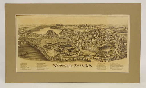
Sold2022Wappingers Falls New York Large ViewWappingers Falls, N.Y. Large Panorama Bird's-eye Map. L.R. Burleigh, Troy, New York, c. 1889. Antique print. 15" x 29".See Sold Price
Sold2015Chez Pierre Vander, "Nouvelle France," MapChez Pierre Vander, "Nouvelle France," hand colored early map of Canada, matted and framed, 10" h x 15" w (view), 15 1/2" h x 20" w (frame). Provenance: From a Massachusetts estate.See Sold Price
2 days LeftTremont Auctions18th century map "Americae Septentrion" by Homann. Rarer early edition. Framed. Holes around outer$250(1 bid)
May 16Eldred'sAMERICAN SCHOOL (Early 20th Century,), Road into town., Oil on canvas, 15" x 9.5". Framed 17" x$50(1 bid)
May 16Eldred'sAMERICAN SCHOOL (Early 20th Century,), Lush landscape., Oil on artist board, 10" x 14". Framed$80(2 bids)
4 days LeftHudson Valley Auctioneers LLC Beacon NYSilver tray, marked 835 with a horse mark, tray is 15.5" by 19.5", 44 troy$750(3 bids)
3 days LeftCurated Gallery AuctionsFrederick Kost 1861-1923 Antique American Impressionist Long Island Grazing Cows Framed Oil Painting$120(3 bids)


![Oil on Tin, "The Kiss": Early framed painting on tin depicting two males and one female figure, "The Kiss". [Art: 12" x 15"; Frame: 21 1/4" x 24 1/4"]. Paint loss, craquelure.](https://p1.liveauctioneers.com/1221/82182/42947181_1_x.jpg?height=310&quality=70&version=1447857677)


![John SPEED: Two Antique Maps of Ireland: Two framed antique maps of Ireland by John Speed, a well known English cartographers circa 17th century. [Maps: 15" H x 20" W; Frames: 24" H x 28 1/2" W].](https://p1.liveauctioneers.com/1221/264089/138965458_1_x.jpg?height=310&quality=70&version=1667576821)