Sold2022Early Hand Drawn Map of United States in 1817,by Mary Young, image area 20" X 30" plus frame.See Sold Price
Sold2021Artwork LotLot including early hand drawn maps (largest 14" x 16"), floral watercolor (20" x 12 3/4"), painting on panel marked LRC "LT Keeler Kimpo Korea '53" (12 1/4" x 16 1/4").See Sold Price
Sold2023Loaded Lot of Early Advertising Therms, Hand Drawn Maps, Farm Dealer Manuals and MoreThis lot is loaded with early advertising including Fordson, International, John Deere and MoreSee Sold Price
Sold20171853 Hand Drawn Map Sumter District South Carolinadrawn on what appears to be a handkerchief or piece of linen by Samuel N. Atkinson surveyor, at the request of M.E. Dixon. map depicts 751 acres and includes borders with Middleton Plantation and theSee Sold Price
Sold202219th Century Hand-Drawn Map of NY, PA, MD, NJ, DEHistoric Maps 19th Century Original Hand-Drawn Regional Map of New York, Pennsylvania, Maryland, New Jersey, and Delaware 19th Century Hand-Drawn Regional Map of New York, Pennsylvania, Maryland, NewSee Sold Price
Sold2022[MANUSCRIPT MAP-MAINE] After DES BARRES, JOSEPH FREDERICK WALLET. Hand-drawn map of a portion of the[MANUSCRIPT MAP-MAINE] After DES BARRES, JOSEPH FREDERICK WALLET. Hand-drawn map of a portion of the Maine coast off Falmouth, copied from Des Barres. Likely early 19th century. Manuscript map in blacSee Sold Price
Sold20171815 South Carolina Land Survey & 1829 DeedPen & ink, hand drawn survey map with coloring, dated July 28, 1815 describing 211 acres on Tiger River in Union District belonging to William Linam, William Lucas and heirs of Jeremiah Hamilton, Esq.See Sold Price
Sold2020Early 19th Century Map of VermontHAND DRAWN, COLORED MAP OF VERMONT BY ESTHER CONKEY OF ORWELL OCT 22 1825 ON PAPER 21"X17" LINEN BACKED TORN THRU CENTER OF MAP WITH SOME LOSSES, TAPE RESIDUE,TONING AND SPOTTING - IMPERFECTIONSee Sold Price
Sold2015EARLY MAPS OF SKOWHEGAN AND MADISON, MAINEEARLY MAPS OF SKOWHEGAN AND MADISON, MAINE Early hand-drawn and colored map of Skowhegan, Maine, 15 1/2" x 12 1/2", a copy of a 1790 map executed in Boston, Feb. 2, 1791and showing the Kennebec and SaSee Sold Price
Sold2017Two Vintage Hand Drawn Timber Crew Maps of Kershaw1974. hand drawn in good detail by Sho Morrison. maps depict the Ramsey home site in Boykin, South Carolina and give detail of tree growth on pine plantation and borders. H11 3/4" W17 3/8"See Sold Price
Sold2022ANTIQUE MAPS, 3 PCS, H 6.25"-14.75", CHARLESTON, SAVANNAH & YORKSHIREANTIQUE MAPS, 3 PCS, H 6.25"-14.75", CHARLESTON, SAVANNAH & YORKSHIRE A selection of three antique maps. Includes one hand-colored 'Parts of North and South Carolina' coastal map (H 14.75" x W 13"), oSee Sold Price
Sold2021LATE 19TH & EARLY 20TH C. KANSAS MAPS LOT OF 6LATE 19TH & EARLY 20TH C. KANSAS MAPS LOT OF 6 Lot of late 19th and early 20th century maps of Kansas. Includes 5 Hand drawn and hand colored maps from the 1880s. Fort Scott, Eldorado, Emporia, SalinSee Sold Price
Sold2019Balkans.- Adriatic Sea .- Ruscelli (Girolamo) TavolaBalkans.- Adriatic Sea .- Ruscelli (Girolamo) Tavola Nuova di Schiavonia, map covering the Adriatic coastal region of the Balkans, engraving with early hand-colouring on laid paper with indistinct cirSee Sold Price
Sold2022(ON-19) EARLY TRAIL OF TEARS EPHEMERA DOCUMENTS CHOCTAW NATIONEarly 19th collection of documents that includes two maps. The group with no odors and in clean condition. 1) A map with cover note that is hand drawn and lightly colored showing vacant landsaround deSee Sold Price
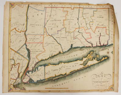
Sold2023EARLY CONNECTICUT MAPHand drawn and colored; "Connecticut and Parts Adjacent", "drawn by Miss. Elizabeth L. Tredwell" "Christ Church Academy 1820", several edge tears; 23" x 30", F-GSee Sold Price
Sold2023F. Gray's Idaho, Montana and Wyoming Map 1870Featured in this lot is an excellent, hand-colored early map of Idaho Territory, Wyoming Territory and Montana Territory, published by O.W. Gray and drawn by Frank A. Gray. Wyoming is shown with onlySee Sold Price
Sold2022Scarce early Cram RR map of North CarolinaDesirable and scarce railroad map of North Carolina from a very scarce and early Cram atlas. The 1882 edition of Cram’s Unrivaled Family Atlas of the World was the last Cram atlas to use hand cSee Sold Price
Sold2023Early 1900's Railway Mail Service Map, Virgina, North CarolinaDated 1910, hand-colored Third Division Railway Mail Service map, showing railway mail service lines in West Virginia, Virginia & North Carolina. Engraver: Fisk, E. F. Cartographer: International CorrSee Sold Price
Sold20222 PC. FRAMED EARLY ENGLISH MAPS2 PC. FRAMED EARLY ENGLISH MAPS: Comprising; 1- Hand-colored Oxford Shire map, by Robert Morden. 1- An accurate map of the county of Bedford divided into its hundreds. Drawn from a late survey, & illuSee Sold Price
Sold2023Early Map of Tennessee, Daniel Smith, 1795A MAP OF THE TENNASSEE [sic] GOVERNMENT FORMERLY PART OF NORTH CAROLINA TAKEN CHIEFLY FROM SURVEYS BY GENL. D. SMITH & OTHERS, drawn by Daniel Smith, engraved by Joseph T. Scott, for "General Atlas FoSee Sold Price
Sold2019Early map of San Francisco - 1853Reserve Reduced! Rare, hand-colored coastal chart of San Francisco and part of the Bay, with soundings. Extends to the Mission de Dolores and Pt. San Quentin. Shows street layout, buildings, wharfs, rSee Sold Price
Sold2017THOMAS HART BENTON LETTER, HAND DRAWN MAP, ETCAutographs, drawing, photos and ephemera from the estate of Kansas City writer and photographer Bob Barrett (1943- 2016) relating to his personal experience with Kansas City artist Thomas Hart BentonSee Sold Price
Sold2017HAND DRAWN MAP OF "HARDENBURGH PATENT GRANTED INYEAR 1704" COMPILED & LAID DOWN FROM ACTUAL SURVEY (47" X 57 1/2")See Sold Price
Sold2017Hand drawn map of the world, Eastern and WesternHand drawn map of the world, Eastern and Western Hemisphere, executed by Marta Maxwell August 13, Lebanon, August 31, 1814. sight size: 16" x 21 1/2"See Sold Price


![[MANUSCRIPT MAP-MAINE] After DES BARRES, JOSEPH FREDERICK WALLET. Hand-drawn map of a portion of the: [MANUSCRIPT MAP-MAINE] After DES BARRES, JOSEPH FREDERICK WALLET. Hand-drawn map of a portion of the Maine coast off Falmouth, copied from Des Barres. Likely early 19th century. Manuscript map in blac](https://p1.liveauctioneers.com/292/250642/130213649_1_x.jpg?height=310&quality=70&version=1654271664)


![Early Map of Tennessee, Daniel Smith, 1795: A MAP OF THE TENNASSEE [sic] GOVERNMENT FORMERLY PART OF NORTH CAROLINA TAKEN CHIEFLY FROM SURVEYS BY GENL. D. SMITH & OTHERS, drawn by Daniel Smith, engraved by Joseph T. Scott, for "General Atlas Fo](https://p1.liveauctioneers.com/525/272425/142901899_1_x.jpg?height=310&quality=70&version=1671337478)


