Sold2023Early 1900's Railway Mail Service Map, Virgina, North CarolinaDated 1910, hand-colored Third Division Railway Mail Service map, showing railway mail service lines in West Virginia, Virginia & North Carolina. Engraver: Fisk, E. F. Cartographer: International CorrSee Sold Price
Sold2020A COLLECTION OF EARLY 1900s SOUTHERN RAILWAY MAPS ETCThirty-three items include brochures, maps and company correspondence. We happily provide seamless in-house packing and shipping services on nearly everything we sell.See Sold Price
Sold2022Scarce early Cram RR map of North CarolinaDesirable and scarce railroad map of North Carolina from a very scarce and early Cram atlas. The 1882 edition of Cram’s Unrivaled Family Atlas of the World was the last Cram atlas to use hand cSee Sold Price
Sold2022Early 1847 school atlas map of East Coast statesEarly map of Maryland, Virginia, North Carolina and Delaware from Smith’s Quarto Geography published 1848 by Cady & Burgess. Very few railroad lines shown, as the industry was still in its infanSee Sold Price
Sold2019North & South Carolina Early MapJohnson's North Carolina and South Carolina. Antique Map. A.J. Johnson, New York, c. 1866-70.. 18" x 26 1/2".See Sold Price
Sold2023Early Map of Tennessee, Daniel Smith, 1795A MAP OF THE TENNASSEE [sic] GOVERNMENT FORMERLY PART OF NORTH CAROLINA TAKEN CHIEFLY FROM SURVEYS BY GENL. D. SMITH & OTHERS, drawn by Daniel Smith, engraved by Joseph T. Scott, for "General Atlas FoSee Sold Price
Sold2017Early 1900's Pittsburgh North Shore Plot Map AlleghenyPittsburgh North Shore Plot Map Allegheny City, Volume 1, Plate 1, circa early 1900's, print on paper with colored additions, 18.5 x 26.25, black matte frame: 26 x 34.25 x 0.75 inchesSee Sold Price
Sold2017EARLY BLACK DUCK, possibly North Carolina, in oldEARLY BLACK DUCK, possibly North Carolina, in old paint, possibly original, and poor structural condition with dry rot and losses. Together with a CANVASBACK DRAKE, early 1900’s. Original paint andSee Sold Price
Sold2022Nice example of ext. scarce map of North Carolina (1814)Extremely scarce map of Samuel Lewis map of North Carolina, appearing in the extremely scarce 1816 edition of Carey’s General Atlas (same map as in the 1814 Carey atlas). Early nineteenth centurSee Sold Price
Sold2021Large Map of North Carolina and South CarolinaLarge Map of North Carolina and South Carolina With map of Georgia and Florida[separately] on versos Cartographer: George Franklin Cram Dated: Circa 1900See Sold Price
Sold2024Antique Cherokee River Cane BasketCirca 1900, Cherokee, North Carolina. The nicely woven basket having a single handle on square body with nice early colors throughout. H13 1/4" W11" D11"See Sold Price
Sold2022Scarce early Cram RR map of Southern states“New Railroad and County Map of Alabama, Georgia, South Carolina and North Carolina” from the extremely scarce 1882 edition of Cram’s Unrivaled Family Atlas of the World. This was tSee Sold Price
Sold2023The Chicago Milwaukee & St. Paul Railway Adv.Featured in this lot is an advertisement for "The Chicago Milwaukee and St. Paul Railway," circa early 1900s. The framed advertisement is wonderfully and professionally crafted and shows a lithographSee Sold Price
Sold2020Antique Southern Ruddy Duck DecoyCirca 1900, likely Virginia or North Carolina. The piece having a nice elegant form with older repainted surface. Bill having an early crack and head with a tight crack at neck. L11 1/8" Sold from theSee Sold Price
Sold201519th C Catalogs and Advertising19th C Catalogs and advertising including Dr. D. Jayne's 1908 medical almanac, an early horoscope, Jason Weiler Baird North mail order catalog, 1900 H. O'Neill & Co Christmas gift catalog, PhiladelphiSee Sold Price
Sold20249 Vintage Maps Early to Mid 1900's of the United States Road System. One is very old.9 Vintage Maps Early to Mid 1900's of the United States Road System. One is very old.See Sold Price
Sold2023Mt. Tom Summit House Holyoke Massachusetts promotional flyer from early 1900sA folding promotional flyer for Mt. Tom Summit House, the entire Connecticut Valley and the Holyoke Street Railway Company in Holyoke Massachusetts featuring a map encompassing part of Long Island NewSee Sold Price
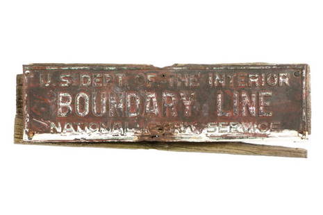
Sold2023C. 1890- Yellowstone National Park Boundary SignThis is an original authentic circa 1890 to early 1900's Yellowstone National Park Boundary sign. The sign reads "U.S. Dept of the Interior Boundary Line National Park Service. This is an early sign uSee Sold Price
Sold2020Map of Pamlico and Albemarle Sounds, Embracing PortionsTitle/Content of Map: Map of Pamlico and Albemarle Sounds, Embracing Portions of Virginia and North Carolina, With Their Strategic Points And Railway Connections. Cartographer: COLTON, GEORGE WOOLWORTSee Sold Price
Sold2022RARE Pre Jug town North Carolina Chicken Saltca. 1900 pre jug town. Damage to top of head. Not signed. Outstanding early transitional pottery item. 4"See Sold Price
Sold20181857 MONK'S NEW AMERICAN MAP OF NORTH AMERICA, UNITED1857 MONK'S NEW AMERICAN MAP OF NORTH AMERICA, UNITED STATES AND TERRITORIES AND MORE AS PICTURED. MEASURES 60" X 66". HAS SOME TEARS, STAINS, AND CRINKLING USUALLY FOUND WITH THESE ROLL DOWN EARLY MASee Sold Price
Sold2023Rare Early 1900's Map of Porto Rico ( Puerto Rico )Rare early 1900's ( copyright of 1908 ) Map of Porto Rico, including Port San Juan, Islands West of Porto Rico, Mayaguez Bay & Port Ponce from Rand, McNally & Co. 8 3/4" X 12". ** fold through the cenSee Sold Price
Sold2021North Carolina Painted Chairgreat paint. Early North Carolina or Virginia Chair.See Sold Price
Sold20211894 Cowles Civil War Map of North Carolina andTitle: 1894 Cowles Civil War Map of North Carolina and Southern Virginia -- General Topographical Map, Sheet III [Plate CXXXVIII] Cartographer: C Cowles (compiled by) Year / Place: 1894, Washington MaSee Sold Price
6 days LeftRail & Road AuctionsFour Early 1900s Steamship Timetables and Travel Brochures - Detroit & Cleveland, Dominion Atlantic$20
5 days LeftBrunk AuctionsFive Piece Prelude International Sterling Tea Service with Silver Plate Tray$500(1 bid)


![Early Map of Tennessee, Daniel Smith, 1795: A MAP OF THE TENNASSEE [sic] GOVERNMENT FORMERLY PART OF NORTH CAROLINA TAKEN CHIEFLY FROM SURVEYS BY GENL. D. SMITH & OTHERS, drawn by Daniel Smith, engraved by Joseph T. Scott, for "General Atlas Fo](https://p1.liveauctioneers.com/525/272425/142901899_1_x.jpg?height=310&quality=70&version=1671337478)


![Large Map of North Carolina and South Carolina: Large Map of North Carolina and South Carolina With map of Georgia and Florida[separately] on versos Cartographer: George Franklin Cram Dated: Circa 1900](https://p1.liveauctioneers.com/5614/198722/101907570_1_x.jpg?height=310&quality=70&version=1618847492)


![1894 Cowles Civil War Map of North Carolina and: Title: 1894 Cowles Civil War Map of North Carolina and Southern Virginia -- General Topographical Map, Sheet III [Plate CXXXVIII] Cartographer: C Cowles (compiled by) Year / Place: 1894, Washington Ma](https://p1.liveauctioneers.com/5584/230022/119005423_1_x.jpg?height=310&quality=70&version=1639520429)


![[Confederate] Sword & Effects of North Carolina Officer (1 of 16)](https://p1.liveauctioneers.com/7226/325455/175169159_1_x.jpg?height=282&quality=70&version=1712370394)

![[Confederate] Portrait of North Carolina Officer (1 of 2)](https://p1.liveauctioneers.com/7226/325455/175169161_1_x.jpg?height=282&quality=70&version=1712370394)


![[Yakima War] William Francis Gaston Unpublished Ambrotype (1 of 1)](https://p1.liveauctioneers.com/7226/322253/173251526_1_x.jpg?height=282&quality=70&version=1710356357)


