Sold2021Carolina’s with parts of Georgia and Virginia, earlyTitle: Carolina’s with parts of Georgia and Virginia, early map of southern United States, by Bonne/ Raynal 1780 Date/Period: 1780 Materials: Copperplate engraved Size: 13 1/2 x 9 3/4'' Shows aSee Sold Price
Sold2017Map of United States, Texas & Oklahoma as 1 TerritoryEarly map of the United States with Texas and Oklahoma as one territory. W. R. Chambers. Circa 1850 map of the United States extends into the Great Plains here split up between Nebraska and Kanzas TerSee Sold Price
Sold2015Early MapEarly map of The United States. Marked "New Indexed Pictorial Map of the United States and World....Published By J. R. Spaulding & Co....". Map 43" x 61".See Sold Price
Sold2022Early Hand Drawn Map of United States in 1817,by Mary Young, image area 20" X 30" plus frame.See Sold Price
Sold2020Early Map of America, Eastern United States, M. SeutterTitled "Novi Belgii in America Septentrionali" with very elaborate cartouche and with vignette view of New Amsterdam (New York). Exquisite color, well preserved, laid down. Size: 19 7/8" x 22 3/4" (siSee Sold Price
Sold20231844 ATLAS Geography 19 MAPS Early America United States Southern School1844 ATLAS Geography 19 MAPS Early America United States Southern School Jesse Olney was a 19th-century American historian who published a number geographical and history readers including his famousSee Sold Price
Sold2024Pair Early 19thC Maps Of The United StatesThe United States Of America published By Cummings & Hilliard No. 1 Cornhill Boston Wightman Sc. , United States J.H. Young Sc.See Sold Price
Sold20201873 Geological Map of the United States Compiled byThis colorful map of the United States was compiled by Professors C.H. Hitchcock and W.P. Blake and is one of the most important early geological maps of the United States, one which would be copied bSee Sold Price
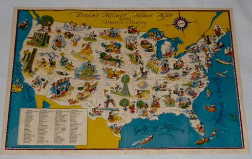
Sold2022Walt Disney Dixon's Mickey Mouse Map of United StatesEarly Disneyana collectible map. Copyright Walt Disney Enterprises 1935. Rare early pictorial map of the United States , richly illustrated with Disney character vignettes in each of the 48 states, MiSee Sold Price
Sold2016JOHN MELISH (SCOTLAND/AMERICAN 1771-1822), EARLY ANDJOHN MELISH (SCOTLAND/AMERICAN 1771-1822), EARLY AND RARE MAP OF THE UNITED STATES OF AMERICA, C.1813. ENTERED AS THE ACT DIRECTS AND PUBLISHED BY JOHN MELISH, PHILADELPHIA, JUNE 1813. SIGHT 13 X 17 1See Sold Price
Sold2017LARGE LOT of EARLY BLOCKS, PUZZLE and MORELot includes several late 19th early 20th century toys. Several block sets, a Bliss 19th century Croquet set in wood box, and a early McLoughlin Bros Map of the United States puzzle. Condition varies.See Sold Price
Sold2018Map of the United States Solomon Schoyer 1826 EngravingWonderful Early 19th Century Antique Map of the United States - By Solomon Schoyer. Map of the United States Drawn from the Most Approved Surveys. New York: Solomon Schoyer, 1826. An Engraved foldingSee Sold Price
Sold2017Early Map of Georgia, John Payne, Circa 1810John Payne (American, 18th/19th century), "Georgia from the latest Authorities 1810"-1810/11. An early American engraved map of the Southern United States by mapmaker John Payne (American, 18th/19th cSee Sold Price
Sold2021Scarce 1882 RR map of U. S. by Rand McNallyEarly McNally copperplate engraved map of the United States showing complete railway network throughout the country 150 years ago. Without the encumbrance of roads, the viewer can get an excellent ideSee Sold Price
Sold2020Early United States Roll-Up MapEarly United States roll-up map. Published by J. H. Colton / New York / 1853. 44 1/2" x 36".See Sold Price
Sold2017Colton: Map of California Nevada Utah Colorado ArizonaColton's Map of California, Nevada, Utah, Colorado, Arizona & New Mexico, 1865/1869. Early edition of Colton's map of the Southwestern United States. Unlike in the prior edition, Nevada is no longer tSee Sold Price
Sold2022LARGE EARLY MAP"The Washington Map of The United States", 1861, approximate size 69 1/2" x 69", with early thin linen backingSee Sold Price
Sold2016Early Map of The Michigan Territory by CareyThe Upper Territories of the United States, 1814. Matthew Carey (1760-1839). Engraved map with original hand color in outline. Philadelphia, 1814. 22 x 17 1/4 inches sheet. The map reflects a very earSee Sold Price
Sold2024Early Map of North AmericaMap of North America Hand Colored Map. Map showing the Mexico when it contained California and Texas, as well as the United States claim on the west coast stretching to meet the Russian Possessions ofSee Sold Price
Sold2021Early map with Large Texas & CaliforniaEarly map with large Texas and huge Upper California. Contains an inset of Gold Regions of California and highlights the western half of the United States. Inset shows details of rivers and place nameSee Sold Price
Sold20184- EARLY GAMES w/ BOXESIncludes Messenger Boy and Checkers, Sectional Steam Hose, Dissected Map United States, and Postal Delivery Boys. All look mostly complete. Boxes with wear and loss. Largest 17" Very GoodSee Sold Price
Sold2021Northern United States, NY, NJ, MD, PA and the NewTitle: Northern United States, NY, NJ, MD, PA and the New England states, By Bonne/ Raynal 1780 Date/Period: 1780 Materials: Copperplate engraved Size: 13 1/2 x 9 3/4'' Early map of a recognized indepSee Sold Price
Sold2024Willem Blaeu, Map of The AmericasAmsterdam, 1617. Together with "Early Maps" by Tony Campbell, Abbeville Press and "The United States in Old Maps and Prints, Eduard Van Ermen. 3 pieces Sight size: 16-1/2"h x 22"w Overall: 23-1/2"h xSee Sold Price
Sold20231795 Joseph Scott Map Of DelawareScarce early 1795 Scott's Map Of Delaware from his The United States Gazetteer. Measures 7 1/2 x 6 inches in matt. Framed.See Sold Price
Jun 08Early American History Auctions1853 Specialized Map, Railroads in the United States in Operation and Progress... Treasury Deptment$200(1 bid)
Jun 08Early American History Auctionsc 1797 JOHN ADAMS, President of the United States of America. Historical Liverpool Creamware Pitcher$2,000
2 days LeftThe Magnusson GroupFour (4) Early Mixed Date United States Proof American Silver Eagles$200(7 bids)
Featured5 hrs LeftJasper52Johnson's New Military Map of the United States Showing the Forts, Military Posts &C. With Enlarged$65
Featured5 hrs LeftJasper52Rand, McNally & Co.'S New Commercial Railroad Map of the United States [Chicago to Denver]$25(1 bid)
Featured5 hrs LeftJasper52Railroad Map of the United States Showing the Through Lines of Communication...$50
5 days LeftKCM GalleriesLarge Detailed Original Oil Painting United States Map Julius Lira Salazar 48 x 36 inches$1,800


![Rand, McNally & Co.'S New Commercial Railroad Map of the United States [Chicago to Denver] (1 of 1)](https://p1.liveauctioneers.com/5584/329422/177662153_1_x.jpg?height=282&quality=70&version=1715717898)


