Sold2017Early Map of Georgia, John Payne, Circa 1810John Payne (American, 18th/19th century), "Georgia from the latest Authorities 1810"-1810/11. An early American engraved map of the Southern United States by mapmaker John Payne (American, 18th/19th cSee Sold Price
Sold2022(SAVANNAH.) J.F. Minis; after John McKinnon. [Map of the Savannah, Georgia Common, Garden, and Farm(SAVANNAH.) J.F. Minis; after John McKinnon. [Map of the Savannah, Georgia Common, Garden, and Farm Lands]. Large lithographed layout of an early survey of Savannah, Georgia, circa 1800. 19½x28&#See Sold Price
Sold2021John Adam, Alexandria, VA, circa 1810-15.Early punch ladle, John Adam, Alexandria, VA, circa 1810-15, the bowl is circular with a slightly raised rounded bowl drop and long narrow fiddle handle with strongly downturned tip. Script monogram 'See Sold Price
Sold2018(8) Sterling & coin spoons incld. John & Peter TargeeGroup of eight sterling and coin silver stuffing spoons, early to mid 19th century, comprising: (2) sterling tablespoons marked Has. W. Kennard & Co. 8.5"l; (1) circa 1810, John & Peter Targee coin siSee Sold Price
Sold2022JOHN MILES PENN. MUSKETCirca early 1800's drum conversion US 1/2 stock percussion musket stamped MILES US (John Miles of Pennsylvania). Was a circa 1810 flintlock originally. 57.5 inches long, about 75 caliber.See Sold Price
Sold2018Early Map of New England: Robert MordenReproduced from the Original in the John Carter Brown Library, Brown University, Circa 1960's. Colored Collotype, Title: A map of New England, New Yorke, New Jersey, Virginia and Maryland Sold By RobeSee Sold Price
Sold2022Payne/Low, Map of Tennessee Government, 1799A MAP OF THE TENNASSEE[sic] GOVERNMENT FROM THE LATEST SURVEYS, 1799, engraved for John Payne's NEW AND COMPLETE UNIVERSAL GEOGRAPHY, published by John Low, New York, 1799. This early copperplate engrSee Sold Price
Sold2020Southern Country Federal Painted Yellow Pine TableCirca 1810. Having a thick three board top with pegged frame and nice early deep blue painted surface. H27 5/8" W39 1/8" L73 1/2" Sold from the collection of a Sparta, Georgia historic home.See Sold Price
Sold2023Early Framed Needlework, Family Parlor Scenedepicting three figures and a parrot on perch, circa 1790-1810. Frame size: 8 1/2" high, 10" wide; sight size: 6 1/2" high, 8" wide. Not examined out of frame. Provenance: John Walton, Inc., invoice aSee Sold Price
Sold2022(Early 20th c) MAPS OF EUROPE / MANY WARTIMEBataille de la Marne, French and British Front 1917, Ordnance Surveys Loughborough, Derby, Rickmansworth, Nouveau Plan de Paris Monumental N.B. circa 1890, printed by Defrenoy (Paris, France), overallSee Sold Price
Sold2023MAP, Connecticut, ReidConnecticut. John Reid, Connecticut from the Best Authorities, from Winterbotham's History of America, 1796 (circa). Black & White. This early and uncommon map of Connecticut was engraved by BenjaminSee Sold Price
Sold2023Scarce 1820-30s Craven Family 2gal JarScarce 1820-30s Craven Family 2gal Jar. Talk about a rare example in early southern pottery, this is circa 1820-30s White County Georgia made by either John Vandevere Craven (1798-1877) born in NorthSee Sold Price
Sold2017John Carey. North America map(English, 1754-1835). "Part of North America comprehending Ohio, New England, New York, New Jersey, Pennsylvania, Maryland, Virginia, Carolinas & Georgia" (sic) hand colored map, circa 1782, 9 1/2 x 1See Sold Price
Sold2017Important early map of St. Johns Island by T. JefferysA Map of the Island of St. John in the Gulf of St. Laurence...Thomas Jefferys (c. 1719 – 1771). Copperplate engraved map with handcolor in outline. London: Sayer & Bennett, 1775. 21 1/2 x 29 inchesSee Sold Price
Sold2023circa 1810 Early American Fabric Sample w/ EagleAntique circa 1810 early American Fabric Fragment with Eagle. Matted. 12" x 10".See Sold Price
Sold2023Scarce early McNally map of Georgia - 1881Early and scarce 1881 Rand McNally Indexed Atlas of the World map of Georgia. Highly detailed, showing counties, towns, rivers, mountains, lakes, roads, railroads, stations, swamps, topography, etc. PSee Sold Price
Sold2021Wilkes, John 1810 Map. ItalyCopper Engraved Map Published 1796-1828 London for "Encyclopaedia Londinensis, or universal dictionary of arts, sciences and literature" by John Wilkes et al. Paper Size: 10.5 x 8.5 inch (27 x 22cm) TSee Sold Price
Sold2023George III / Regency Mahogany Cellarette on StandLate George III or early Regency cellarette, circa 1810-1830, on later stand, the rectangular mahogany box with hinged lid and lead liner, on a rectangular base with reeded legs. 29.5" H x 17.5" W x 1See Sold Price
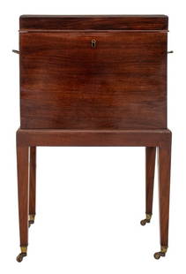
Sold2019Early American Yellow Pine One Drawer StandCirca 1810 early American original paint decorated one drawer stand. All original condition. Measuring approx. 28" tall x 22" wide x 21" deep. Overall condition is very good (see photos). New EnglandSee Sold Price
Sold2022Antique NYC J and P Targee American Coin Silver SpoonsThis is an antique set of six large American coin silver spoons from New York Silversmiths John & Peter Targee circa 1810. Each is monogrammed for what appears to be "EG" and depicts a crest at the haSee Sold Price
Sold2018Horn & Sterl Snuff Box John Roberts SheffieldHorn And Sterling Snuff Box John Roberts Sheffield Circa 1810. 1 1/2" DiameterSee Sold Price
Sold20164 Hand colored early maps4 Hand colored early maps including Normandie, circa 1940. Taped; stained; tears; several small holes. 24 1/2 inches wide x 19 inches high.See Sold Price
Sold2023John Gibson, Early Map of Louisiana and British ColoniesThis interesting map was issued to illustrate the part of Louisiana being rapidly settled by British subjects at the conclusion of the French and Indian War. Publication: Gentleman’s Magazine anSee Sold Price
2019Early English road map by John OgilbyHeading: (Maps) Author: Ogilby, John Title: The Road from London to St. Neotts in Com. Hunt. Continued to Oakeham in Com Rutland Place Published: London Publisher: Date Published: 1675See Sold Price
May 14Akiba Galleries(2 Pc) Allain Manesson Mallet Description De L'Univers 2 Vol. German Translation$200(1 bid)
7 hrs LeftAmelia Jeffers, Auctioneers & AppraisersUNUSUAL SOUTHERN TILT-TOP CANDLESTAND ATTRIBUTED TO LEVI OR JOHN COCHRAN (MARSHALL COUNTY,$500(2 bids)
5 days LeftJasper521810 Ainslie map of County Renfrew near Glasgow in Scotland -- Map made out for John Wilson ESQ.rs$50
May 15University ArchivesDeclaration of Independence, Very Early British Publ. in Gentleman's Magazine & Rare Map$1,000
4 days LeftJohn Moran Auctioneers, Inc.Edgar Alwin Payne (1883-1947), Riding near Canyon de Chelly$35,000
May 16Potter & Potter AuctionsCHOUINARD, Roger. 7UP / The Island of Pure Refreshment. Circa 1970s. Colorful...$150


![(SAVANNAH.) J.F. Minis; after John McKinnon. [Map of the Savannah, Georgia Common, Garden, and Farm: (SAVANNAH.) J.F. Minis; after John McKinnon. [Map of the Savannah, Georgia Common, Garden, and Farm Lands]. Large lithographed layout of an early survey of Savannah, Georgia, circa 1800. 19½x28&#](https://p1.liveauctioneers.com/199/251723/130782424_1_x.jpg?height=310&quality=70&version=1655133895)


![Payne/Low, Map of Tennessee Government, 1799: A MAP OF THE TENNASSEE[sic] GOVERNMENT FROM THE LATEST SURVEYS, 1799, engraved for John Payne's NEW AND COMPLETE UNIVERSAL GEOGRAPHY, published by John Low, New York, 1799. This early copperplate engr](https://p1.liveauctioneers.com/525/230966/119655004_1_x.jpg?height=310&quality=70&version=1640205832)