Sold20231795 Joseph Scott Map Of DelawareScarce early 1795 Scott's Map Of Delaware from his The United States Gazetteer. Measures 7 1/2 x 6 inches in matt. Framed.See Sold Price
Sold2023Early Map of Tennessee, Daniel Smith, 1795A MAP OF THE TENNASSEE [sic] GOVERNMENT FORMERLY PART OF NORTH CAROLINA TAKEN CHIEFLY FROM SURVEYS BY GENL. D. SMITH & OTHERS, drawn by Daniel Smith, engraved by Joseph T. Scott, for "General Atlas FoSee Sold Price
Sold20231795 Map, Maryland & Delaware [18th c. Cartography]Engraved map of Maryland and Delaware printed in 1799, based on a 1795 edition produced by Samuel Lewis. Drawn by A. Anderson, engraved by J. Scoles. Includes an inset map of the Continuation of the PSee Sold Price
Sold20231795 J. Denison & A. Doolittle Maryland/Delaware Map1795 J. Denison & A. Doolittle Maryland/Delaware Map of the States Maryland And Delaware by J. Denison. 7 1/2 x 10 in acid free matt.See Sold Price
Sold2023THE UNITED STATES GAZETTEER (1795) JOESPH SCOTTwith state fold out maps Printed-Philadephia Condition- missing (1) mapSee Sold Price
Sold2016MATHEW CAREY (AMERICAN, 1760-1839) MAP OF DELAWAREMATHEW CAREY (AMERICAN, 1760-1839) MAP OF DELAWARE, hand-colored engraving on paper, titled "Delaware from the best Authorities", engraved by William Barker, published Philadelphia, 1795. Modern frameSee Sold Price
Sold20151st Edition. Chief Joseph Biography of a Great IndianFee, Chester Anders. Chief Joseph The Biography of a Great Indian with a Foreword by Colonel Charles Erskine Scott Wood with Maps and Illustrations. New York: Wilson-Erickson Inc. 1936. 1st Edition. OSee Sold Price
2023MAP OF MARYLAND AND DELAWARE BY JOHN REID.Engraved map on laid paper, published by John Reid, New York. "The States of Maryland and Delaware, from the Latest Surveys, 1795" with Chesapeake Bay in the middle. Stains, minor creases, glued down.See Sold Price
Sold2021Colton’s map of the Southern States.Title: Coltonâ€â„¢s map of the Southern States. Publication Date: 1861 Cartographer: J. Calvin Smith Publisher: Joseph Hutchins Colton Description: Including Maryland, Delaware, Virginia, KenSee Sold Price
Sold2022MAP: "An Accurate Map of Hindostan and India", from the best Authorities, 1795, published by MatthewMAP: "An Accurate Map of Hindostan and India", from the best Authorities, 1795, published by Matthew Carey (1760- 1839), Philadelphia, J.T. Scott sculp., engraved for Carey's American Edition of GuthrSee Sold Price
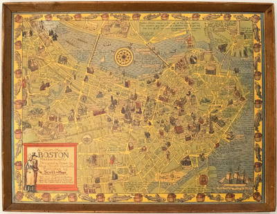
Sold20191950s Garfield Pictorial Map of Boston -- A Scott-MapTitle: 1950s Garfield Pictorial Map of Boston -- A Scott-Map of Boston Massachusetts Date: ca. 1950, Concord, MA Cartographer: A Scott Garfield Size: 20.7 x 27 in. Additional Information: A very attraSee Sold Price
Sold2018Map, "Delaware County, New York, Philadelphia, 1856Map, "Delaware County, New York, From Actual Survey by Jay Could, Published by Collins G. Keeney, Philadelphia, 1856, various county scenes on top margin, map is damages with some loss at top, size isSee Sold Price
Sold2021MAP, Delaware, FinleyDelaware. Anthony Finley, Delaware, from A New General Atlas..., 1824 (circa). Hand Color. This handsome map of the state details the county seats, roads, towns and settlements, and watershed. It showSee Sold Price
Sold2019Walker, John 1795 Map of North America. USA CanadaCopper Engraved Map Published 1795, London for "Elements of Geography, and of Natural and Civil History" by John Walker. Centre fold as published. Paper Size: 10 x 8.5 inch (26 x 22cm) Split on centreSee Sold Price
Sold2019Walker, John 1795 Map of IrelandCopper Engraved Map Published 1795, London for "Elements of Geography, and of Natural and Civil History" by John Walker. Centre fold as published. Paper Size: 10 x 8.5 inch (26 x 22cm) Split on centreSee Sold Price
Sold2019Walker, John 1795 Map of The West Indies. CaribbeanCopper Engraved Map Published 1795, London for "Elements of Geography, and of Natural and Civil History" by John Walker. Folds as published. Paper Size: 14.5 x 8.5 inch (37 x 22cm) Minor toning on lefSee Sold Price
Sold2019Walker, John 1795 Map of PolandCopper Engraved Map Published 1795, London for "Elements of Geography, and of Natural and Civil History" by John Walker. Centre fold as published. Paper Size: 10 x 8.5 inch (26 x 22cm) Small split onSee Sold Price
Sold20231795 Map of South American by Mathew Carey, Philadelphia16.5 x 21.5 inches, sight. Framed, 21.5 x 27 inches. Condition reports are not available for the items in this catalog. These are antique and vintage items, and will show signs of use and wear. We havSee Sold Price
Sold2019Walker, John 1795 Map of The World. Twin HemispheresCopper Engraved Map Published 1795, London for "Elements of Geography, and of Natural and Civil History" by John Walker. Folds as published. Paper Size: 14.5 x 8.5 inch (37 x 22cm)See Sold Price
Sold2019Walker, John 1795 Map of Hindoostan or IndiaCopper Engraved Map Published 1795, London for "Elements of Geography, and of Natural and Civil History" by John Walker. Centre fold as published. Paper Size: 10 x 8.5 inch (26 x 22cm) Some toning, moSee Sold Price
Sold2019U S Coast Survey 1896 Map. Delaware Bay, Salt Lake Utah"Sketch Showing Extension of Triangulation of Delaware Bay with sub-sketches of Salina and Salt Lake Bases" Large Lithograph Map Published 1896, Washington for "U.S. Coast and Geodetic Survey" Folds aSee Sold Price
Sold2019Robertson & Kitchin 1795 Map. Panama, Ecuador etc"Map of the Countries on the South Sea from Panama to Guayquil" Copper Engraved Map Published 1795, London for "The History of America" by Dr. William Robertson. Drawn & Engraved by Thomas Kitchin. FoSee Sold Price
Sold2019Walker, John 1795 Map of the World on Mercators Proj."General Chart on Mercators Projection" Copper Engraved Map Published 1795, London for "Elements of Geography, and of Natural and Civil History" by John Walker. Centre fold as published. Paper Size: 1See Sold Price
Sold2019Walker, John 1795 Map of ItalyCopper Engraved Map Published 1795, London for "Elements of Geography, and of Natural and Civil History" by John Walker. Centre fold as published. Paper Size: 10 x 8.5 inch (26 x 22cm) Very minor toniSee Sold Price
6 days LeftHunt and Peck Estate Services, Inc.Lot of 3 small maps from Scott's Gazeteer "Vermont, New Hampshire and N.W. Territories"$100(1 bid)
4 days LeftJasper521777 GENERAL HISTORY of CHINA by Moyriac de Mailla 3 VOLUMES antique in FRENCH$950
May 16Freeman's | HindmanJean-Martial Frédou (French, 1711-1795) Portrait of Louis-Joseph-Xavier of France, Duke of$2,500
4 days LeftJasper521896 Cram Map of Virginia, West Virginia, Maryland and Delaware -- Railroad and County Map of$40
May 15University ArchivesFeb. 1777 Issue of The Gentleman's Magazine with Superb Map of Philadelphia$140(1 bid)
May 16Freeman's | HindmanJohn Frederick Herring the Elder (British, 1795-1865) Memnon, a Bright Bay, William Scott up,$35,000
6 days LeftHunt and Peck Estate Services, Inc.ANTONIO ZATTA (ITALIAN, 18TH CENTURY) MAP OF VIRGINIA$80(2 bids)
6 days LeftHunt and Peck Estate Services, Inc.1867 United States General Land Office "Rapport af Chefen fur Land-Kontoret i Furenta Saterna."$200
JG AutographsMilitary & Aviation Notables Collection of 12 Items Including "Tex" Hill and Charles W. Lindbergh$25(1 bid)
4 days LeftJasper521794 PHARMACOLOGY TREATISE on NUSHELLS by J Friderich ANTIQUE in German PHARMACY$160
6 days LeftHunt and Peck Estate Services, Inc.1973 Roald Dahl "Charlie in the Chocolate Factory" Revised Edition$50


![Early Map of Tennessee, Daniel Smith, 1795: A MAP OF THE TENNASSEE [sic] GOVERNMENT FORMERLY PART OF NORTH CAROLINA TAKEN CHIEFLY FROM SURVEYS BY GENL. D. SMITH & OTHERS, drawn by Daniel Smith, engraved by Joseph T. Scott, for "General Atlas Fo](https://p1.liveauctioneers.com/525/272425/142901899_1_x.jpg?height=310&quality=70&version=1671337478)
![1795 Map, Maryland & Delaware [18th c. Cartography]: Engraved map of Maryland and Delaware printed in 1799, based on a 1795 edition produced by Samuel Lewis. Drawn by A. Anderson, engraved by J. Scoles. Includes an inset map of the Continuation of the P](https://p1.liveauctioneers.com/7226/275519/144720286_1_x.jpg?height=310&quality=70&version=1673742614)