Sold2024East India islands & Indochina. Dutch E. Indies. Philippines. THOMSON 1817 mapTITLE/CONTENT OF MAP: East India Isles [and Birman Empire] A large map of the Dutch East Indies, Indochina and the Philippines. "Pinang" (Penang), "Bankok" (Bangkok), "Manilla" (Manila), and the StraiSee Sold Price
Sold2023FRENCH INDOCHINA & DUTCH EAST INDIES Siam Burma Penang Manila Singapore 1912 mapTitle: FRENCH INDOCHINA & DUTCH EAST INDIES Siam Burma Penang Manila Singapore 1912 map Description: Farther India; East Indies Archipelago; Inset maps of Singapore; Penang; Manila' by John BartholomeSee Sold Price
Sold2023Lizars, Daniel 1831 LG Rare HC Map. East India Islands. Philippines Indonesia BorneoLarge Folio Copper Engraved Map Published 1831-2 by John Hamilton, Successor to Daniel Lizars, Edinburgh for "The Edinburgh Geographical and Historical Atlas..." First Edition by Daniel Lizars. Very fSee Sold Price
Sold2022Antigua, Guadeloupe & Marie-Galante. West Indies Caribbean. THOMSON 1817 mapTITLE/CONTENT OF MAP: 'Antigua. Guadaloupe. Mariegalante &c' A map of the French and British Leeward islands of Guadeloupe, Marie-Galante & Antigua DATE PRINTED: Published in 1817 IMAGE SIZE: Approx 5See Sold Price
Sold2023Thomson, John (Pub) 1825 Map. East India Isles. Philippines Indonesia BorneoCopper Engraved Map Published 1825 by John Thomson, Edinburgh for "The Edinburgh School Atlas" by N. R. Hewitt. Maps Engraved by Hewitt. Original Outline Hand Colour. Rare. Paper Size: 10.5 x 8 inch (See Sold Price
Sold2017Weller: Antique Map of Borneo & Philippines, 1863Title/Content of Map: 'Borneo; The Philippine Islands' East Indies. Manila Zebu/Cebu. Date Printed: 1863 Image Size: Approx 32.0 x 43.5cm, 12.5 x 17.25 inches (Large) Type: Antique map with original oSee Sold Price
Sold2017Thomson: Antique Map of West India Islands, 1817A map of the West India Islands including St. Christophers, Nevis and St. Lucia by Scottish cartographer John Thomson for his 1817 "New General Atlas." The map is printed on thick paper and was engravSee Sold Price
Sold2021MALAY ARCHIPELAGO/EAST INDIA ISLANDS PhilippinesTITLE/CONTENT OF MAP: 'Malay Archipelago or East India Islands' Vignettes: Victoria Mount - New Guinea; Near Sarawak - Borneo; Natives of New Guinea; The Bee Bear. The map covers the area from Burma aSee Sold Price
Sold2024Ptolemy & Magini, pub. 1620 - Map of India and Surrounding Islands (East Indies)This early map engraving is from Claudius Ptolemaeus (Ptolemy) and Giovanni Antonio Magini's Geografia cio? Descrittione Universale della Terra Partita in due volumni, Nel Primo de' quali si contengonSee Sold Price
Sold2015(2) DUTCH EAST INDIES DOCUMENTS - Passes for Ship's(2) DUTCH EAST INDIES DOCUMENTS - Passes for Ship's Crews, Island of Ambon, issued from Fort Victoria, March of 1809, Dutch East India Company (VOC), with text in Dutch and Arabic. Signed by Ney, WillSee Sold Price
Sold2019Isles Philippines, Célèbes & Moluques'. East Indies.TITLE/CONTENT OF MAP: 'Carte des Isle Philippines, Célèbes, & Moluques [Map of the Philippines, Sulawesi, and the Maluku Islands]' Philippines, Borneo, Sulawesi, Moluccas / Maluku & Lesser Sunda IslSee Sold Price
Sold2018Thomson: Antique Mpa of Egypt. Nile Valley, 1817TITLE/CONTENT OF MAP: 'Egypt' The map is noteworthy for showing the return route of Eyles Irwin, an Irish poet and civil servant, through Egypt from India, where he been in the service of the East IndSee Sold Price
Sold2017Mallet: Antique Map of South Asia, 1683Inde' The map encompasses the whole of India & Indochina including Burma, Thailand, Malaysia/Singapore and South East Asia. The Maldive islands are shown. The map shows the mythical Lake Chiamay, theSee Sold Price
Sold2018Johnson: Antique Map of Australia & East Indies, 1867Title/Content of Map: Australia, islands of Indonesia, New Guinea & Philippines. Insert of New Zealand Date Printed: 1867 Cartographer: Johnson Material/Medium: Paper Size: 18" x 26 1/2" Please note tSee Sold Price
Sold2021Stanford (Pub) 1894 Lot of 9 Maps of Asia East IndiesIncl Celebes, Sumatra, Borneo, Java, Philippines, Stations of Government Officials in the East Indies, Volcanic System of Malaysia, Moluccas, and Sunda Islands. Lithograph Maps Published 1894 by EdwarSee Sold Price
Sold2024BORNEO & THE PHILIPPINE ISLANDS. East Indies. Manila Zebu/Cebu. WELLER 1863 mapTITLE/CONTENT OF MAP: 'Borneo; The Philippine Islands' DATE PRINTED: 1863 IMAGE SIZE: Approx 32.0 x 43.5cm, 12.5 x 17.25 inches (Large) TYPE: Antique map with original outline colour CONDITION: Good;See Sold Price
Sold2019BORNEO & THE PHILIPPINE ISLANDS. East Indies. ManilaTITLE/CONTENT OF MAP: 'Borneo; The Philippine Islands' DATE PRINTED: 1863 IMAGE SIZE: Approx 32.0 x 43.5cm, 12.5 x 17.25 inches (Large) TYPE: Antique map with original outline colour CONDITION: Good;See Sold Price
Sold2015De Bry (Theodore) - Descriptio Hydrographicathe 2-sheet map of Africa and Asia, from the east coast of Brazil to Japan, charting the first Dutch voyage to the East Indies by Houtman, large titlecartouche upper centre of right sheet, ships, compSee Sold Price
Sold2022Rare Pronk"Dame Au Parasol"Plate,Yongzheng PeriodA rare Chinese Pronk "La Dame Au Parasol" plate, dating from the Yongzheng perioid (1722-1735). A Museum quality rare plate depicting a lady with a parasol. Commissioned by the Dutch East India Co. toSee Sold Price
Sold2023American School, Trading Post in BengalAmerican, 19th century oil on wood panel depicting an aerial view of a Dutch East India Trading Company trading post in Bengal, India, 15 3/4" x 16 3/4" panel, 19" x 20" framed.See Sold Price
Sold2016Netherlands East Indies Keping 1804 proofNetherlands East Indies East India Company, Keping, (S-966), 1804 // AH1219, gilt copper, proof, NGC PF63 Cameo. Rare.See Sold Price
Sold2016Ortelius map of East Indies 1570Heading: Author: Ortelius, Abraham Title: Indiae Orientalis Insularumque Adjacientium Typus Place Published: [Antwerp] Publisher: Date Published: 1570- Description: Copper-engraSee Sold Price
Sold2024Pownall Map of North America with the West India IslandsPOWNALL, Thomas (1720-1805). A New Map of North America with the West India Islands, divided according to the Preliminary Articles of Peace, Signed at Versailles, 20, jan 1783, wherein are particularlSee Sold Price
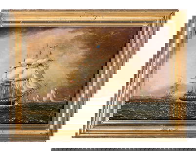
Sold2023James E. Buttersworth (British, 1817-1894)James E. Buttersworth (British, 1817-1894) Old Ironsides off Long Island oil on panel signed J E Buttersworth, lower right 8 1/2 x 12 1/4 inches.See Sold Price
Featured6 days LeftJasper52St Christophers, Nevis & St Lucia. St Kitts. West Indies. THOMSON 1817 old map$120
6 days LeftJasper52Puerto Rico & Virgin Islands. Haiti, Hispaniola or St. Domingo. THOMSON 1817 map$130
6 days LeftJasper52St Christophers, Nevis & St Lucia. St Kitts. West Indies. THOMSON 1830 old map$120
6 days LeftJasper52Puerto Rico & Virgin Islands. Haiti, Hispaniola or St. Domingo. THOMSON 1817 map$130
Featured6 days LeftJasper52The Bahamas, Cuba & Bermuda "or Summer Islands". THOMSON 1817 old antique map$180
6 days LeftJasper52Central America Caribbean Gulf of Mexico chart Ports lighthouses LARGE 1918 map$45
7 days LeftHunt and Peck Estate Services, Inc.1798 Bryan Edwards "The History Civil and Commercial of the british colonies in the west indies$50
1 day LeftTrillium Antique Prints & Rare BooksDavid Roberts - Interior of the Temple of Aboo Simbel$200
May 11Crescent City Auction GalleryWilliam H. Williams (1817-1886), New Orleans "Map of the Sixth District and Carrollton," 1871, H.-$650
Jun 16Broward Auction GalleryATTRIB George Forster (NY,German,1817-1896) oil painting antique$20(2 bids)


![East India islands & Indochina. Dutch E. Indies. Philippines. THOMSON 1817 map: TITLE/CONTENT OF MAP: East India Isles [and Birman Empire] A large map of the Dutch East Indies, Indochina and the Philippines. "Pinang" (Penang), "Bankok" (Bangkok), "Manilla" (Manila), and the Strai](https://p1.liveauctioneers.com/5584/320546/172232433_1_x.jpg?height=310&quality=70&version=1709072904)


![Isles Philippines, Célèbes & Moluques'. East Indies.: TITLE/CONTENT OF MAP: 'Carte des Isle Philippines, Célèbes, & Moluques [Map of the Philippines, Sulawesi, and the Maluku Islands]' Philippines, Borneo, Sulawesi, Moluccas / Maluku & Lesser Sunda Isl](https://p1.liveauctioneers.com/5584/139429/70692793_1_x.jpg?height=310&quality=70&version=1554845662)


![Ortelius map of East Indies 1570: Heading: Author: Ortelius, Abraham Title: Indiae Orientalis Insularumque Adjacientium Typus Place Published: [Antwerp] Publisher: Date Published: 1570- Description: Copper-engra](https://p1.liveauctioneers.com/642/86438/44449716_1_x.jpg?height=310&quality=70&version=1458591928)


![World Coins - East India Company - Victoria - AE Group [2] (1 of 1)](https://p1.liveauctioneers.com/1191/327727/176560293_1_x.jpg?height=282&quality=70&version=1714130530)


