Sold2017Eight Connecticut Directories Some with MapsHeading: z(Directories) Author: Title: Eight Connecticut Directories 1860s On Place Published: Publisher: Date Published: Description: Eight volumes of Connecticut directSee Sold Price
Sold2023Connecticut River RR June 1874 Public TimetableThis is a Connecticut River Railroad June 1874 public timetable. Printed on one sheet of paper, with eight total panels and four to a side, one side shows a complete route map, with the other side shoSee Sold Price
Sold2021Two Framed West Hartford, Connecticut Maps with handTwo Framed West Hartford, Connecticut Mapswith hand coloring by L.J. Richards of West Hartford, Connecticutcirca 1890's24" x 34" framedSee Sold Price
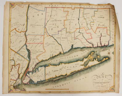
Sold2023EARLY CONNECTICUT MAPHand drawn and colored; "Connecticut and Parts Adjacent", "drawn by Miss. Elizabeth L. Tredwell" "Christ Church Academy 1820", several edge tears; 23" x 30", F-GSee Sold Price
Sold2015Antique Framed Hand-Colored Connecticut MapAntique framed hand-colored Connecticut map, 9 1/2" H x 12 1/2" W under mat. From a Greenwich, CT collector, very good antique condition.See Sold Price
Sold2021Salem Mass. 1901 Directory & MapThe Naumkeag Directory for Salem, Berverly, Danvers, Marblehead, Peabody, Hamilton, Wenham, Middletown and Topsfield. Containing a List of the Inhabitants and Business Firms of the District and OtherSee Sold Price
Sold20221872 Vermont Directory MAP United States Constitution1872 Vermont Directory MAP United States Constitution Government Color The Directory, Rules Constitutions and Manual of Parliamentary Practice was a regularly published government periodical from VermSee Sold Price
Sold2022SAYBROOK, CT DEEDS/LAND SALE DOCUMENTS, 1780s-1790s.A group of eight Connecticut deeds/land transfer documents, 1783-1793, each with multiple signatories: 1. BEAUMONT, SAMUEL, and TULLY, SAMUEL. Single-sheet, written on one side; addressed and noted asSee Sold Price
Sold20241816 MAP SOUTHERN PART OF RUSSIA or MUSCOVY in EUROPE copper engraving ANTIQUEAntique engraved map of Southern part of Russia from A General Atlas, Being A Collection Of Maps Of The World And Quarters, Their Principal Empires, Kingdoms, &c. Containing Fifty Eight Maps And ChartSee Sold Price
Sold2019Eight (8) Augustus Mitchell MapsCollection of eight maps including New Jersey/Maryland Delaware 1872, Two north and South Carolina 1872 maps (15" x 12"), Minnesota 1890 , Florida and the Carolinas 1860, County map of the state of ArSee Sold Price
Sold2022US DEPARTMENT OF DEFENSE. WORLD WAR 2, SUMATRA, INDONESIA AND DUTCH EAST INDIES MAPS (1944-1946)US DEPARTMENT OF DEFENSE. WORLD WAR 2, SUMATRA, INDONESIA AND DUTCH EAST INDIES MAPS (1944-1946). US Army Map Service. Eight maps from Dutch Sumatra and Timor: Gle Jeueng (paper) and Lho'Nga (paper) eSee Sold Price
Sold2022US DEPARTMENT OF DEFENSE. WORLD WAR 2, SUMATRA, INDONESIA AND DUTCH EAST INDIES MAPS (1943-1946)US DEPARTMENT OF DEFENSE. WORLD WAR 2, SUMATRA, INDONESIA AND DUTCH EAST INDIES MAPS (1943-1946). US Army Map Service. Eight maps, from Dutch East Indies: Dutch Timor, Isle of Roti; Portuguese Timor;See Sold Price
Sold20231845 School Map of the Eastern United States1860 School Map of Connecticut.Clark & Tackaburys' Topographical Map of Connecticut..Map is 69 1/2" x 54 1/2"Condition, rolls up, creases, stains, overall wear, tears, some missing pieces to bottom boSee Sold Price
Sold2020Amos Doolittle Map of ConnecticutAmos Doolittle Map of Connecticut. Map: H 12", W 14-1/2" approx; frame size: H 20-1/4",. W 22-1/2". Professionally framed. Collection of Laura Mitler. Please see link for high res photos: https://www.See Sold Price
Sold2018(9) Volumes of "Meriden Directory"(9) Volumes of "Meriden Directory" - Meriden Directories Contain "A General Directory of The Citizens, Business Directory, Street Directory, Map, Officers of The City Government, Churches, Societies,See Sold Price
Sold202219th Century Worcester DirectoriesWorcester Directories and Almanacs: Worcester in 1850, 1855 Worcester Almanac and 1860, 1866 and 1874 Directories. Map in 1850 Book is torn, 1855 Almanac is in fair condition. Others have some wear. PSee Sold Price
Sold20231860 School Map of Connecticut1860 School Map of Connecticut. Clark & Tackaburys' Topographical Map of Connecticut.. Map is 69 1/2" x 54 1/2" Condition, rolls up, creases, stains, overallSee Sold Price
Sold2018Birmingham C1900 Large Map from Kelly's Directory"Kelly's Directory Map of Birmingham" Lithograph Map Published C1900 by Kelly & Co., London. Folds as issued. Paper Size: 29 x 28 inch (74 x 70cm) A couple of small margin tears and chip to right edgeSee Sold Price
Sold2021Eight Antique Maps by HoefnagelEight Antique Maps by Hoefnagel , 17th c., from Civitates Orbis Terrarum, 5 hand-colored, sheets 16 in. x 20 in Provenance: Property deaccessioned from the Louisiana State Museum, proceeds to be usedSee Sold Price
Sold2023Eight Antique Maps of TexasEight Antique Maps of Texas , incl. "Map of the United States and Texas Boundary Line...", 1857-1860 (1902); "Map of a Tour from Independence...by A. Wislizenus, in 1846 and 1847"; "N.W. Corner & Pan-See Sold Price
Sold2023Eight Antique Maps, Mostly EuropeDescription: A group of antique maps including an 18th century map of Spain and Portugal by Thomas Jefferys, a ca. 1800 map of Italy from the Guthrie atlas, an early 19th century Henry Schenck TannerSee Sold Price
Sold2021George III Figured Mahogany Eight Drawer Map CaseBritish, 18th century, in old surface with rich brown color, highly figured top over eight dovetailed drawers with oak linings, probably original gilt brass pulls, brass carrying handles, set on straiSee Sold Price
Sold20181859 Clark & Tackabury Antique Connecticut Wall MapTitle/Content of Map: 1859 Clark & Tackabury Connecticut Wall Map -- Clark & Tackabury's New Topographical Map of the State of Connecticut Date Printed: 1859 Philadelphia Cartographer: Clark and TackaSee Sold Price
3 days LeftCollective HudsonWeller Pottery Louwelsa American Art Pottery Signed Mantel Clock$150(1 bid)
BonhamsSPEED (JOHN) The Kingdome of China Newly Augmented by I.S. 1626, Thomas Bassett and Richard Chis...£900
Jun 23Treasure Quest AuctionsPr. Child's Ulster County, NY 1871-72 Gazetteer & Business Directories$50
Jun 08Holabird Western Americana CollectionsSilver King Coalition Annual Report w/ Fold Out Maps 1908 [165724]$250
BonhamsROWLANDSON (THOMAS) The Grand Master or Adventures of Qui-Hi? in Hindostan. A Hudibrastic Poem i...£10
BonhamsHAWTHORNTHWAITE (SAMUEL) Mr. Hawthornthwaite's Adventures among the Mormons, as an Elder during ...£700
BonhamsCHATTERTON (THOMAS) Autograph fragment, the lower right portion from a lost letter to his sister...£1,500
BonhamsEDWARD III - YORKSHIRE Illuminated Royal Licence, bearing the great seal, Westminster, 15 Novemb...£18,000


![Silver King Coalition Annual Report w/ Fold Out Maps 1908 [165724] (1 of 7)](https://p1.liveauctioneers.com/2699/331499/178846267_1_x.jpg?height=282&quality=70&version=1717095214)


