Sold2019MAP - Puerto Rico. PorcacchiPuerto Rico. Tomaso Porcacchi, S. Giovanni, 1713 (published). Black & White. This captivating map of the island of Puerto Rico is based on the cartography of Giacomo Gastaldi. S. Croce (St. Croix) andSee Sold Price
Sold2019Puerto Rico ( labeled San Giovanni).Title/Content of Map: Puerto Rico ( labeled San Giovanni). Date 1576-1590. Cartographer: Porchelli. Size: 8x12”. Provenance: Republic of Venice Using a mostly forgotten name, the island is decoratedSee Sold Price
Sold2017Thomson: Antique Map of Puerto Rico/Hispaniola, 1815Map: Puerto Rico and Virgin Isles/Haiti, Hispaniola, or St. Domingo Cartographer: Thomson Place & Date: Edinburgh / 1815 Size: 24" x 20 1/8" Condition: outline color; overall age toning and some overpSee Sold Price
2017Thomson: Antique Map of Puerto Rico & Virgin IslandsTitle/Content of Map: 'Porto Rico and Virgin Isles. Haiti, Hispaniola or St. Domingo' Date Printed: 1817 Image Size: Approx 54.0 x 65.0cm, 21.25 x 25.5 inches (Large); Please note that this is a foldiSee Sold Price
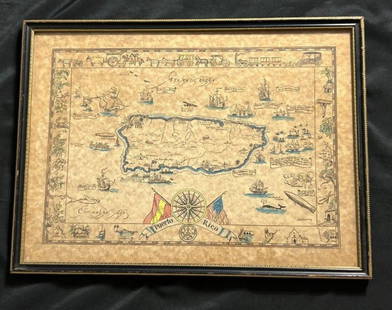
Sold2023Vintage Hand -Colored Pictorial Map of Puerto Rico Circa 1931 by E.B.K. DooleyA vintage hand-colored map of Puerto Rico by E.B.K. Dooley, published c. 1931. This map has a decorative border filled with local plants, wildlife, buildings and transportation. In small scrolls, therSee Sold Price
Sold2016Map of Puerto Rico (San Juan & Vieques), 1895Original engraving from Atlas of the World by Rand McNally, 1895. Features insets of San Juan & Isla of Vieques. Lower section of map page features divisions, islands, lakes, mountains, points of inteSee Sold Price
Sold20201825 Vandermaelen Map of Puerto Rico -- Amer. Sep.Title: 1825 Vandermaelen Map of Puerto Rico -- Amer. Sep. Porto-Rico. No. 69 Cartographer: P Vandermaelen Year / Place: 1825-7, Paris Map Dimension (in.): 18.8 X 21.1 in. This very interesting largerSee Sold Price
Sold2018Rand McNally: Antique Map of Puerto Rico, 1899Porto Rico A detailed Puerto Rico map showing the island divided into seven provinces and featuring many place names, roads, railroads, etc, and a gazeteer in the right margin. Below the main map areSee Sold Price
Sold2022CUBA. Vintage map. Inset Puerto Rico. West Indies. Caribbean 1923 oldTITLE/CONTENT OF MAP: 'Cuba; Inset map of Porto Rico' DATE PRINTED: 1923 IMAGE SIZE: Approx 14.5 x 24.0cm, 5.75 x 9.5 inches (Medium); Please note that this is a folding map. TYPE: Vintage colour mapSee Sold Price
Sold2021MID-CENTURY PUERTO RICO MAP PAINTING ON PANELPainted map of Puerto Rico on wood panel. Supposedly from a 1950s restaurant. Apparently unsigned. Dimensions: H 48.5" x W 96" Condition: Paint losses, wood losses, and surface wear. Black rub line MaSee Sold Price
Sold2019Aguadilla (Puerto Rico) by De Ferrer, 1809Title/Content of Map: Aguadilla (Puerto Rico) by De Ferrer, 1809 Date Printed: 1809 Cartographer: José Joaquín de Ferrer Material/Medium: Engraving Size: 11 3/4" x 15" 1809 Nautical Chart of AguadilSee Sold Price
Sold2018Thomson: Puerto Rico & Virgin Islands/HispaniolaMap Title: Puerto Rico and Virgin Isles/Haiti, Hispaniola, or St. Domingo Cartographer: Thomson Place/Date: Edinburgh / 1815/1817 Size: 24" x 20 1/8" Condition: outline color; overall age toning and sSee Sold Price
Sold2022EBK Dooley Hand Colored Puerto Rico Pictorial MapAntique hand colored map of Puerto Rico by EBK Dooley (Eliza Bellows King Dooley), published 1931. No tares and color it still vibrant.See Sold Price
Sold2018Bowen: Antique Map of Hispaniola & Puerto Rico, 1747Title/Content of Map: A New & Accurate Map of Hispaniola or St. Domingo and Porto Rico Cartographer: Bowen Place & Date: London / 1747 Size: 16 1/2" x 6 3/4" Condition: b&w; upper margin added where tSee Sold Price
Sold2017Mallet: Antique Map of Hispaniola / Puerto Rico, 1719Map: Die Inseln Hispaniola und Port Ricco oder dess Reichen Schhavens Cartographer: Mallet Place & Date: Frankfurt / 1719 Size: 4 3/8" x 5 7/8" Condition: full color; overall age toning, some spottingSee Sold Price
Sold2021Cram: Large Puerto Rico Map with San Juan Harbor InsetTitle/Content of Map: Cram: Large Puerto Rico Map with San Juan Harbor Inset Date Printed: 1897, Chicago Cartographer: George Cram Size: 21" x 13" The large Puerto Rico map from Cram's Atlas of the WoSee Sold Price
Sold2022CUBA PUERTO RICO Jamaica Haiti. Caribbean. BAEDEKER 1909 old antique map chartTITLE OF MAP (NOT PRINTED ON THE PAGE):'Cuba and Porto Rico' Places shown on the map include: Jamaica Puerto Rico Haiti DATE PRINTED: 1909 IMAGE SIZE: Approx 10.0 x 15.0cm, 4 x 5.75 inches (Small) TYPSee Sold Price
Sold2018Thomson: Antique Map of Puerto Rico/Hispaniola, 1815Puerto Rico and Virgin Isles/Haiti, Hispaniola, or St. Domingo Two highly detailed topographical maps on a single sheet from Thomson's influential New General Atlas. The upper map is of Puerto Rico anSee Sold Price
Sold2020Century Co.: Puerto Rico and the Lesser AntillesTitle/Content of Map: Century Co.: Puerto Rico and the Lesser Antilles Date Printed: 1898/1913, New York Cartographer: The Century Co. Size: 10 1/2" x 15 1/4" A wonderfully detailed, post Spanish-AmerSee Sold Price
Sold2020Rand McNally: Puerto Rico with Virgin Islands InsetRand McNally's highly detailed Puerto Rico map featuring many place names and two insets: Islands west of Puerto Rico and the Virgin Islands.; Rand McNally; Chicago / 1921; 12 1/2'" x 9 1/4"; wash colSee Sold Price
Sold2024Puerto Rico Antique Maps (3)Group of 3 antique folding map sea charts. One of Puerto Rico. Another of San Juan Harbor. The third a composite including Mayaguez Bay. Washington, D.C.: 1899. All fold as issued.See Sold Price
Sold2022Map of Cuba, Jamaica & Puerto Rico, J. H. ColtonAn excellently colored map of these islands. Nice impression. Shows railroads, roads, towns, coastal features, islands, topography, bays. Extremely light toning at paper edges. Inset of Porto Rico. 12See Sold Price
Sold2017Colton: Antique Map of Cuba Jamaica Puerto Rico, 1855Map: Colton's Cuba, Jamaica and Porto Rico Cartographer: Colton Place & Date: New York / 1855 Size: 15 1/2" x 13" Condition: light, even overall age toning, otherwise a beautifully preserved exemplarSee Sold Price
Sold2017Colton: Antique Map of Cuba Jamaica & Puerto Rico, 1861Map: Cuba, Jamaica & Puerto Rico Date Printed: 1861 Cartographer: J.H. Colton Material/Medium: Paper Size: 17 1/2" x 14" Condition: Excellent. Small tear near top center and lower left. Tear does notSee Sold Price
2 days LeftJasper52Rand, McNally & Co.'S Map of the Western Hemisphere. Globe Series Compiled from the Latest And Most$340
May 16Potter & Potter AuctionsHARDY, John (1923–2004). Puerto Rico / Delta Air Lines. Cir...$125
2 days LeftJasper52Emilio Pucci Brown Silk and Cotton Button Down Long Sleeves Blouse Shirt Size 36$480
May 19The Heritage Gallery at Sayville Antiques, IncCarlos Osorio Abstract Figural Color Crayon Wash Drawing$50