Sold2023Asia by Herman Moll. Great Wall of China. Mogol empire. Tartaria 1709 old mapTitle: Asia by Herman Moll. Great Wall of China. Mogol empire. Tartaria 1709 old map Description: Asia' by Herman Moll (1709). Antique copperplate map, 29.5 x 19.5cm, 11.5 x 7.75 inches The mythical lSee Sold Price
Sold20181732 Moll Map of Tartary and Central Asia -- GreatTitle/Content of Map: 1732 Moll Map of Tartary and Central Asia -- Great Tartary. With the Tract of the Moscovite Ambassador's Travels from Moscow to Pekin in China… Date Printed: 1732, London CartoSee Sold Price
Sold2022GREAT TARTARY. 'Grande Tartarie'. Russia China N & Central Asia. MALLET 1683 mapTITLE OF THE MAP: 'Grande Tartarie' (De L'Asie) Tartary (Latin: Tartaria) or Great Tartary (Latin: Tartaria Magna) was a name used by Europeans from the Middle Ages until the twentieth century to desiSee Sold Price
Sold2024La Gran Tartaria. Great Tartary. Central/North Asia. ROSSI / CANTELLI 1683 mapTitle: La Gran Tartaria. Great Tartary. Central/North Asia. ROSSI / CANTELLI 1683 map Description: La Gran Tartaria divisa nelle sue parti principali [Great Tartary divided into its main parts] by PubSee Sold Price
Sold2017Herman Moll A New Map of Great Britain 1717. TitlHerman Moll A New Map of Great Britain 1717. Title: 'A New Map of Great Britain According to the Newest and Most Exact Observations'. A large and very intricate map of the British isles with colouredSee Sold Price
Sold2022BEAVER MAP, HERMAN MOLL (DUTCH/BRITISH, 1654-1732)A New and Exact Map of the Dominions of the King of Great Britain on ye Continent of North America containing Newfoundland, New Scotland, New England, New York, New Jersey, Pensilvania, Maryland, VirgSee Sold Price
Sold2015A map of China, Korea and the Japanese Isles, ca. 1779SANTINI, Paolo, L'Empire de la Chine, avec la Tartarie Chinoise d'aprs l'Atlas Chinois. Venice, Remondini, 1779. Original outline colour. 485 x 560mm. China, Korea and Tartary, also showing Japan andSee Sold Price
Sold2017FRAMED WORLD MAP BY HERMAN MOLL, 1719'A New & Correct Map of the Whole World, by Herman Moll, Geographer, 1719.' Hand tinted and framed. Frame size: 73 x 124 cm (28 3/4 x 48 3/4 in.)See Sold Price
Sold2022MOLL, HERMAN. A New Map of the North Parts of America claimed by France under ye Names of Louisiana,MOLL, HERMAN. A New Map of the North Parts of America claimed by France under ye Names of Louisiana, Mississipi, Canada and New France with ye Adjoyning Territories of England and Spain. Large engraveSee Sold Price
Sold2024Map of the North Parts of America Claimed by France by Herman Moll (London, 1720)Map of the North Parts of America Claimed by France by Herman Moll (London, 1720) "A New Map of the North Parts of America claimed by France under ye Names of Louisiana, Mississippi, Canada, and New FSee Sold Price
Sold2019Herman Moll 1654-1732), "A New And Correct Map of theHerman Moll 1654-1732), "A New And Correct Map of the World," 1710, hand colored, H. - 22 in., W. - 38 in.See Sold Price
Sold2020Ides Travels to China 1706 map & with platesHeading: Author: Ides, Evert Ysbrants Title: Three Years Travels from Moscow Over-land to China: Thro' Great Ustiga, Siriana, Permia, Sibiria, Daour, Great Tartary, &c. to Peking... Place Published:See Sold Price
Sold2017Moll - Correct Map of the Whole World, 1719Herman Moll (1654?-1732), cartographer and publisher A New & Correct Map of the Whole World Shewing y.e Situation of its Principal Parts. Viz the Oceans, Kingdoms, Rivers, Capes, Ports, Mountains, WooSee Sold Price
Sold2022Central Asia.- Ides (E. Ysbrants) Three Years Travel from Moscow over-land to China, first EnglishCentral Asia.- Ides (E. Ysbrants) Three Years Travel from Moscow over-land to China, first English edition, engraved additional title, folding engraved map (small hole at fold, tear at fold and anotheSee Sold Price
Sold2019Turkmen Bag FaceCa. 1800 or earlier, 56 x 95 cm, Central Asia, West Turkestan This unusual bag face showing every sign of great age cannot be assigned to any of the tribal groups defined to date. It is finely and regSee Sold Price
Sold2022MOLL, HERMAN. [The World Described].MOLL, HERMAN. [The World Described]. 18 engraved multiple-sheet folding maps with original outline hand-color (i.e., incomplete; no beaver map, no codfish map). Tall folio, 25x12 inches, period calf bSee Sold Price
Sold2023Visscher Map of South East AsiaVISSCHER, Nicolas (1618-1679). Indiae Orientalis, nec non Insularum Adiacentium Nova Descriptio. Engraved map with great original hand color in full. Amsterdam, c. 1698. 20 1/2" x 24 1/8" sheet. ThisSee Sold Price
Sold2018South East Asia.- Ortelius (Abraham) Indiae OrientalisSouth East Asia.- Ortelius (Abraham) Indiae Orientalis Insularumque Adiacientium Typus, map of southern Asia from India across to Java and New Guinea, and including China and Japan to the north, withSee Sold Price
Sold2015De Bry (Theodore) - Descriptio Hydrographicathe 2-sheet map of Africa and Asia, from the east coast of Brazil to Japan, charting the first Dutch voyage to the East Indies by Houtman, large titlecartouche upper centre of right sheet, ships, compSee Sold Price
Sold2016Salor TorbaCa. 1800, 60 x 110 cm, Central Asia, West Turkestan The field design of this rare Salor torba consists of three rows of six octagonal güls; small petrol diamonds decorated with double hooks at each cSee Sold Price
Sold2018Sensitive Life-size Gandharan Terracotta Head of BuddhaCentral Asia, Pakistan, India, and Afghanistan, Gandharan, ca. 2nd to 3rd century CE. An exquisite, life-size terracotta head of the Buddha, depicted nearly in the round, with a wavy coiffure, a generSee Sold Price
Sold2021Dinosaur Skeleton (Psittacosaurus)Central Asia, ca. Early Cretaceous (101 - 126 MYO). This is a significant specimen due to its size, completeness, and originality. The bones were meticulously removed from a single block of matrix andSee Sold Price
Sold2023Khotanlate 18th century, 261 x 130 cm, Central Asia, East Turkestan In the red field of this early rug from the oasis town of Khotan, large dark blue disc medallions are embedded in a basic design of leavesSee Sold Price
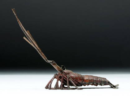
Sold201719th C. Japanese Bronze Articulated Crustacean - SignedEast Asia, Japan, Edo to Meiji period, ca. mid 19th to early 20th century CE. A bronze articulated model of a lobster, with a signature on the underside of its carapace. Meticulously constructed of nuSee Sold Price
2 days LeftAnnzstiques Auction HouseCanon Auto Zoom 518 SV Super8 8mm Film VINTAGE Movie Camera Japan Works GREAT!!!$590
12 hrs Left1 Great Deal Auctions Jade Asian Decor 258cts Real Jade White and Green Tai-Ji And Pi-Xiu Dragon Coin Amulet$1
May 14Fleischer's Auctions1755 Map Partie de l'Amerique Septentrionale, qui comprend Le Cours de L'Ohio...$200(3 bids)
6 days LeftToomey & Co. AuctioneersNamikawa Yasuyuki, Fine vase with sparrows, young bamboo and daisies$3,000(1 bid)
May 14Fleischer's AuctionsLincoln's Funeral Cortège Book by Custodian of Lincoln's Tomb$150(2 bids)
14 hrs LeftTrillium Antique Prints & Rare BooksBlaeu?s Le Theatre du Monde? ? Volume 3 with 57 Fold Out Maps with Original Hand-coloring, 4 Smaller$1,000(1 bid)
14 hrs LeftTrillium Antique Prints & Rare BooksKarl Bodmer - Dog-Sledges of the Mandan Indians. 29$300
14 hrs LeftTrillium Antique Prints & Rare BooksKarl Bodmer - Tower-Rock, view on the Mississippi. 9$300
12 hrs Left1 Great Deal Auctions Charles Bragg OUT OF COURT SETTLEMENT Lithograph Lawyer Judge Art$1(1 bid)


![La Gran Tartaria. Great Tartary. Central/North Asia. ROSSI / CANTELLI 1683 map: Title: La Gran Tartaria. Great Tartary. Central/North Asia. ROSSI / CANTELLI 1683 map Description: La Gran Tartaria divisa nelle sue parti principali [Great Tartary divided into its main parts] by Pub](https://p1.liveauctioneers.com/5584/314775/168780611_1_x.jpg?height=310&quality=70&version=1704837726)


![MOLL, HERMAN. [The World Described].: MOLL, HERMAN. [The World Described]. 18 engraved multiple-sheet folding maps with original outline hand-color (i.e., incomplete; no beaver map, no codfish map). Tall folio, 25x12 inches, period calf b](https://p1.liveauctioneers.com/199/251723/130782476_1_x.jpg?height=310&quality=70&version=1655133895)