Sold2023MAP, Mid-Atlantic US, HomannMap Created to Promote German Immigration to the New World. Colonial Mid-Atlantic United States. Johann Baptist Homann, Virginia Marylandia et Carolina in America Septentrionali Britannorum IndustriaSee Sold Price
Sold2017Beers: Antique Map of Mid Atlantic Midwest US, 1875Title: 1875 Warner Beers Map of Mid Atlantic and Midwest United States -- County Map of New York, New Jersey, Pennsylvinia, Ohio, Deleware, Maryland, Virginia, West Virginia Cartographer: Warner BeersSee Sold Price
Sold2024French Map of the Mid-Atlantic CoastAntique French Map of the Mid-Atlantic Coast, "Carte de la Virginie, de la Baye Chesapeak, et Pays Voisins", by Jacques Bellin, Paris, c. 1761, with later hand-coloring, sight 8 in. x 12 in., framedSee Sold Price
Sold20188 pcs. Pennsylvania & Mid Atlantic Maps incl. ca8 pcs. Pennsylvania & Mid Atlantic Maps incl. ca 1820 double page map of PA-- Dimensions: ---See Sold Price
Sold20211833 SDUK Map of US Mid-Atlantic -- North America SheetTitle: 1833 SDUK Map of US Mid-Atlantic -- North America Sheet VII - Pennsylvania, New Jersey, Maryland, Delaware, Columbia and part of Virginia Cartographer: SDUK Year / Place: 1833, London Map DimenSee Sold Price
Sold2022[MAP]. HOMANN, Johann Baptist (1663-1724). Virginia, Marylandia et Carolina in America[MAP]. HOMANN, Johann Baptist (1663-1724). Virginia, Marylandia et Carolina in America Septentrionali. Nuremberg, [ca 1714].   Engraved map of the Mid-Atlantic with hand-coloring in wash and outlSee Sold Price
Sold20231755 Robert De Vaugondy Map of North America Large1755 Robert De Vaugondy Map of America. Mid-Atlantic, New York, New Jersey, Pennsylvania Virginia, Maryland, New England, Carolina and Ohio. Partie De L'Amerique Septentrionale. Map in matte is aboutSee Sold Price
Sold20171809 Pinkerton Map of North East United States1809 Pinkerton Map of North East and Mid-Atlantic United States -- United States of America Northern Part J. Pinkerton 1809 London 20 x 27.5 in. plus matting. A detailed sharp map of the Mid-AtlanticSee Sold Price
Sold2023Vintage Oil Company Folded MapsVintage Oil Company Folded Maps, 1940s - 60s, Mid Atlantic and Southeast, Esso, Gulf, Standard Oil, great graphics. CONDITION: Lightly used, some edge wear form age and use.See Sold Price
Sold2017H. Moll: Antique Map of New England & mid Atlantic 1746Title/Content of Map: Important and rare Map of New England & mid Atlantic colonial America Date Printed: 1746 Cartographer: Thomas Salmon & Herman Moll Material/Medium: Paper Size: 14 1/2" x 9 1/2" CSee Sold Price
Sold2017Johnson's Delaware and MarylandMap: Johnson's Delaware and Maryland Description: A map of these two mid-Atlantic states with plenty of topographical and settlement details as well as showing roads and railroads. Counties are colorSee Sold Price
Sold2023Collection of Vintage United States MapsAntique antique MAPS, mainly New England, Mid-Atlantic, Virginia, and more. Approximately 50 pieces. As is, as shown. Provenance: Phyllis Lucas Gallery, NYC.See Sold Price
Sold2022MAP OF THE NORTHERN AND MID-ATLANTIC STATESMAP OF THE NORTHERN AND MID-ATLANTIC STATES“A Map of the Northern and Middle States: Comprehending the Western Territory and the British Dominions in North America from the best Authorities̶See Sold Price
Sold2022North eastern and mid Atlantic colonial America, 1780/81 scarce map by J. B. NolinTitle: North eastern and mid Atlantic colonial America, 1780/81 scarce map by J. B. Nolin Date/Period: 1780/81 Materials: Hand colored copper plate engraved Size: 14 1/2 x 10 1/4” A rarely seenSee Sold Price
Sold2023"Carte De La Partie Nord, Des Etats Unis, de L'Amérique Septentrionale" by Rigobert Bonne. Paris,“Carte De La Partie Nord, Des Etats Unis, de l'Amerique Septentrionale” by Rigobert Bonne, Ca. 1780s. This post-revolutionary war map features a detailed overview of the mid-Atlantic regioSee Sold Price
Sold2018Ettling: Antique Map of USA NORTH EAST, 1863TITLE/CONTENT OF MAP: 'United States of North America North Eastern sheet' New England & Mid-Atlantic states. DATE PRINTED: 1863 IMAGE SIZE: Approx 45.5 x 33.0cm, 17.75 x 13 inches (Large) TYPE: AntiqSee Sold Price
Sold2024Map of the Middle States by Von Steinwehr, 1894Title/Content of Map: Map of the Middle States by Von Steinwehr, 1894 Date Printed: 1894 Cartographer: Von Steinwehr Material/Medium: Engraving Size: 12.5 x 10 1/4" Mid Atlantic by Von Steinwehr MatthSee Sold Price
Sold20243-Circa 1930 Gulf Road Mapsrated 7 to 8, for New York, Georgia & Mid Atlantic states.See Sold Price
Sold2022THREE HAND-COLORED MAPSTHREE HAND-COLORED MAPS1) “Insulae Indiae Orientalis” from the Mercator/Hondius Atlas Minor, Mid-16th Century. 6” x 7.75” sight. Framed 12.25” x 14.25”.2) "DeSee Sold Price
Sold2023JOHN KANE, (1860-1934)"AN ESTATE IN PITTSBURGH"Oil on artist board laid to masonite. The reverse with Carnegie Institute Museum of Art Exhibition Label. "THREE PENNSYLVANIA SELF-TAUGHT ARTISTS: EDWARD HICKS, JOHN KANE, HORACE PIPPIN Oct. 21-Dec. 4See Sold Price
Sold202318TH CENTURY VIOLIN WITH LABEL OF CARLO GIUSEPPE TESTORE, MILAN 1735paper label present on interior. Length 23" Width 8" Provenance Frederick W. Oster Fine Violins, Philadelphia. This violin was purchased by Martha McKinnon (deceased) from Fred Oster approximately 6 ySee Sold Price
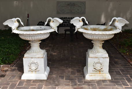
Sold2023FINE PAIR OF CAST IRON SWAN HANDLE GARDEN URNSON PEDESTAL The reeded classical campagna form urns each with a pair of opposing swan handles with outspread wings. The urns set atop a fine pair of wreath decorated square pedestals with stepped footSee Sold Price
Sold2023CHINESE SIX PANEL JADE, HARDSTONE & CLOISSONE SCREENA magnificent Chinese six panel lacquered hardstone, jade and cloissone overlaid carved wood & laquered screen. Qing Dynasty. Comprising three pairs of screen panels each with overlaid jade and hardstSee Sold Price
Sold202310' 8" x 17' 8" LAVER KIRMANAn excellent quality antique Laver Kirman Carpet 10' 8" x 17'8" the red field with central medallion, exceptional design and execution.See Sold Price
Jun 13Swann Auction Galleries(COLONIAL NORTH AMERICA -- MIDDLE ATLANTIC.) Johann Baptist Homann. Virginia Marylandia et Carolina$500
3 days LeftLeon GalleryJodocus Hondius 1606 (Jodocus Hondius and Cornelis Claesz) - India Orientalis₱40,000
Jun 13Swann Auction Galleries(ATLANTIC -- NEW WORLD.) Laurent Fries; after Martin Waldseemuller. Oceani Ocidentalis seu Terre$3,800
4 days LeftSimpson Galleries, LLC.JODOCUS HONDIUS (1563-1612) A JACOBEAN MAP, "Northamptonshire," AMSTERDAM, 1610$150
Jun 18DOYLE Auctioneers & AppraisersA block puzzle with maps of Europe, England, Ireland, Scotland, America and the World$100
4 days LeftEarly American History Auctions1776 Map, PARTIE ORIENTALE DU CANADA, AVEC LA NOUVELLE ANGLETERRE, L'ACADIE... by P. Santini, Framed$950
Jun 13Swann Auction Galleries(NEW JERSEY.) Group of 3 mid-nineteenth-century wall maps of Garden State counties.$900
Jun 13Swann Auction Galleries(NEW JERSEY.) Group of 2 mid-nineteenth-century wall maps of Garden State counties.$600
1 day LeftJasper52World War 2 Europe Battle of the Atlantic 1939-43 Axis Expansion limits 1959 map$15


![[MAP]. HOMANN, Johann Baptist (1663-1724). Virginia, Marylandia et Carolina in America: [MAP]. HOMANN, Johann Baptist (1663-1724). Virginia, Marylandia et Carolina in America Septentrionali. Nuremberg, [ca 1714].   Engraved map of the Mid-Atlantic with hand-coloring in wash and outl](https://p1.liveauctioneers.com/197/243556/126318973_1_x.jpg?height=310&quality=70&version=1649293172)


![French Map of America Southeast [179304] (1 of 1)](https://p1.liveauctioneers.com/2699/331495/178785746_1_x.jpg?height=282&quality=70&version=1717094933)


