Sold2022Frank Mason (1875-1965) SS City of Benares City and Hall Lines To & From Egypt India Ceylon, (SuezFrank Mason (1875-1965) SS City of Benares City and Hall Lines To & From Egypt India Ceylon, (Suez Canal Ferdinand de Lesseps statue in the background) original poster printed by S Straker c. 1936 - 1See Sold Price
Sold2023116 stereoviews of India, Ceylon, Burma, Siam.116 stereoviews of India, Ceylon, Burma, Siam.See Sold Price
Sold2017Tardieu: Antique Map of Southern India & Ceylon, 1795Title/Content of Map: 'Inde Partie Meridionale de la Presqu'isle en deca du Gange' A map of Southern India and Ceylon (Sri Lanka), including the Laccadives and northern Maldives. Mentelle/Chanlaire. ISee Sold Price
Sold2021Group of Stamps - India, Ceylon and PakistanStock book full with stamps from India, Ceylon and Pakistan. This sale will be broadcast live on sale day with an auctioneer and caller calling full descriptions of each lot being sold, as well as vidSee Sold Price
Sold2021Mixed Coins from India, Ceylon, Pakistan, Etc.Box Lot of Mixed Coins from India, Ceylon, Pakistan, Etc. -See Sold Price
Sold2021c1750 Engraved Map of Southern India CeylonA map by Jacques Bellin circa 1750 entitled "Suite de la Carte de L' Indoustan..", showing the southern part of Inida including Bombay with island of Ceylan off coast. Printed in Paris. Fold as issuedSee Sold Price
Sold2018South India Ceylon Burma Straits Settlements SingaporeTITLE/CONTENT OF MAP: 'India (Southern Sheet) [inset: South-eastern provinces of India (Hindu-Chinese countries of Further India)]' DATE PRINTED: 1879 IMAGE SIZE: Approx 47.0 x 60.0cm, 18.5 x 23.75 inSee Sold Price
Sold2017Bonne: Map of South India Ceylon Maldives, 1780Title/Content of Map: 'Carte de la Partie Inferieure de l' Inde en deça du Gange' The map covers south India including the Malabar and Coromandel coasts, Sri Lanka/Ceylon, The Laccadives, the MaldiveSee Sold Price
Sold2023THE SHETLAND ISLANDS antique map by GW BACON Scotland 1885 oldTITLE/CONTENT OF MAP: 'The Shetland Islands' DATE PRINTED: 1885 IMAGE SIZE: Approx 33.0 x 24.0cm, 13 x 9.5 inches (Large); Please note that this is a folding map. TYPE: Colour Antique Lithograph Map CSee Sold Price
Sold2022Powell, Last Home of Mystery 1929 Nepal, India, Ceylon ++ illustrated"The Last Home of Mystery. Adventures in Nepal together with accounts of Ceylon, British India, the Native States, the Persian Gulf, the Overland Desert Mail and the Baghdad Railway". Illustrated withSee Sold Price
Sold2019Barclay, James 1809 Antique Map. India & Ceylon"Hindoostan with the Island of Ceylon, Maldives &c &c" Outline Hand Coloured Copper Engraved Map Published 1809, Leeds for "Barclay's Complete and Universal Dictionary of the English Language..." by tSee Sold Price
Sold2018Bryce, James 1881 Map of Madras. India & CeylonLithograph Map Published 1881, London for ""The International Atlas and Geography..." by James Bryce. Maps by Edward Weller & John Bartholomew. Uncommon. Paper Size: 18 x 13 inch (46 x 33cm) Good CondSee Sold Price
Sold2024Barclay, James 1808 Antique Map. India, Ceylon & Maldives"Hindoostan with the Islands of Ceylon, Maldivas &c &c." Copper Engraved Map Published 1806, London for "Barclay's Complete and Universal English Dictionary" by the Rev. James Barclay. Paper Size: 10See Sold Price
Sold2018India & Ceylon 1750's Map by Bolton, Bowen & d'Anville"Asia, plate 4" Showing India & Ceylon by Solomon Bolton, after d'Anville's earlier map. One sheet only (of 4) Engraved by E. Bowen. Published 1751-57, London for "The Universal Dictionary of Trade anSee Sold Price
Sold202318th C. Indo-Portuguese Ivory Statuette of MarySouth Asia, western India, Ceylon (modern-day Sri Lanka) or Goa, Indo-Portuguese culture, ca. 18th century CE. A beautiful ivory carving of the Virgin of the Immaculate Conception depicted draped in lSee Sold Price
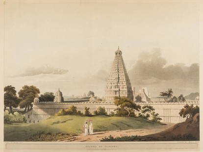
Sold2017India and the Middle East.- Salt (Henry) Pagoda atIndia and the Middle East.- Salt (Henry) Pagoda at Tanjore; The Pass of Atbara in Abyssinia, both from: 'Twenty-Four Views in St Helena, The Cape, India, Ceylon, The Red Sea, Abyssinia and Egypt', aquSee Sold Price
Sold2022Cholera.- Kennedy (James) The History of the Contagious Cholera..., , first edition, 1831 & othersCholera.- Kennedy (James) The History of the Contagious Cholera..., 2 folding engraved maps of India & Ceylon and Asia & Europe, library cloth, 1831 § Boisseau (François Gabriel) TraitéSee Sold Price
Sold2020Henry Salt,(British 1780-1827)Henry Salt,(British 1780-1827) View of Grand Cairo and The Pyramids of Cairo (two prints) from Twenty-four Views in St. Helena, the Cape, India, Ceylon, the Red Sea, Abyssinia and Egypt Drawn by HenrySee Sold Price
Sold2022World Stereographic Photography Collection (6 groups)Lot of over 150 stereographic photo pairs (stereograph cards) grouped into 6 boxed sets, each box representing a different part of the world. Groups are: Philippines, India & Ceylon, Eastern Canada, MSee Sold Price
Sold2017Miniature, Vintage Iron Base Globe ExcelsiorGW Bacon Excelsior Globe Measures approx. 13” tall x 7.75” across the baseSee Sold Price
Sold2019Road-Map of England And WalesTitle: Road-Map of England And Wales Publication Date: 1835-03-25 Cartographer: BACON, G. W. & CO. Publisher: G.W. BACON & CO. Dimension: 33Height - 26.5Width Retailed by Forster Groom & Co. Ltd. DissSee Sold Price
Sold2023[MAP] TACHARD, G. CARTE MARINE [INDIA, ETC.] 1701Tachard Guy. CARTE MARINE Depius Suratte jusqu'au Detroit de Malaca Dressee par le R.P. Tachard de la Compangnie de Jesus... Paris: I.B. Nolin [Jean-Baptiste Nolin], 1701. Map showing India, Ceylon (SSee Sold Price
Sold2017Maldives, Male, Atolls, Sri Lanka Map, Mallet, 1683TITLE OF THE MAP: 'Isles des Maldives' The map includes Southern India & Ceylon (Sri Lanka) as well as the Maldive Islands. The cartouche is particulary attractive. DATE PRINTED: 1683 IMAGE SIZE: ApprSee Sold Price
Sold2018CIRCA 1930 TERRESTRIAL FLOOR GLOBEA terrestrial floor globe on mahogany stand and meridional ring, marked "G.W. Bacon 12" for George Washington Bacon & Co. Ltd, circa 1930, condition noted, missing May and June, 44 inches tall.See Sold Price
Featured19 hrs LeftJasper52CENTRAL AFRICA. French Congo German east British Angola Tanzania. BACON 1893 map$15
BonhamsCRICKET - LORD HAWKE'S TOUR OF INDIA AND CEYLON, 1892-3 Album of 87 photographs of Lord Hawke's ...£2,000
1 day LeftKey Date CoinsSmall Cent Mixed Roll Orig Brandt McDonalds Wrapper, 1919-p Lincoln Wheat end, 1894 Indian other$35
4 days LeftMynt AuctionsLa Reine by Reed and Barton Sterling Silver Salad Serving Fork GW Dated 1894$10


![South India Ceylon Burma Straits Settlements Singapore: TITLE/CONTENT OF MAP: 'India (Southern Sheet) [inset: South-eastern provinces of India (Hindu-Chinese countries of Further India)]' DATE PRINTED: 1879 IMAGE SIZE: Approx 47.0 x 60.0cm, 18.5 x 23.75 in](https://p1.liveauctioneers.com/5584/120928/61572048_1_x.jpg?height=310&quality=70&version=1524615138)


![[MAP] TACHARD, G. CARTE MARINE [INDIA, ETC.] 1701: Tachard Guy. CARTE MARINE Depius Suratte jusqu'au Detroit de Malaca Dressee par le R.P. Tachard de la Compangnie de Jesus... Paris: I.B. Nolin [Jean-Baptiste Nolin], 1701. Map showing India, Ceylon (S](https://p1.liveauctioneers.com/8124/310027/165853627_1_x.jpg?height=310&quality=70&version=1700184289)


