Sold2023[MAP] TACHARD, G. CARTE MARINE [INDIA, ETC.] 1701Tachard Guy. CARTE MARINE Depius Suratte jusqu'au Detroit de Malaca Dressee par le R.P. Tachard de la Compangnie de Jesus... Paris: I.B. Nolin [Jean-Baptiste Nolin], 1701. Map showing India, Ceylon (SSee Sold Price
Sold20221745 Delisle Map of India -- Carte des Cotes de Malabar et de CoromandelTitle: 1745 Delisle Map of India -- Carte des Cotes de Malabar et de Coromandel Cartographer: G Delisle Year / Place: 1745, Paris Map Dimension (in.): 17.5x23 in. This is a superb large map of southerSee Sold Price
Sold2017Depot de la Marine: Antique Map of Gulf of Mexico, 1800Map: Carte des Côtes du Golfe du Mexique Cartographer: Collin/Besançon/Dépôt Général de la Marine/ Place & Date: Paris / 1800 (Year IX) Size: 35 5/8" x 23 3/4" Condition: b&w; a beautifully presSee Sold Price
Sold2022MAP, World, BellinWorld. Jacques Nicolas Bellin, Carte Reduite des Parties Connues du Globe Terrestre Dressee au Depost des Cartes Plans et Journaux de la Marine..., 1755 (dated). Hand Color. This is the rare first ediSee Sold Price
Sold2021A COLONIAL MAP, "Carte de la Louisiane et du Cours duA COLONIAL MAP, "Carte de la Louisiane et du Cours du Mississipi," PARIS, JUNE 1718, hand colored engraving on paper, "Dressée sur un grand nombre de Mémoires entr'autres sur ceux de Mr. le Maire paSee Sold Price
Sold2017THOMAS HART BENTON LETTER, HAND DRAWN MAP, ETCAutographs, drawing, photos and ephemera from the estate of Kansas City writer and photographer Bob Barrett (1943- 2016) relating to his personal experience with Kansas City artist Thomas Hart BentonSee Sold Price
Sold2022(129 Pc) B And G Marine Themed Porcelain Tableware SetDESCRIPTION: B & G marine themed 129 piece porcelain tableware set featuring plates, teacups, serving dishes, candlesticks, and other vessels. Each piece is decorated with a blue gradient glaze. MostSee Sold Price
Sold2016GUILLAUME DELISLE (FRENCH 1675-1726), DOUBLE-PAGEGUILLAUME DELISLE (FRENCH 1675-1726), DOUBLE-PAGE ENGRAVED MAP, "CARTE DE LA LOUISIANE ET DU COURS DU MISSISSIPI", PARIS 1718, SECOND STATE. SIGHT 20 X 26"; FRAMED 26 3/4 X 32 3/4"See Sold Price
Sold2019Carte réduite des Terres Australes'. Pre-Cook AustraliaTITLE/CONTENT OF MAP: 'Carte réduite des Terres Australes [Reduced map of Terra Australis]' DATE PRINTED: 1753 IMAGE SIZE: Approx 21.5 x 29.0cm, 8.25 x 11.5 inches (Large); Please note that this is aSee Sold Price
Sold2022Aldro T. Hibbard Personal Materials, EphemeraPersonal material belonging to Aldro T. Hibbard (1886-1972), including family bible, slides of his paintings, photos, maps, etc.See Sold Price
Sold2022[STREETER COPY] SEARCY, I. G. Map of Florida constructed principally from authentic documents in the[STREETER COPY] SEARCY, I. G. Map of Florida constructed principally from authentic documents in the Land office at Tallahassee by I. G. Percy. Published by I.G. Searcy Tallahassee & F. Lucas Jr., BalSee Sold Price
Sold20201802 Denon Atlas of Egypt Containing Maps, Views, etc.Title: 1802 Denon Atlas of Egypt Containing Maps, Views, etc. -- Planches du voyage dans la Basse et la Haute Egypte Date: 1802 c., Paris Cartographer: D-V Denon Size: 18.2 X 11.4 in. and lagest foldoSee Sold Price
Sold2017Aldina - Aratus Solensis[Scriptores astronomici] Venezia, Aldo Manuzio, ottobre 1499. In 2°. Solo 39 (di 376) carte (G-I10, K9) relative ai Phaenomena di Arato, illustrazioni xilografiche nel testo, qualche fioritura e pochSee Sold Price
Sold2022(PICTORIAL MAPS.) John Diakoff; G. Primakoff; and P. Sergeeff. Map of China.(PICTORIAL MAPS.) John Diakoff; G. Primakoff; and P. Sergeeff. Map of China. Enormous chromolithographed map of China with profuse pictorial illustration, inset charts, reference tables, and scenic viSee Sold Price
Sold2020G. C. Black Marine Box ChronometerAmerican. 1850s. Marine chronometer on gimbals in rosewood three decker box having brass trim pieces. Silvered metal dial with black Roman numerals. Fifty-six hour marine chronometer movement. Dial siSee Sold Price
Sold2023Mercator, America Sive India Nova Map, 17th century"America Sive India Nova..." hand colored. Dimensions:Sight is 15" x 18 1/2", the frame 21" x 24 1/2". Provenance:From a Philadelphia Collection.See Sold Price
Sold2015Vintage PostersK I Nixon (Kathleen Irene 1894-1988) Travancore See India, printed for the Government of India by G Claridge Bombay c.1930 - 102 x 63 cmSee Sold Price
Sold2021Antique French Map of MississippiAntique French Map of Mississippi , "Carte Geographique, Statistique et Historique du Mississipi", Paris, Buchon, 1825, sight 21 in. x 27 1/2 in., framed Provenance: Estate of Julia Evans ReedSee Sold Price
Sold202119TH C. PHOTOGRAPHS, TINTYPES, CDV'S, ETC.Large19TH C. PHOTOGRAPHS, TINTYPES, CDV'S, ETC.Large collection of 19th c. photographs, 3 albums, daguerreotypes, tintypes, ambrotypes, carte de visites, etc., of the Knight and Merrill families, includingSee Sold Price
Sold20231874 Colton's General AtlasNew York,1874 "Colton's General Atlas with Descriptions" with maps drawn by G. Woolworth Colton, descriptions by Richard Swainson Fisher, published by G.W. & C. B. Colton & Co. in 1874. Print on paperSee Sold Price
Sold2022G. TAIT. Kedarnath / See India. [Bombay: Bolton Fine Art Of...G. TAIT. Kedarnath / See India. [Bombay: Bolton Fine Art Offset Litho], ca. 1930s. Color lithograph tourism poster depicting Kedarnath Temple, in the Himalayas, near one of the tributaries of the RSee Sold Price
Sold2018India.- Joseph (Charles) Map of the Grand Trunk RoadIndia.- Joseph (Charles) Map of the Grand Trunk Road from the Karamnassa to the Sutledge, Part Second, from Agra to Ferozepoor, large folding road map of one of the oldest and longest trade routes linSee Sold Price
Sold2016The Kingdom of ChinaJohn Speed (1552-1629). Copperplate Engraved Map. Abraham Goos & John Speed: 1627. 17 1/4 x 21 1/2 inches. This superb map of China, Korea and Japan is the only carte-a-figures map made of the region.See Sold Price
Sold2021MAP, Western Hemisphere, BlaeuBlaeu's Stunning Carte-a-Figures Map of the Americas in Full Contemporary Color. Western Hemisphere - America. Willem Blaeu, Americae Nova Tabula, 1642 (circa). Hand Color. This stunning carte-a-figurSee Sold Price
5 days LeftJasper521792 Elwe Map of Holland -- Carte Generale des Provinces Unies des Pais Bas et Terres Voisines?$80
May 10Hermann Historica GmbH"Operation Chariot" - a military map of the 22nd Naval Flak Regiment, March 27/28, 1942€720
May 12Hoch LTD.Six Vintage G-Man FBI Games Incl. Melvin Purvis, Parker Brothers, Milton Bradley, Whitman Publishing$50(1 bid)
May 18Ni-Cola Classics - Automobilia Auction & Classic Car SalesZagato 46-parts Zagato from the 80s/90s€70
May 17Ni-Cola Classics - Automobilia Auction & Classic Car SalesAlfa Romeo 17x model car in scale 1:16 / 1/18 / 1:14€300
May 12Hoch LTD.Eighteen Silver Reference Books, Sterling Silver, American Silversmiths, Philadelphia, Maryland,$50(1 bid)
4 days LeftHudson Valley Auctioneers LLC Beacon NYLarge vintage toy lot, G.I. Joe figures and accessories, including a chest with clothing, guns etc.$160(6 bids)
May 14Fleischer's Auctions1755 Map Partie de l'Amerique Septentrionale, qui comprend Le Cours de L'Ohio...$200(3 bids)
4 days LeftWinter Associates RAILROAD: Accucraft G Scale Rio Grande K-27 "Mudhen" outdoor locomotive and tender, engine #463,$950(3 bids)
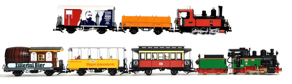
4 days LeftWinter Associates RAILROAD: Seven LGB European themed G Scale outdoor locomotives and train cars, German, 20th C.,$250(3 bids)
4 days LeftWinter Associates RAILROAD: Set of seven G Scale outdoor locomotive and train cars, made by Bachmann and$250(2 bids)


![[MAP] TACHARD, G. CARTE MARINE [INDIA, ETC.] 1701: Tachard Guy. CARTE MARINE Depius Suratte jusqu'au Detroit de Malaca Dressee par le R.P. Tachard de la Compangnie de Jesus... Paris: I.B. Nolin [Jean-Baptiste Nolin], 1701. Map showing India, Ceylon (S](https://p1.liveauctioneers.com/8124/310027/165853627_1_x.jpg?height=310&quality=70&version=1700184289)


![[MAP] TACHARD, G. CARTE MARINE [INDIA, ETC.] 1701 First Image](https://p1.liveauctioneers.com/8124/310027/165853627_1_x.jpg?height=300&quality=1&version=1700184289&width=300)
![[MAP] TACHARD, G. CARTE MARINE [INDIA, ETC.] 1701 First Image](https://p1.liveauctioneers.com/8124/310027/165853627_1_x.jpg?height=300&quality=95&version=1700184289&width=300)


![Carte réduite des Terres Australes'. Pre-Cook Australia: TITLE/CONTENT OF MAP: 'Carte réduite des Terres Australes [Reduced map of Terra Australis]' DATE PRINTED: 1753 IMAGE SIZE: Approx 21.5 x 29.0cm, 8.25 x 11.5 inches (Large); Please note that this is a](https://p1.liveauctioneers.com/5584/156033/78749910_1_x.jpg?height=310&quality=70&version=1575421548)

![[STREETER COPY] SEARCY, I. G. Map of Florida constructed principally from authentic documents in the: [STREETER COPY] SEARCY, I. G. Map of Florida constructed principally from authentic documents in the Land office at Tallahassee by I. G. Percy. Published by I.G. Searcy Tallahassee & F. Lucas Jr., Bal](https://p1.liveauctioneers.com/292/250642/130213737_1_x.jpg?height=310&quality=70&version=1654271664)

![Aldina - Aratus Solensis: [Scriptores astronomici] Venezia, Aldo Manuzio, ottobre 1499. In 2°. Solo 39 (di 376) carte (G-I10, K9) relative ai Phaenomena di Arato, illustrazioni xilografiche nel testo, qualche fioritura e poch](https://p1.liveauctioneers.com/676/104473/53505376_1_x.jpg?height=310&quality=70&version=1495797311)


![G. TAIT. Kedarnath / See India. [Bombay: Bolton Fine Art Of...: G. TAIT. Kedarnath / See India. [Bombay: Bolton Fine Art Offset Litho], ca. 1930s. Color lithograph tourism poster depicting Kedarnath Temple, in the Himalayas, near one of the tributaries of the R](https://p1.liveauctioneers.com/928/255324/132835944_1_x.jpg?height=310&quality=70&version=1658268357)