Sold2023Book: Captain James Cook Charts & Views, R.A. Skelton Edition, Hakluy Society, Cambridge 1969.Book: Captain James Cook Charts & Views, R.A. Skelton Edition, Hakluy Society, Cambridge 1969.See Sold Price
Sold2024James Cook - Map / Chart Of The Island TahitiEngraved nautical map from the 1774 first French edition of the first map of New Zealand, illustrating Lieutenant James Cook's 1769 exploration of the passage between New Zealand's North and South islSee Sold Price
Sold2017Cook, James. Chart of the Sandwich Islands(London: Nicol & Cadel, 1784-85), copperplate engraving showing the Hawaiian Islands with a detailed inset of Karakakooa Bay, site of Captain Cook's demise. Cook and Lieutenant Henry Roberts are officSee Sold Price
Sold2018World chart with discoveries of James Cook 1787Heading: Author: Faden, William Title: A New General Chart of the World, Exhibiting the Whole of the Discoveries made by the late Captain James Cook, F.R.S. with the Tracks of the Ships under his ComSee Sold Price
Sold2020James Cook, Surveyor of Newfoundland 1965 1/365Heading: (Cook, James) Author: Skelton, R.A., intro. Title: James Cook, Surveyor of Newfoundland: Being a Collection of Charts of the Coasts of Newfoundland and Labradore, &c. Drawn from Original SurvSee Sold Price
Sold2024Entrée de Norton & Détroit de Bhering. Bering Strait Norton Sound BONNE 1790 mapTITLE/CONTENT OF MAP: [Cook 3e Voyage] Carte de l'entrée de Norton et du Détroit de Bhering, où l'on voit le Cap le plus Oriental de l'Asie et la pointe la plus Occidentale de l'AméSee Sold Price
Sold2023World: Captain Cook, Large Folio - A General Chart Exhibiting the Discoveries made by Captain JamesThis fascinating folio engraving is from Captain James Cook & James King's A Voyage to the Pacific Ocean, for making Discoveries in the Northern Hemisphere. To determine the Position and Extent of theSee Sold Price
Sold2023James Cook Antiquated MapAntiquated framed and glazed map / 'agenera chart' depicting the voyages and discoveries of Captain James Cook height 28 in. x width 42 in. x depth 1.5 in. We happily provide seamless shippiSee Sold Price
Sold2018Antique Chart of the Island of Tahiti, 1775Title/Content of Map: Chart of the Island of Otaheite Date Printed: 1775 ca. Cartographer: Capt. James Cook R.N. Size (inches): 12.3x16.1 Large scale map of the Island of Tahiti, with detailed typograSee Sold Price
Sold2017Polar Regions Arctic/Antarctic Sea Chart, 1914Title/Content of Map: 'The Polar Regions; Arctic Regions; Antarctic Regions; Inset Greenland; Spitzbergen; The Bering Strait and Lower Yukon; Weddell Sea; Ross Sea' This map is folding hence the centrSee Sold Price
Sold2016James Cook, Carte Des Decouvertes Mer PacifiqueAn engraved map / chart of the Pacific Islands, Carte Des Decouvertes faites dans la Mer Pacifique, Commande par le Capitaine Cook, en 1774. Authored by Captain James Cook in 1774, with Nouvelle CaledSee Sold Price
Sold2024Alaska History Book Pair [174432]1886 Bancroft's Works Vol XXXIII, History of Alaska, 1730-1885. Russia, Bering Strait, French interest etc, 775pp with index-both boards detaching. 1938 Old Yukon, Tales-Trails-Trials by James WickersSee Sold Price
Sold2024Map of New Zealand Print from 1772 RecordThorndon Fine Prints (Wellington, New Zealand) reprodcued this chart of the 1772 record of New Zealand, which was compiled by Lieutenant James Cook Commander of the Endeavor, using the running surveySee Sold Price
Sold2022c. 1781 Captain Cook Voyages Map, London by Alexander HoggHistoric Maps "A Plan of Success Bay in Strait Le Maire / A Chart of the S.E. part of Terra del Fuego... by Captn. Cook 1769" c. 1781, A "Dual" Map from Captain Cook's Voyages, titled: "A Plan of SuccSee Sold Price
Sold2022c. 1781 Captain Cook Voyages Map, London by Alexander HoggHistoric Maps "A Plan of Success Bay in Strait Le Maire / A Chart of the S.E. part of Terra del Fuego... by Captn. Cook 1769" c. 1781, Dual Map from Captain Cook's Voyages, titled: "A Plan of SuccessSee Sold Price
Sold20241795-1803 JAMES COOK TRAVELS 13 VOLUMES ILLUSTRATED w/ 200 ENGRAVINGS antiqueREIZEN RONDOM DE WAERELD, door JAMES COOK, vertaald door J.D.PASTEUR (Translated by J.D. Pasteur) Leyden, Amsterdam and The Hague, Honkoop Allart and Van Cleef, 1795-1803 First edition in Dutch LanguaSee Sold Price
Sold20221774-1792 18 VOLUMES THREE VOYAGES of CAPTAIN JAMES COOK antiqueBeautiful copy, in luxury bindings, complete with the three voyages of Captain Cook in 18 octavo volumes. The first and the third voyage is first octavo edition, respectively from 1774 & 1785. The secSee Sold Price
Sold20231784 JAMES COOK VOYAGE TO PACIGIC OCEAN 4 VOLUMES antique in ENGLISH ILLUSTRATEDCook, J. and King, J. A Voyage to the Pacific Ocean; Undertaken by Command of his Majesty, for making Discoveries in the Northern Hemishere: Performed under the Direction of Captains Cook, Clerke, andSee Sold Price
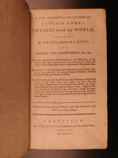
Sold20211784 CAPTAIN JAMES COOK VOYAGES AROUND THE WORLD 150[COOKS VOYAGES] First Edition. A New, Authentic, and Complete Collection of Voyages Round the World. Undertaken and Performed by Royal Authority. Containing an Authentic, Entertaining, Full and CompleSee Sold Price
Sold20221784 JAMES COOK 2 VOLUMES Voyage towards South Pole & round the World antiqueCook (James). A Voyage towards the South Pole, and round the World London: Strahan & Cadell, 1784 portrait frontispiece to volume 1, 56 engraved plates (7 additional plates supplied in facsimile incluSee Sold Price
Sold2022COOK, JAMES The Three Voyages of Captain James Cook Round the World.COOK, JAMES The Three Voyages of Captain James Cook Round the World. London: Longman, Hurst, Rees, Orme, and Brown, 1821. Seven volumes in period brown calf, rebacked to style, all edges marbled. 8 5/See Sold Price
Sold2023"A Voyage Towards the South Pole..." by James CookSet of two volumes (Third Edition dated 1779) comprising the entirety of "A Voyage Towards the South Pole, and Round the World. Performed in His Majesty's Ships the Resolution and Adventure, in the YeSee Sold Price
Sold20191786 VERY RARE Voyages of Captain James Cook Hawaii1786 VERY RARE Voyages of Captain James Cook Hawaii Pacific Australia New Zealand “Remember, the greater the opportunity, the fewer are those who see it.” – James Cook James Cook was an 18th-cenSee Sold Price
Sold2021Half Dollar USA 1928 Hawaii James Cook1/2 Dollar USA. 1928. Hawaii. James Cook. 1778-1928. The original invoice from the purchase of the coin is available.See Sold Price
3 days LeftJasper52Entrée de Norton & Détroit de Bhering. Bering Strait Norton Sound BONNE 1788 map$30
5 days LeftTrillium Antique Prints & Rare BooksCaptain Cook, Large Folio - Chart of the New Coast of America and New Coast of Asia$100
5 days LeftTrillium Antique Prints & Rare BooksCaptain Cook, Large Folio - A General Chart: Exhibiting the Discoveries made by Captain James Cook$200
7 days LeftSchilb Antiquarian Rare Books1786 Voyages James Cook New Zealand Tahiti Palestine Palmyra Temple SYRIA 4v$115(7 bids)
3 days LeftJasper52PACIFIC.Spencer S Vincent Tasmania Bering British Columbia Puget river 1971 map$15
Jun 29Thomaston Place Auction GalleriesBINDER (APPROX 75) EARLY SHIPPING DOCUMENTS & CORRESPONDENCE$150
BonhamsGOLDEN COCKEREL PRESS LAWRENCE (T.E.) Secret Despatches from Arabia, The Golden Cockerel Press (8)£600(1 bid)
2 days LeftChurchill GalleriesFrancis Skeet: The Life of the Right Honorable James Radcliffe. 1929 ed$10
3 days LeftJasper52South Pacific Ocean. French Polynesia Cook Islands. US Navy sea chart 1895 map$140


![Entrée de Norton & Détroit de Bhering. Bering Strait Norton Sound BONNE 1790 map: TITLE/CONTENT OF MAP: [Cook 3e Voyage] Carte de l'entrée de Norton et du Détroit de Bhering, où l'on voit le Cap le plus Oriental de l'Asie et la pointe la plus Occidentale de l'Amé](https://p1.liveauctioneers.com/5584/326888/175994368_1_x.jpg?height=310&quality=70&version=1713903186)


![Alaska History Book Pair [174432]: 1886 Bancroft's Works Vol XXXIII, History of Alaska, 1730-1885. Russia, Bering Strait, French interest etc, 775pp with index-both boards detaching. 1938 Old Yukon, Tales-Trails-Trials by James Wickers](https://p1.liveauctioneers.com/2699/324080/174413284_1_x.jpg?height=310&quality=70&version=1711485545)


![1784 CAPTAIN JAMES COOK VOYAGES AROUND THE WORLD 150: [COOKS VOYAGES] First Edition. A New, Authentic, and Complete Collection of Voyages Round the World. Undertaken and Performed by Royal Authority. Containing an Authentic, Entertaining, Full and Comple](https://p1.liveauctioneers.com/5584/216935/111250719_1_x.jpg?height=310&quality=70&version=1631047725)