Sold2018Jansson: Magellan Straits/Tierra del FuegoReserve Reduced! Map Title: Tabula Magellanica Qua Tierrae del Fuego Cartographer: Jansson Place / Date: Amsterdam / 1640 Size: 21 1/4" x 16 3/8" Condition: full color; centerfold repaired and reinforSee Sold Price
Sold2023GROUP OF 5 HAND COLORED MAPS OF THE AMERICASGroups of five hand colored antique maps of the Americas, comprising "America Merioio-Nalis (South American)" circa 1620, "Tabula Magellanica Qua Tierre Del Fuego (Strait of Magellan)" circa 1640, "IlSee Sold Price
Sold2023Extremité Meridionale de l'Amérique Tierra del Fuego Magellan Str BONNE 1788 map[Cook 2e Voyage] Extremité Meridionale de l'Amérique // Partie Est de la Terre de Feu, le Détroit de Le Maire et partie ouest de la terre des Etats // Canal de Noël // Suite de la CôteSee Sold Price
Sold2020STRAITS of MAGELLAN & TIERRA DEL FUEGO calledTitle: STRAITS of MAGELLAN & TIERRA DEL FUEGO called MAGELLANICA, with Cape Horn Date/Period: 1642-1665 Materials: Copperplate engraved Size: 18 1/4 x 21”. Maps shows the southern most tip of SouthSee Sold Price
Sold2023TWO 17TH CENTURY MAPS OF THE STRAIGHT OF MAGELLANTwo 17th century maps of the Straight of Magellan comprising, "Du Destriot De Magellan," circa 1669 hand colored engraving depicting the lower part of Terra del Fuego, by Gerardus Mercator (Flemish 15See Sold Price
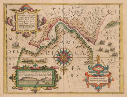
Sold2017Mercator: Strait of Magellan, Terra del Fuego, 1613Exquisita & magno aliquot mensium periculo Lustrata et iam retecta Freti Magellanici Facies . . . By: Gerard Mercator. Date: 1613 / Amsterdam. Dimensions: 14 x 18 inches (35.5 x 45.7 cm) This is an auSee Sold Price
Sold2022MAP, Tierra del Fuego, BlaeuTierra del Fuego. Willem Blaeu, Tabula Magellanica, qua Tierrae del Fuego, cum Celeberrimis Fretis a F. Magellano et I. Le Maire Detectis Novissima et Accuratissima Descriptio Exhibetur, from TheatrumSee Sold Price
Sold2020Hendrik Hondius Map of Tierra del Fuego and StraiHendrik Hondius (1588-1651) "Freti Magellanici ac novi Freti vulgo Le Maire exactissima delineatio," Amsterdam, ca. 1630. This hand colored map depicts the southern tip of South America, featuring TieSee Sold Price
Sold2020Blaeu Map of Tierra del Fuego or Magellanica 1650Willem Janszoon Blaeu (1571-1638), "Tabvla Magellanica qua Tierrae del fuego, cum beleberrimis fretis a F. Magellano et I. Le Maire detectis novissima et accuratissima descriptio exhibetur," AmsterdamSee Sold Price
Sold2021Jansson 1640 Map of the Persian Empire (Iran)DESCRIPTION: Map of Persian Empire during Safavid Dynasty (1501-1736), depicting Caucasus to Indian with the Persian Gulf coastline of the Arabian Peninsula. Includes hundreds of small villages and aSee Sold Price
Sold20211640 Jansson Map of Rhine River Area in Netherlands andTitle: 1640 Jansson Map of Rhine River Area in Netherlands and Germany in Part -- Descriptio Fluminum Rheni, Vahalis et Mosae Cartographer: J Jansson Year / Place: c 1640, Amsterdam Map Dimension (in.See Sold Price
Sold2017Antique Italian Map of Tierra del Fuego, 1750Map: Tierra del Fuogo Cartographer: anonymous Place & Date: Venice / 1750 Size: 9 7/8" x 7 1/4" Condition: some wrinkling, otherwise in beautiful condition A superbly designed and colored MagellanicaSee Sold Price
Sold20221640 Jansson Map of Northern France Centered on Lille -- Flandria Gallica Continens CastellaniasTitle: 1640 Jansson Map of Northern France Centered on Lille -- Flandria Gallica Continens Castellanias Cartographer: J. Jansson Year / Place: 1640 c., Amstedam Map Dimension (in.): 15.6x19.6 in. ThisSee Sold Price
Sold2017Bowen: Map of Chili, Terra Magellanica, Terra del FuegoMap: A New and Accurate Map of Chili, Terra Magellanica. Terra del Fuego Cartographer: Bowen Place & Date: London / 1750 Size: 16 7/8" x 14" Bowen's wonderfully detailed map of southern South AmericaSee Sold Price
Sold2022SOUTH AMERICA. La Plata. Brazil Peru Chile Patagonia Tribes. MALLET 1683 mapTITLE OF THE MAP: 'Païs qui sont aux environs de la riviere de la Plata et du païs des Patagons' (De L'Amerique) The Map runs from Brazil to Tierra del Fuego. DATE PRINTED: 1683 IMAGE SIZE:See Sold Price
Sold2017Mallet: Map of South America, 1683Map Title: 'Païs qui sont aux environs de la riviere de la Plata et du païs des Patagons' SOUTH AMERICA, The Map runs from Brazil to Tierra del Fuego. Brazil Peru Chile Patagonia Tribes Date PrintedSee Sold Price
Sold2024PATAGONIA. Argentina Chile Tierra del Fuego Falklands S Georgia.SDUK 1844 mapCAPTION PRINTED BELOW PICTURE: 'SOUTH AMERICA, SHEET V., PATAGONIA; inset South Georgia, South Shetlands and Orkneys' DATE PRINTED: This map was originally published by The Society for the Diffusion oSee Sold Price
Sold2022Colored engraving L´AMERIQUE MERIDIONALE. Map of AMERICA, from N. Spain to Tierra del Fuego,Colored engraving L´AMERIQUE MERIDIONALE. Map of AMERICA, from N. Spain to Tierra del Fuego, bordered with 12 cartouches without image. Copper engraving by Baeck, according to Jaillot, for his workSee Sold Price
Sold2022c. 1781 Captain Cook Voyages Map, London by Alexander HoggHistoric Maps "A Plan of Success Bay in Strait Le Maire / A Chart of the S.E. part of Terra del Fuego... by Captn. Cook 1769" c. 1781, A "Dual" Map from Captain Cook's Voyages, titled: "A Plan of SuccSee Sold Price
Sold2022c. 1781 Captain Cook Voyages Map, London by Alexander HoggHistoric Maps "A Plan of Success Bay in Strait Le Maire / A Chart of the S.E. part of Terra del Fuego... by Captn. Cook 1769" c. 1781, Dual Map from Captain Cook's Voyages, titled: "A Plan of SuccessSee Sold Price
Sold2019Jansson map of Switzerland c.1640Heading: Author: Jansson, Jan Title: Nova Helvetiae Tabula Place Published: Amsterdam Publisher: Date Published: c.1640 Description: Copper-engraved map, lightly hand-colorSee Sold Price
Sold2016Jansson map of Valois, FranceHeading: Author: Jansson, Jan Title: Valesium Ducatus - Valois Place Published: Amsterdam Publisher: Date Published: c.1640 Description: Copper-engraved map, hand-colored.See Sold Price
Sold20231756 Southern South America, N.E. of Terra Del Fuego at Le Maire Waterway, by G. AnsonTitle: 1756 Southern South America, N.E. of Terra Del Fuego at Le Maire Waterway, by G. Anson Date/Period: 1756 Materials: Copper plate engravedSize: 20 1/2” x 11 ” This 1756 map portraysSee Sold Price
Sold2020PATAGONIA Argentina Chile Tierra del Fuego FalklandsTITLE/CONTENT OF MAP: 'SOUTH AMERICA, SHEET V., PATAGONIA; inset South Georgia, South Shetlands and Orkneys' The top image on the right hand side shows the entire map. To view a close up of the map shSee Sold Price
3 days LeftTremont Auctions17th century original map of Magellan Straights by Mercator and Hondius. 2 sided framing. Overall:$150
5 days LeftJasper521680 Jansson/Duval Map of Middle East -- Tabula Itineris Decies Mille Graecorum sub Cyro Contra$140(1 bid)
May 14Lucas Milano SRLPeter Paul Rubens (Siegen 1577 - Anversa 1640) copia del XIX secolo Marte e Venere Olio su tela 114€1,200
5 days LeftJasper521756 Port Julian, River, and True Justice Island, Patagonia, Argentina Map by G. Anson$25
May 15Aste Bolaffi FILIPPO DE PISIS 1896-1956 L'orologiaio del villaggio 1924 - FILIPPO DE PISIS 1896-1956€20,000
5 days LeftAkiba Galleries(3 Pc) 17th Century Spanish Leather Bound Laws Of The King of Spain$100(1 bid)
May 11Fichter KunsthandelG. MAILE (*1800) after RUBENS (*1577), Self-portrait Rubens, Portrait of an artist, Mezzotint€200
May 14Viscontea Casa d'Aste srlNIKOLAUS VAN HOY (attr.). Painting "THE RAPE OF THE SABINE WOMEN"€4,000


![Extremité Meridionale de l'Amérique Tierra del Fuego Magellan Str BONNE 1788 map: [Cook 2e Voyage] Extremité Meridionale de l'Amérique // Partie Est de la Terre de Feu, le Détroit de Le Maire et partie ouest de la terre des Etats // Canal de Noël // Suite de la Côte](https://p1.liveauctioneers.com/5584/294908/156576945_1_x.jpg?height=310&quality=70&version=1688565030)


![[Maps] Martin Zeiler, Itinerarium Italiae, 1640 (1 of 9)](https://p1.liveauctioneers.com/188/326797/176317459_1_x.jpg?height=282&quality=70&version=1713847031)


