Sold2017Bowen: Map of Chili, Terra Magellanica, Terra del FuegoMap: A New and Accurate Map of Chili, Terra Magellanica. Terra del Fuego Cartographer: Bowen Place & Date: London / 1750 Size: 16 7/8" x 14" Bowen's wonderfully detailed map of southern South AmericaSee Sold Price
Sold2018Morden: Magellanica (Patagonia/Tierra del Fuego)Map Title: Terra Magellanica Cartographer: Morden Place & Date: London / 1680 Size: 4 1/8" x 5" Condition: outline color; light overall age toning; minor spotting Morden's miniature Magellanica map frSee Sold Price
Sold2022c. 1781 Captain Cook Voyages Map, London by Alexander HoggHistoric Maps "A Plan of Success Bay in Strait Le Maire / A Chart of the S.E. part of Terra del Fuego... by Captn. Cook 1769" c. 1781, A "Dual" Map from Captain Cook's Voyages, titled: "A Plan of SuccSee Sold Price
Sold2022c. 1781 Captain Cook Voyages Map, London by Alexander HoggHistoric Maps "A Plan of Success Bay in Strait Le Maire / A Chart of the S.E. part of Terra del Fuego... by Captn. Cook 1769" c. 1781, Dual Map from Captain Cook's Voyages, titled: "A Plan of SuccessSee Sold Price
Sold20231756 Southern South America, N.E. of Terra Del Fuego at Le Maire Waterway, by G. AnsonTitle: 1756 Southern South America, N.E. of Terra Del Fuego at Le Maire Waterway, by G. Anson Date/Period: 1756 Materials: Copper plate engravedSize: 20 1/2” x 11 ” This 1756 map portraysSee Sold Price
Sold20241756 Staten Island, Terra del Fuego, Argentina, by G. AnsonTitle: 1756 Staten Island, Terra del Fuego, Argentina, by G. Anson Date/Period: 1756 Materials:Copper plate engraved Size: 18” x 11 ” Description:This 1756 map provides a prospect of StateSee Sold Price
Sold2023TWO 17TH CENTURY MAPS OF THE STRAIGHT OF MAGELLANTwo 17th century maps of the Straight of Magellan comprising, "Du Destriot De Magellan," circa 1669 hand colored engraving depicting the lower part of Terra del Fuego, by Gerardus Mercator (Flemish 15See Sold Price
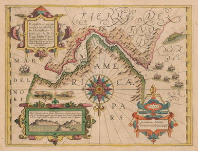
Sold2017Mercator: Strait of Magellan, Terra del Fuego, 1613Exquisita & magno aliquot mensium periculo Lustrata et iam retecta Freti Magellanici Facies . . . By: Gerard Mercator. Date: 1613 / Amsterdam. Dimensions: 14 x 18 inches (35.5 x 45.7 cm) This is an auSee Sold Price
Sold20201802 Handcolored Terre Del Fuego NativesMatted engraving from a work by Johannes Allart, Amsterdam, 1802 entitled "Vuuralnders" natives of Terra Del Fuego, handcolored and engraved by Portman and Kuyper. Fine condition, The print measures 5See Sold Price
Sold2020Blaeu Map of Tierra del Fuego or Magellanica 1650Willem Janszoon Blaeu (1571-1638), "Tabvla Magellanica qua Tierrae del fuego, cum beleberrimis fretis a F. Magellano et I. Le Maire detectis novissima et accuratissima descriptio exhibetur," AmsterdamSee Sold Price
Sold2022MAP, Tierra del Fuego, BlaeuTierra del Fuego. Willem Blaeu, Tabula Magellanica, qua Tierrae del Fuego, cum Celeberrimis Fretis a F. Magellano et I. Le Maire Detectis Novissima et Accuratissima Descriptio Exhibetur, from TheatrumSee Sold Price
Sold2023GROUP OF 5 HAND COLORED MAPS OF THE AMERICASGroups of five hand colored antique maps of the Americas, comprising "America Merioio-Nalis (South American)" circa 1620, "Tabula Magellanica Qua Tierre Del Fuego (Strait of Magellan)" circa 1640, "IlSee Sold Price
Sold2020STRAITS of MAGELLAN & TIERRA DEL FUEGO calledTitle: STRAITS of MAGELLAN & TIERRA DEL FUEGO called MAGELLANICA, with Cape Horn Date/Period: 1642-1665 Materials: Copperplate engraved Size: 18 1/4 x 21”. Maps shows the southern most tip of SouthSee Sold Price
Sold2018Jansson: Magellan Straits/Tierra del FuegoReserve Reduced! Map Title: Tabula Magellanica Qua Tierrae del Fuego Cartographer: Jansson Place / Date: Amsterdam / 1640 Size: 21 1/4" x 16 3/8" Condition: full color; centerfold repaired and reinforSee Sold Price
Sold2021West Indies.- Bowen (Emanuel) A New and Accurate Map ofWest Indies.- Bowen (Emanuel) A New and Accurate Map of Terra Firma and the Caribbe Islands, showing most of the Caribbean from the southern part of Cuba through the Lesser Antilles and the northern pSee Sold Price
Sold2017Antique Italian Map of Tierra del Fuego, 1750Map: Tierra del Fuogo Cartographer: anonymous Place & Date: Venice / 1750 Size: 9 7/8" x 7 1/4" Condition: some wrinkling, otherwise in beautiful condition A superbly designed and colored MagellanicaSee Sold Price
Sold2018Bellin: Patagonia / Magellanica / Falkland Islands 1753Carte Reduite de la Partie la plus Meridionale de l'Amerique Bellin's detailed map of the "southernmost part of America"— Patagonia, Tierra del Fuego, and the Falkland, or Malouine, islands, from thSee Sold Price
Sold2017Bowen: Map of Northern South America / West Indies 1747Map: A New and Accurate Map of Terra Firma and the Caribbe Islands drawn from the most approved Modern Maps & Charts Cartographer: Bowen Place & Date: London / 1747 Size: 16 3/4" x 14" Condition: outlSee Sold Price
Sold2021"Terra FIrma and Caribbe Islands", Emanuel Bowen"A New and Accurate Map of the Terra Firma and the Caribbe Islands", an 18th century map by Emanuel Bowen (1693-1767). An engraved and hand colored map in two pages with central fold crease, framed. 1See Sold Price
Sold2017Coronelli: Mare Del Nord Auttore, 1690Map: Mare Del Nord Auttore IL PM Coronelli … Il Sig Giovanni Grimaldi Savio di Terra Ferma Maker: Coronelli, Vincenzo Date: 1690 Medium: Copperplate engraving Description: An outstanding map by oneSee Sold Price
Sold2020Hendrik Hondius Map of Tierra del Fuego and StraiHendrik Hondius (1588-1651) "Freti Magellanici ac novi Freti vulgo Le Maire exactissima delineatio," Amsterdam, ca. 1630. This hand colored map depicts the southern tip of South America, featuring TieSee Sold Price
Sold2023WILLEM JANSZOON BLAEU Alkmaar (1571) / Amsterdam (1638) "Tabula Magellanica"Hand colored engraving Cartouche on top with full title: TABVLA MAGELLANICA quà Tierrae del fuego, cum celeberrimus fretis a F. Magellano et I. Le Maire detectis novissima et accuraterissima descriSee Sold Price
Sold2022SOUTH AMERICA. La Plata. Brazil Peru Chile Patagonia Tribes. MALLET 1683 mapTITLE OF THE MAP: 'Païs qui sont aux environs de la riviere de la Plata et du païs des Patagons' (De L'Amerique) The Map runs from Brazil to Tierra del Fuego. DATE PRINTED: 1683 IMAGE SIZE:See Sold Price
Sold2017Mallet: Map of South America, 1683Map Title: 'Païs qui sont aux environs de la riviere de la Plata et du païs des Patagons' SOUTH AMERICA, The Map runs from Brazil to Tierra del Fuego. Brazil Peru Chile Patagonia Tribes Date PrintedSee Sold Price
6 days LeftAste Bolaffi ANGELO OSTUNI E RENATO FORTI Lampada da terra ‘399’ per O-Luce 1959 - ANGELO OSTUNI E RENATO€600
2 days LeftTrillium Antique Prints & Rare BooksPtolemy & Magini, pub. 1620 - Map of the Americas$50(1 bid)
2 days LeftTrillium Antique Prints & Rare BooksPtolemy & Magini, pub. 1620 - Map of the World$50(1 bid)
May 14Lucas Milano SRLLeandro Da Ponte, detto Bassano (Bassano del Grappa 1557 - Venezia 1622) Partenza di Abramo verso€2,000
2 days LeftTrillium Antique Prints & Rare BooksPtolemy & Magini, pub. 1620 - Map of the Ancient World with Africa, Europe, Asia$50
2 days LeftTrillium Antique Prints & Rare BooksPtolemy & Magini, pub. 1620 - Map of Taprobana, Island in Sumatra$50
6 days LeftAste Bolaffi ANGELO MANGIAROTTI (ATTRIBUITO) Lampada da terra per Candle anni '60 - ANGELO MANGIAROTTI€700
May 15Aste Bolaffi SALVATORE EMBLEMA 1929-2006 Senza titolo 1989 - SALVATORE EMBLEMA 1929-2006 Untitled 1989€2,400(1 bid)
May 15Aste Bolaffi SALVATORE EMBLEMA 1929-2006 Senza titolo 1982 - SALVATORE EMBLEMA 1929-2006 Untitled 1982€5,000
5 days LeftJasper521764 Bowen Map of West India to Iran -- India As Described By All Authors Before The Fifth Century$80
3 days LeftTremont AuctionsAntique "Chili" map by Blaeu. 2 sided framing. Overall: 18.25 x 21.75in.$50
May 15Aste Bolaffi FILIPPO DE PISIS 1896-1956 L'orologiaio del villaggio 1924 - FILIPPO DE PISIS 1896-1956€20,000