Sold2024Johann Treskot Map Of SiberiaContaining the Provinces of Tobolsk, and YeniseyskSee Sold Price
Sold2018SIBERIA & CHINESE TARTARY Manchuria Mongolia ChinaTITLE/CONTENT OF MAP: 'SIBERIA AND CHINESE TARTARY.' Karakorum the "Ancient Capital of Jenghiz Khan" is marked, along with many of the Silk Routes DATE PRINTED: 1846. This date is printed on the map ISee Sold Price
Sold2019SIBERIA & CHINESE EMPIRE. Manchuria Mongolia Korea NTITLE/CONTENT OF MAP: 'SIBERIA AND CHINESE EMPIRE' DATE PRINTED: 1874 IMAGE SIZE: Approx 34.0 x 42.0cm, 13.25 x 16.5 inches (Large) TYPE: Antique steel engraved map with original outline hand colourinSee Sold Price
Sold2017Bradford: Antique Map of Siberia & Central Asia, 1835Map: Siberia & Central Asia Date Printed: 1835 Cartographer: T.G. Bradford Material/Medium: Paper Size: 13" x 9 1/2" Condition: Very Good. Some foxing on edges. Does not affect Map. Hand colored outliSee Sold Price
Sold2021JOHANN HOMANN, MAP OF NEW ENGLAND, 1720Johann Baptist Homann (German, 1664-1724). "Nova Anglia" - circa 1720, engraving with hand coloring. Approx. 19.5" x 23.125" (sheet)See Sold Price
Sold2015Framed Johann Homann Map Of LondonA Prospect & Street plan of London by Johann Homann Nurnberg 1750, Wychwood Editions reproduction map. Frame: 28" x 32" Image: 21" x 25"See Sold Price
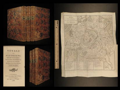
Sold20221788 Voyages Germany MAP Johann Riesbeck Letters Munich Vienna Austria 3v SET1788 Voyages Germany MAP Johann Riesbeck Letters Munich Vienna Austria 3v SET Johann Kaspar Riesbeck was a 18th-century German travel writer best-known for his book Letters from a French traveler in GSee Sold Price
Sold20221764 Bowen Map of Siberia -- An Exact Chart of All the Countries through which Capt. BehringTitle: 1764 Bowen Map of Siberia -- An Exact Chart of All the Countries through which Capt. Behring Travelled from Tobolski Capital of Siberia, to the Country of Kamtschatka Cartographer: E Bowen YearSee Sold Price
Sold2018Map of Siberia and Asian Russia Coloured By Hand 1832Map of Siberia and Asian Russia Coloured By Hand 1832 Lapie Etching On Steel 1832 Lapie M. (Pierre) (1779-1850) etching on steel Leaf Dimension: 66x52 cm (25.98x20.47 inches) Engraving Dimension: 61x4See Sold Price
Sold2022Antique Map: Johann Baptist Homann (1664-1724) GermanSATUUM MAROCCA NORUM, etching with hand-coloring, with center fold as issued, sight 19 x 22”, frame 24 ½ x 27 ½” with glass.See Sold Price
Sold2017Belling: Map of Siberia Russia, 1758Map: 'Carte de la Siberie et des Pays voisins Pour servir à l'Histoire Générale des Voyages par le S. Bellin Ing. de la Marine' A map of Siberia and North Asia, including much of Asiatic Russia, prSee Sold Price
Sold2017Cluver: Antique Map of Siberia from Caspian Sea, 1700Map: 1700 Cluver Map of Siberia from the Caspian Sea -- Scythia et Serica Cartographer: P Cluver Year / Place: 1700 Dimensions: 8 X 12 in. Condition: Excellent. Sharp hand colors on a nice strike. OnlSee Sold Price
Sold2017Malte-Brun: Antique Map of Siberia, 1846Title/Content of Map: 'Sibérie ou Russie d'Asie'. Siberia. Russia in Asia Date Printed: c1846 Image Size: Approx 23.0 x 30.5cm, 9 x 12 inches (Large) Type: Antique engraved map with original outlineSee Sold Price
Sold2021ASIA China Arabia Tartary Siam Persia India EastTITLE/CONTENT OF MAP: 'Asia' States marked on the map include Siberia, Cochin China, China, Hindoostan, Cabool (Kabul), Turkey, Arabia, Persia, Beloochistan, Birmah, Siam, Malaya, Independent Tartary,See Sold Price
Sold2019ASIA. Tartary Siam Persia Cabool Cochinchina EastTITLE/CONTENT OF MAP: 'Asia' States marked on the map include Siberia, Cochin China, China, Hindoostan, Cabool (Kabul), Turkey, Arabia, Persia, Beloochistan, Birmah, Siam, Malaya, Independent Tartary,See Sold Price
Sold2018Tallis/Rapkin: Antique Map of Asia, 1849TITLE/CONTENT OF MAP: 'Asia' States marked on the map include Siberia, Cochin China, China, Hindoostan, Cabool (Kabul), Turkey, Arabia, Persia, Beloochistan, Birmah, Siam, Malaya, Independent Tartary,See Sold Price
Sold2022MAP: Homann, Johann Baptist:MAP: Homann, Johann Baptist: MAP: Homann, Johann Baptist: Prospect Grundris und Gegent der Königl. Schwed. Vestung Stralsund, wie solche den 15 July A. 1715 von den Nordischen Hohen Allyrten istSee Sold Price
Sold2020Eastern Siberia [Includes Kamtchatka]Title/Content of Map: Eastern Siberia [Includes Kamtchatka] Cartographer: WALKER, J. & C./LUTKE/PIADISCHEV Date: 1852 Publisher: CHARLES KNIGHT/GEORGE COX/S.D.U.K. Size: 12.75Height - 15.5Width "PubliSee Sold Price
Sold2022Antique Map of Muscovy & Kingdom of SiberiaAntique Map of Muscovy & Kingdom of Siberia, map reads A CORRECT MAP OF MOSCOVY… THOMAS POWELL of Broadway in Carmarthen Shire.BARONET and KNIGHT of the Shire for the said COUNTRY, measures 29 1See Sold Price
Sold20201798 Map of Russia SiberiaEngraved map of "Siberia or Russian Tartary or Asiatic Russia…", published by W. Faden, London, 1798. Handcolored. Fine, measures 7 x 6". Reserve: $40.00 Shipping: Domestic: Flat-rate of $5.00 to anSee Sold Price
Sold2017SDUK: Antique Map of Central Asia & Siberia, 1846Title/Content of Map: 'WESTERN SIBERIA, INDEPENDENT TARTARY, KHIVA, BOKHARA &c' Date Printed: 1846 Image Size: Approx 42.0 x 34.5cm, 16.5 x 13.75 inches (Large) Type: Antique steel engraved map with oSee Sold Price
Sold2018Bellin: Antique Map of Eastern Siberia, 1740Title/Content of Map: Easter Siberia off Sakhalin Island Date Printed: 1740-70's Cartographer: J.N. Bellin & J.F. La Harpe Material/Medium: Paper Size: 15" x 9 3/4" Copperplate engraved. From the 'AbrSee Sold Price
Sold2024WEST ASIA.Arabia Persia Mesopotamia Russia.Rainfall population density 1920 mapTITLE/CONTENT OF MAP: 'Asia (General); Inset map of Siberia; Mongolia' DATE PRINTED: 1920 IMAGE SIZE: Approx 32.5 x 22.0cm, 12.75 x 8.75 inches (Large) TYPE: Vintage colour map; Scale 1:29,500,000 CONSee Sold Price
Sold2017ALLGEMEINE HISTORIE DER REISEN... 4 Vols. 1747-50.[Books with Maps] [Johann Joachim Schwabe]. ALLGEMEINE HISTORIE DER REISEN ZU WASSER UND LANDE; ODER SAMMLUNG ALLER REISEBESCHREIBUNGEN… 4 Vols only: Vols I-III, VII. Leipzig: by Arkstee und Merkus,See Sold Price
2 days LeftJasper52SIBERIA & CHINESE TARTARY Manchuria Mongolia Korea China East Asia SDUK 1844 map$20
2 days LeftJasper52SIBERIA & CHINESE TARTARY Manchuria Mongolia Korea China Silk road SDUK 1846 map$20
2 days LeftJasper52ASIA. Inset Aden; Isotherms. Persia (Iran) Siam Japan Arabia Siberia &c 1891 map$20
Jun 07Freeman's | HindmanHOMANN, Johann Baptist. Amplissimae Regionis Mississipi Seu Provinciae Ludovicianae. Nuremburg, [ca$400(1 bid)
2 days LeftJasper52MANCHURIA & SOUTH EAST SIBERIA Mongolia China Russia East Asia JOHNSTON 1915 map$30
2 days LeftJasper52South Siberia & Turkestan. Central East Asia. Mongolia China. BAEDEKER 1912 map$40
May 29The Bidder AuctionsJohann Baptista Homann. Terra Sancta Holy Land Map with the Borders of the 12 Tribes of Israel, Hand$100
Featured13 hrs LeftJasper521738 RUSSIA SIBERIA & GREAT TARTARY Description illustrated ANTIQUE in ENGLISH$950
Featured2 days LeftJasper52Les voyages de Rubruquis, Marco Polo, Jenkinson'. BELLIN/SCHLEY 1749 old map$75
2 days LeftForum AuctionsLondon.- Homann (Johann Baptist) Accurater Prospect und Grundris der Konigl: Gros - Britanisch:£500
Featured2 days LeftJasper52SIBERIA AND CHINESE TARTARY. Manchuria Mongolia Korea China. SDUK 1844 old map$20


![Eastern Siberia [Includes Kamtchatka]: Title/Content of Map: Eastern Siberia [Includes Kamtchatka] Cartographer: WALKER, J. & C./LUTKE/PIADISCHEV Date: 1852 Publisher: CHARLES KNIGHT/GEORGE COX/S.D.U.K. Size: 12.75Height - 15.5Width "Publi](https://p1.liveauctioneers.com/5584/171770/86526676_1_x.jpg?height=310&quality=70&version=1592950942)


![ALLGEMEINE HISTORIE DER REISEN... 4 Vols. 1747-50.: [Books with Maps] [Johann Joachim Schwabe]. ALLGEMEINE HISTORIE DER REISEN ZU WASSER UND LANDE; ODER SAMMLUNG ALLER REISEBESCHREIBUNGEN… 4 Vols only: Vols I-III, VII. Leipzig: by Arkstee und Merkus,](https://p1.liveauctioneers.com/179/104231/53361908_1_x.jpg?height=310&quality=70&version=1495213319)


![[MAPS]. A group of 3 engraved maps, most with hand-coloring. (1 of 4)](https://p1.liveauctioneers.com/197/328642/177014805_1_x.jpg?height=282&quality=70&version=1714760103)


