Sold20221862 RR map of Mass., Conn., Rhode Island, MitchellDetailed map of Southern New England, colored by counties and showing towns, railroads, rivers and other details. Shows the railway system in this region in the early years of the Civil War. One of thSee Sold Price
Sold2017Johnson’s Civil War era map of North & South CarolinaHistoric map shows the Carolinas in great detail shortly following the outbreak of the Civil War. States hand-colored at the time of publishing with color coding according to county. Inset map depictsSee Sold Price
Sold2021CIVIL WAR-ERA JOHNSON'S MILITARY MAP UNITED STATESFramed engraving with color on paper, "Johnson's New Military Map of the United States, Showing the Forts, Military Posts & c., with Enlarged Plans of Southern Harbors from Authentic Data Obtained atSee Sold Price
Sold20221882 1st ed CIVIL WAR General Ambrose Burnside Union1882 1st ed CIVIL WAR General Ambrose Burnside Union Army MAPS Rhode Island Ambrose Burnside was a notable American politician and Civil War general from Rhode Island. During the civil war, he led manSee Sold Price
Sold20211882 1st ed CIVIL WAR General Ambrose Burnside Union1882 1st ed CIVIL WAR General Ambrose Burnside Union Army MAPS Rhode Island Ambrose Burnside was a notable American politician and Civil War general from Rhode Island. During the civil war, he led manSee Sold Price
Sold20241862 Civil War-era map of Alabama/Georgia, Johnson & WardJohnson’s Georgia and Alabama from the 1862 edition of Johnson’s Family Atlas published during the second year of the war in 1862 by Johnson & Ward. Shows railroads operating at the beginnSee Sold Price
Sold2023Collection of Obsolete Currency and Ephemera, incl. 1860 Virginia, Civil War, & Rhode IslandGrouping of twenty-three (23) 19th and early 20th-century obsolete currency notes and ephemera, including Civil War-era Southern bills. 1st item: Ten dollar State of Virginia Monticello Bank note, serSee Sold Price
Sold2022Scarce American Civil War era 1864 Dated US Cavalry Soldier's Battle Sword by MANSFIELD & LAMB,Scarce American Civil War era 1864 Dated US Cavalry Soldier's Battle Sword by MANSFIELD & LAMB, Rhode Island. Total length (inside scabbard if present) : 44 1/4", Blade length : 35". ~~ DEAR BIDDERS,See Sold Price
Sold2022Civil War Era Kilingenthal Briquet KnifeGermany, 1816 Slightly curved blade with curved hilt and sturdy handle. Blade 11 1/2".Overall 17 1/4" From the collection of a North Scituate, Rhode Island estate. Blade marked partially illegibly witSee Sold Price
Sold2023Antique Map of Connecticut and Rhode IslandEngraved print map of Connecticut and Rhode Island. Highly detailed revolutionary war era map with towns, roads, rivers, islands, bays and more. Issued: 1776 Dimensions: 10"W x 8"HSee Sold Price
Sold2020Early Civil War era map of AmericaNice example of A. J. Johnson's 1862 map of North America. Presents a fascinating snapshot of North America just after the outbreak of the American Civil War. States generally follow the 1861 configurSee Sold Price
Sold2022Significant United States map, 1864 Johnson & WardVery interesting hand-colored map created at a pivotal time in the settlement of the American West. In this lovely Civil War era map many of the western states have still not settled their borders. ArSee Sold Price
Sold2024Civil War era map of N. America with unsettled state bordersOne of the key maps in the 1860s Johnson series of North America. In this map Idaho Territory encompasses what would eventually become Idaho, Montana and Wyoming. Dakota Territory has yet to split intSee Sold Price
Sold2023Civil War era map of N. America with unsettled state bordersOne of the key maps in the 1860s Johnson series of North America. In this map Dakota Territory has yet to split into its north and south divisions while it stretches to encompass what will eventuallySee Sold Price
Sold2024Scarce Georgia-Alabama Civil War-era RR map by Johnson & Browning, 1861Johnson’s Georgia and Alabama from the scarce 1861 edition of Johnson’s Family Atlas published shortly after the outbreak of the war in 1861 by Johnson & Browning. Shows network of railroaSee Sold Price
Sold2022Civil War era map of N. America with unsettled state bordersOne of the key maps in the 1860s Johnson series of North America. In this map Idaho Territory encompasses what would eventually become Idaho, Montana and Wyoming. Dakota Territory has yet to split intSee Sold Price
Sold202319th century. A hand-colored American Civil War era map of Virginia, Delaware, Maryland, and West19th century. A hand-colored American Civil War era map of Virginia, Delaware, Maryland, and West Virginia. Published by A.J. Johnson New York USA. Marked as page 47. Overall good condition; some browSee Sold Price
Sold2019Civil War Archive incl. Soldier Diary, Ewell SignatureArchive of seven (7) Civil War era items, including letters and diary of William Budlong, Rhode Island 5th Regiment Heavy Artillery, and General R.S. Ewell ALS. 1st item: Original Edition Clayton's OcSee Sold Price
Sold20191860 Holy Bible with Civil War Provenance 11th Infantry1860 Holy Bible with Civil War Provenance 11th Rhode Island Infantry Philo Hawks A rare, Civil War-era, pocket-size New Testament Bible published in 1860 by the American Bible Society. This journal-stSee Sold Price
Sold2019United States. Civil war era military map. ShowingTitle/Content of Map: United States. Civil war era military map. Showing southern ports Date: 1863 Cartographer: By Johnson & Ward. From, Johnson’s New Illustrated Family Atlas Size: 18x 26 1/4”.See Sold Price
Sold202419th C. Johnson’s Florida Map1863 Civil War era colored map of Florida by Alvin Jewett Johnson, published by A.J Johnson New York. Unframed in protective sleeve. Measures just shy of 14 inches by 18 inches.See Sold Price
Sold2023FRAMED 19TH C. JOHNSON'S FLORIDA MAP1863 Civil War Era Colored Map of Florida, by Alvin Jewett Johnson (1827-1884), published by Johnson & Ward, New York, in a gilded and green painted wooden frame with mat, glazed, OS: 19 1/2" x 23 1/2See Sold Price
Sold20181864 Johnson Map of the United States -- Johnson'sTitle/Content of Map: 1864 Johnson Map of the United States -- Johnson's United States Date: 1864, New York Cartographer: A Johnson Size: 16.9 x 23.1 in. This is a large, highly detailed Civil War eraSee Sold Price
Sold2020Johnson's IllinoisTitle/Content of Map: Johnson's Illinois Cartographer: JOHNSON, ALVIN JEWETT Date: 1866 Publisher: A.J. Johnson Size: 22Height - 15.6Width Larger Civil War era Illinois. Slightly browned. EncapsulatedSee Sold Price
Jul 07Case Antiques, Inc. Auctions & Appraisals3 Civil War Era Photos, incl. Rose O'Neal Greenhow, poss. Jeff Davis$150
Featured2 days LeftUniversity ArchivesAbraham Lincoln PSA GEM MT 10 CDV, Signed 3 Weeks Before His Death.$30,000(1 bid)
Featured2 days LeftUniversity ArchivesCapture of Jefferson Davis: “Mr. Davis tried to escape…with a ladies waterproof$1,600
4 days LeftSwann Auction Galleries(CIVIL WAR--CONFEDERATE.) A late issue of the Daily Constitutionalist, one of the last Confederate$450
Jul 14Schilb Antiquarian Rare Books1928 Life of Abraham Lincoln 1ed SLAVERY Civil War Albert Beveridge 2v SET$1(1 bid)
4 days LeftSwann Auction Galleries(ABRAHAM LINCOLN.) [Alexander Gardner], photographer. Carte-de-visite "inkwell portrait" of the$1,500
Jul 04Weatherham Estate TreasuresAbraham Lincoln Bronze Bust Sculpture On Marble Base - Signed Original - 10lbs$400
Jul 06Case Antiques, Inc. Auctions & AppraisalsCivil War Veteran GAR Uniform, PVT Stephen F. Oliver$200(1 bid)
Freeman's | Hindman[NUMISMATICS & PHILATELY]. Research library from the Estate of Carroll J. Delery III.$100(1 bid)
Jul 14Schilb Antiquarian Rare Books1885 Civil War 1ed Memoirs of Union General Ulysses S. Grant Illustrated MAPS 2v$135(7 bids)
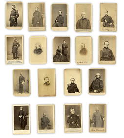
2 days LeftUniversity Archives18 pc. CDV Archive of Civil War Generals Incl. Many Brady & E. Anthony Examples$260(1 bid)
2 days LeftUniversity ArchivesIconic U.S. Grant Battlefield Albumen by Mathew Brady at City Point During Siege of Petersburg$400
4 days LeftSouth Florida Auction & Estate Sale Services IncABRAHAM LINCOLN Memorial Belt Buckle Approved by MRS. LINCOLN$22(2 bids)
Jul 07Worthington Galleries1st Edition Frank Leslie's The Soldier in Our Civil War: A Pictorial History of the Conflict$20(1 bid)
4 days LeftSouth Florida Auction & Estate Sale Services IncCivil War Abraham Lincoln Tin Type Photograph$8(2 bids)


![(ABRAHAM LINCOLN.) [Alexander Gardner], photographer. Carte-de-visite "inkwell portrait" of the (1 of 1)](https://p1.liveauctioneers.com/199/334052/180497937_1_x.jpg?height=282&quality=70&version=1718909401)


![[NUMISMATICS & PHILATELY]. Research library from the Estate of Carroll J. Delery III. (1 of 0)](https://p1.liveauctioneers.com/dist/images/placeholder.jpg?height=282&quality=70)