Sold2018L'Amerique Septentrionalis Map circa 1730L'Amerique Septentrionalis Map circa 1730: Aquatint map of North America, matted and framed. Dimensions are: image - 23 1/4" wide x 19" high, overall - 33" wide x 29 1/2" high. All measurements are apSee Sold Price
Sold2020c1730 Large Map of Netherlands ChatelainA large folding map of the Netherlands circa 1730 by Zacharias Chatelain, printed at Amsterdam. Very Good, nice bold impression with a couple of crease and small hole at fold point. Measures 19.75 x 1See Sold Price
Sold20231755 Robert De Vaugondy Map of North America Large1755 Robert De Vaugondy Map of America. Mid-Atlantic, New York, New Jersey, Pennsylvania Virginia, Maryland, New England, Carolina and Ohio. Partie De L'Amerique Septentrionale. Map in matte is aboutSee Sold Price
Sold2021VAN DER AA - Map of America, Leiden 1720VAN DER AA, Pieter (1659-1733). Nouvelle Carte de l'Amerique. Leiden: [circa 1720]. Copper-engraved map. Sheet size: 18 x 21 1/4 inches. (Expert restoration along the side margins). Decorative early 1See Sold Price
Sold2023Jaillot Map of South America with Exceptional ColorJAILLOT, Alexis Hubert (1632-1712). L'Amerique Meridionale. Engraved map with exceptional original color. Paris, c. 1691. 24 3/4" x 36 1/4" sheet. Large format map of South America, based upon earlierSee Sold Price
Sold2023Louisville & Nashville Railroad Posters [166764]14 large L & N Railroad poster calendars, each with a map of the routes, circa late 1940s-1960s. Overall size 22 x 28, each with crude plastic frames. Each poster at least two different colors printedSee Sold Price
Sold20201754 Bellin Map Gulf of Mexico West IndiesMap of Jacques Bellin circa 1754 entitled "Cartes Du Golphe Du Mexique Et Des Isles De L'Amerique", printed at Paris. Very Good, folds and light tatter, measures 16.5 x 13.5". Reserve: $70.00 ShippingSee Sold Price
Sold20221755 Map of North America by De VaugondyHistoric Maps 1755 French & Indian War Era Map of North America by De Vaugondy 1755-Dated French & Indian War Era, Large Hand-Colored Map titled, "PARTIE DE L'AMERIQUE SEPTENTRIONALE, QUI COMPREND LESee Sold Price
Sold2022MAP, Southern Alaska, BonneSouthern Alaska. Rigobert Bonne, Carte de la Riviere de Cook dans la Partie N.O. de l'Amerique, from Atlas Encyclopedique, 1787 (circa). Black & White. This handsome map shows Capt. Cook's discoveriesSee Sold Price
Sold2022[ANTIQUE MAP] VAUGONDY NOUVELLE FRANCE-CANADA 1755[ANTIQUE MAPS] de VAUGONDY, Robert. "CANADA PARTIE DE L'AMERIQUE SEPTENT QUI COMREND LA NOUVELLE FRANCE OU LE CANADA"Circa 1755. 61x47cm. Frame not included. Map will be removed from frame and securelSee Sold Price
Sold2023MAP, Western Hemisphere, Robert de VaugondyWestern Hemisphere - America. Didier Robert de Vaugondy, L'Amerique, from Nouvel Atlas Portatif, 1778 (circa). Hand Color. This handsome small map of the Americas is sparsely detailed, but interestingSee Sold Price
Sold2021Antique French Map of United States- Etats-Unis De L'Amerique Septentrionale Avec Les Isles Royale, De Terre Neuve, De St. Jean, L'Acadie &c.; Hand-colored; Ches Boudet Imprimeur du Roi; Paris; undated (circa 1785). One of the early maSee Sold Price
Sold2022Three Maps of North America, One World MapFour maps, including: Robert Wilkinson, The United States of America Confirmed By Treaty 1783, London, circa 1800-1812, engraving on wove paper; L'Amerique Septentrionale, "Terres vues par Tchirikov 1See Sold Price
Sold2018Very large map of South America, 1834Heading: Author: Brué, Adrien Hubert Title: Nouvelle carte de l'Amérique méridionale et des îles qui en dépendent... Place Published: Paris Publisher:Chez Chles. Piquet Date Published: 1834<See Sold Price
Sold202118TH CENTURY FRENCH MAP OF SOUTHEASTERN USRigobert Bonne (French, 1727-1794). "Carte De la Partie Sud Des Etats Unis De L'Amerique Septentrionale" -circa 1780, engraving. Provenance: From the Lifetime Collection of Billy S. Arant, Jr., ChattaSee Sold Price
Sold2022(CIVIL WAR.) Jean-Rodolphe Mayer. Nouvelle Carte des Etats-Unis de l'Amerique du Nord… 2de(CIVIL WAR.) Jean-Rodolphe Mayer. Nouvelle Carte des Etats-Unis de l'Amerique du Nord… 2de Edition. Large hand-colored lithographed map of the United States with a keyed reference table numberinSee Sold Price
Sold2023 [MAPS - COLONIAL NORTH AMERICA]. VAUGONDY, Gilles Robert de...[MAPS - COLONIAL NORTH AMERICA]. VAUGONDY, Gilles Robert de (1688-1766). Partie de l'Amerique Septentrionale qui Compred le Cours de l'Ohio… Paris, 1755. Large hand-colored engraved map (520 x 6See Sold Price
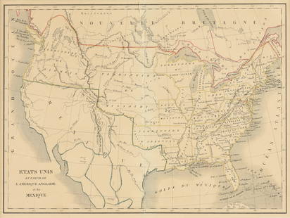
Sold2023EUSTACHE-HYACINTHE LANGLOIS (1777-1837) A MEXICAN TEXAS MAP, "Etats Unis et Partie de L'AméEUSTACHE-HYACINTHE LANGLOIS (1777-1837) A MEXICAN TEXAS MAP, "Etats Unis et Partie de L'Amérique Anglaise et du Mexique," PARIS, CIRCA 1830, lithograph on cream wove paper with hand color, probabSee Sold Price
Sold2021c1758 Hand Colored Map of South AmericaHand colored map of South America by Jacques Bellin published circa 1759 entitled "Carte De L'Amerique Meridionale Pour l'Histoire Generale des Voyages". On fine paper. Light corner creases, else FineSee Sold Price
Sold2019Hand-Colored Map of North America, 18th c."Carte du Continent de L'Amerique Nord." Circa late 18th c. On laid, sheet 14" x 11.5". Hand-colored, a couple of small marginal tears and light marginal chipping, the whole with some creases (as prevSee Sold Price
Sold20211627 Carte de l'Amerique Corrigee, et Augmentee, dessusBy: Bertius/TavernierDate: 1627 (circa)Dimensions: 20 x 15.25 inches (50.75 x 38.5 cm)According to Burden, "This rare map is one of a set of the four known continents that Melchior Tavernier had engraSee Sold Price
Sold2022(GEOGRAPHY.) Pierre d'Avity. Description General de l'Afrique [bound with:] Description Generale de(GEOGRAPHY.) Pierre d'Avity. Description General de l'Afrique [bound with:] Description Generale de L'Amerique. Two engraved title-pages in red and black, two large engraved decorative folding maps bySee Sold Price
Sold2017Dutch 'American Septentrionalis' map, circa 1647Johannes Janssonius, known as Jan Jansson (Dutch, 1588-1664), hand colored copper engraving titled 'America Septentrionalis,' executed in Amsterdam circa 1647, depicting a cartographic amalgamation ofSee Sold Price
Sold2017French Carte De L'amerique Map, 1750Map: Carte De L'amerique Publication Date: 1750 ca. Authors: ANONYMOUS Size: Octavo – 7.50 H x 5.50 W Inches Mid 18th Century French "L'Amerique." Shows the Gila River crossing the Colorato River. USee Sold Price
3 days LeftJasper52Carte du Golfe du Mexique et des Isles de l'Amerique' Caribbean BELLIN 1754 map$200
3 days LeftJasper52Antilles, Golfe du Mexique & Amérique Centrale. Caribbean. MALTE-BRUN c1871 map$35
2 days LeftFreeman's | Hindman[Maps & Atlases] Seutter, Matth(ias).: Novus Orbis sive America...$300(1 bid)
3 days LeftJasper52WEST INDIES Caribbean Windward Leeward Islands Barbados Pirates? MALLET 1683 map$240
5 days LeftSwann Auction Galleries(CALIFORNIA.) Edmond Guillemin-Tarayre. Mission Scientifique au Mexique et dans L'Amerique Centrale$900
3 days LeftJasper52L’Isle de St Domingue et… Porto-Rico. Hispaniola & Puerto Rico. BONNE 1788 map$40
3 days LeftJasper52Carte de l'Isle de la Martinique, Colonie Françoise…. Antilles. BONNE 1780 map$60
Jun 30Carrell AuctionsPOUL CADOVIUS for CADO Mid-Century Modern Modular Wall Shelving Unit$110(2 bids)
3 days LeftJasper52COLONIES FRANÇAISES AMÉRIQUE. Guyane Newfoundland Miquelon. LEVASSEUR c1854 map$40


![VAN DER AA - Map of America, Leiden 1720: VAN DER AA, Pieter (1659-1733). Nouvelle Carte de l'Amerique. Leiden: [circa 1720]. Copper-engraved map. Sheet size: 18 x 21 1/4 inches. (Expert restoration along the side margins). Decorative early 1](https://p1.liveauctioneers.com/7533/208644/106251140_1_x.jpg?height=310&quality=70&version=1624641782)

![Louisville & Nashville Railroad Posters [166764]: 14 large L & N Railroad poster calendars, each with a map of the routes, circa late 1940s-1960s. Overall size 22 x 28, each with crude plastic frames. Each poster at least two different colors printed](https://p1.liveauctioneers.com/2699/311018/166407876_1_x.jpg?height=310&quality=70&version=1701193734)


![[ANTIQUE MAP] VAUGONDY NOUVELLE FRANCE-CANADA 1755: [ANTIQUE MAPS] de VAUGONDY, Robert. "CANADA PARTIE DE L'AMERIQUE SEPTENT QUI COMREND LA NOUVELLE FRANCE OU LE CANADA"Circa 1755. 61x47cm. Frame not included. Map will be removed from frame and securel](https://p1.liveauctioneers.com/8321/253807/131946553_1_x.jpg?height=310&quality=70&version=1657219161)


![[MAPS - COLONIAL NORTH AMERICA]. VAUGONDY, Gilles Robert de...: [MAPS - COLONIAL NORTH AMERICA]. VAUGONDY, Gilles Robert de (1688-1766). Partie de l'Amerique Septentrionale qui Compred le Cours de l'Ohio… Paris, 1755. Large hand-colored engraved map (520 x 6](https://p1.liveauctioneers.com/928/301544/160920952_1_x.jpg?height=310&quality=70&version=1694462960)


![(GEOGRAPHY.) Pierre d'Avity. Description General de l'Afrique [bound with:] Description Generale de: (GEOGRAPHY.) Pierre d'Avity. Description General de l'Afrique [bound with:] Description Generale de L'Amerique. Two engraved title-pages in red and black, two large engraved decorative folding maps by](https://p1.liveauctioneers.com/199/251723/130782465_1_x.jpg?height=310&quality=70&version=1655133895)


![[Maps & Atlases] Seutter, Matth(ias).: Novus Orbis sive America... (1 of 2)](https://p1.liveauctioneers.com/65/332523/179335174_1_x.jpg?height=282&quality=70&version=1717709447)


