Sold2018L'Amerique Septentrionalis Map circa 1730L'Amerique Septentrionalis Map circa 1730: Aquatint map of North America, matted and framed. Dimensions are: image - 23 1/4" wide x 19" high, overall - 33" wide x 29 1/2" high. All measurements are apSee Sold Price
Sold2021VAN DER AA - Map of America, Leiden 1720VAN DER AA, Pieter (1659-1733). Nouvelle Carte de l'Amerique. Leiden: [circa 1720]. Copper-engraved map. Sheet size: 18 x 21 1/4 inches. (Expert restoration along the side margins). Decorative early 1See Sold Price
Sold20201754 Bellin Map Gulf of Mexico West IndiesMap of Jacques Bellin circa 1754 entitled "Cartes Du Golphe Du Mexique Et Des Isles De L'Amerique", printed at Paris. Very Good, folds and light tatter, measures 16.5 x 13.5". Reserve: $70.00 ShippingSee Sold Price
Sold2022MAP, Southern Alaska, BonneSouthern Alaska. Rigobert Bonne, Carte de la Riviere de Cook dans la Partie N.O. de l'Amerique, from Atlas Encyclopedique, 1787 (circa). Black & White. This handsome map shows Capt. Cook's discoveriesSee Sold Price
Sold2022[ANTIQUE MAP] VAUGONDY NOUVELLE FRANCE-CANADA 1755[ANTIQUE MAPS] de VAUGONDY, Robert. "CANADA PARTIE DE L'AMERIQUE SEPTENT QUI COMREND LA NOUVELLE FRANCE OU LE CANADA"Circa 1755. 61x47cm. Frame not included. Map will be removed from frame and securelSee Sold Price
Sold2023MAP, Western Hemisphere, Robert de VaugondyWestern Hemisphere - America. Didier Robert de Vaugondy, L'Amerique, from Nouvel Atlas Portatif, 1778 (circa). Hand Color. This handsome small map of the Americas is sparsely detailed, but interestingSee Sold Price
Sold2021Antique French Map of United States- Etats-Unis De L'Amerique Septentrionale Avec Les Isles Royale, De Terre Neuve, De St. Jean, L'Acadie &c.; Hand-colored; Ches Boudet Imprimeur du Roi; Paris; undated (circa 1785). One of the early maSee Sold Price
Sold2022Three Maps of North America, One World MapFour maps, including: Robert Wilkinson, The United States of America Confirmed By Treaty 1783, London, circa 1800-1812, engraving on wove paper; L'Amerique Septentrionale, "Terres vues par Tchirikov 1See Sold Price
Sold202118TH CENTURY FRENCH MAP OF SOUTHEASTERN USRigobert Bonne (French, 1727-1794). "Carte De la Partie Sud Des Etats Unis De L'Amerique Septentrionale" -circa 1780, engraving. Provenance: From the Lifetime Collection of Billy S. Arant, Jr., ChattaSee Sold Price
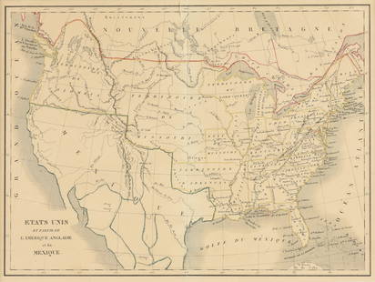
Sold2023EUSTACHE-HYACINTHE LANGLOIS (1777-1837) A MEXICAN TEXAS MAP, "Etats Unis et Partie de L'AméEUSTACHE-HYACINTHE LANGLOIS (1777-1837) A MEXICAN TEXAS MAP, "Etats Unis et Partie de L'Amérique Anglaise et du Mexique," PARIS, CIRCA 1830, lithograph on cream wove paper with hand color, probabSee Sold Price
Sold2021c1758 Hand Colored Map of South AmericaHand colored map of South America by Jacques Bellin published circa 1759 entitled "Carte De L'Amerique Meridionale Pour l'Histoire Generale des Voyages". On fine paper. Light corner creases, else FineSee Sold Price
Sold2019Hand-Colored Map of North America, 18th c."Carte du Continent de L'Amerique Nord." Circa late 18th c. On laid, sheet 14" x 11.5". Hand-colored, a couple of small marginal tears and light marginal chipping, the whole with some creases (as prevSee Sold Price
Sold20211627 Carte de l'Amerique Corrigee, et Augmentee, dessusBy: Bertius/TavernierDate: 1627 (circa)Dimensions: 20 x 15.25 inches (50.75 x 38.5 cm)According to Burden, "This rare map is one of a set of the four known continents that Melchior Tavernier had engraSee Sold Price
Sold2017Dutch 'American Septentrionalis' map, circa 1647Johannes Janssonius, known as Jan Jansson (Dutch, 1588-1664), hand colored copper engraving titled 'America Septentrionalis,' executed in Amsterdam circa 1647, depicting a cartographic amalgamation ofSee Sold Price
Sold2017French Carte De L'amerique Map, 1750Map: Carte De L'amerique Publication Date: 1750 ca. Authors: ANONYMOUS Size: Octavo – 7.50 H x 5.50 W Inches Mid 18th Century French "L'Amerique." Shows the Gila River crossing the Colorato River. USee Sold Price
Sold2022Colored engraving L´AMERIQUE MERIDIONALE. Map of AMERICA, from N. Spain to Tierra del Fuego,Colored engraving L´AMERIQUE MERIDIONALE. Map of AMERICA, from N. Spain to Tierra del Fuego, bordered with 12 cartouches without image. Copper engraving by Baeck, according to Jaillot, for his workSee Sold Price
Sold2020L’Amerique Septentrionale MapOn laid paper North America and Arctic frame 31 x 28See Sold Price
Sold2019Carte du Golfe du Mexique et des Isles de l'Amerique'TITLE/CONTENT OF MAP: 'Carte du Golfe du Mexique et des Isles de l'Amerique [Map of the Gulf of Mexico and the Caribbean islands]' DATE PRINTED: 1754 IMAGE SIZE: Approx 28.5 x 39.0cm, 11.25 x 15.5 incSee Sold Price
Sold2023Carte du Golfe du Mexique et des Isles de l'Amerique' Caribbean BELLIN 1754 mapTitle: Carte du Golfe du Mexique et des Isles de l'Amerique' Caribbean BELLIN 1754 map Description: Carte du Golfe du Mexique et des Isles de l'Amerique [Map of the Gulf of Mexico and the Caribbean isSee Sold Price
Sold2019Gilles Robert de Vaugondy (1688-1766), "Partie deGilles Robert de Vaugondy (1688-1766), "Partie de L'Amerique Septentrionalis qui comprend e lours de L'Ohio, la NIie Anglaterre, la NIie York, le Ne, Jersey, La Pennsylvania, Le Maryland Virginie, LaSee Sold Price
Sold2020A LOUIS XIV MAP, "L'Amerique Septentrionale," HUBERTA LOUIS XIV MAP, "L'Amerique Septentrionale," HUBERT JAILLOT, PARIS, 1696, hand colored engraving on paper, "Divisée en ses principals parties, ou sont distingués les uns des autres Les Estats suivaSee Sold Price
Sold2020L'amerique Septentrionale 1706 Map North AmericaL'amerique Septentrionale 1706 Map Of North America (french). 24 X 20 Inches, Framed.See Sold Price
Sold20221806-Dated LAmerique Western Hemisphere MapHistoric Maps 1806 Western Hemisphere Map "L'Amerique divifee Pars Grands Etats Janvier C.F. Delamarche, Robert deVaugondy" 1806-Dated Hand-Colored Engraved Copper Plate Map of the Western HemisphereSee Sold Price
Sold2017Janvier Map L'AmeriqueL'Amerique divisée en ses principaux Etats...Janvier Sr. (18th. century). Engraved map with original hand color in full. Paris, 1760. 22 x 28 1/2 inches sheet.See Sold Price
Featured6 days LeftJasper52Carte du Golfe du Mexique et des Isles de l'Amerique' Caribbean BELLIN 1754 map$200
6 days LeftJasper52Antilles, Golfe du Mexique & Amérique Centrale. Caribbean. MALTE-BRUN c1871 map$35
6 days LeftJasper52WEST INDIES Caribbean Windward Leeward Islands Barbados Pirates? MALLET 1683 map$220
May 14Fleischer's Auctions1755 Map Partie de l'Amerique Septentrionale, qui comprend Le Cours de L'Ohio...$200(3 bids)
May 14Akiba Galleries(2 Pc) Allain Manesson Mallet Description De L'Univers 2 Vol. German Translation$200(1 bid)
6 days LeftJasper52WEST INDIES. Sugarcane plantation & press/mill. Slaves. ' Sucrerie'. MALLET 1683$75
2 days LeftRapid Estate Liquidators and Auction GallerySigned L'Amerique des Francais French Paperback$25
May 16Heritage Auctions74125: A Henricus Boelen Coin Silver Porringer, New Yor$900(3 bids)
May 10Crescent City Auction GalleryAfter Pieter Cramer (Dutch, 1721-1776) "Papillons Exotiques des Trois Parties du Monde l'Asie,$400
May 16Potter & Potter AuctionsLa Reponse de L’Amerique aux Boches. Paris: Louchet Publici...$400


![VAN DER AA - Map of America, Leiden 1720: VAN DER AA, Pieter (1659-1733). Nouvelle Carte de l'Amerique. Leiden: [circa 1720]. Copper-engraved map. Sheet size: 18 x 21 1/4 inches. (Expert restoration along the side margins). Decorative early 1](https://p1.liveauctioneers.com/7533/208644/106251140_1_x.jpg?height=310&quality=70&version=1624641782)


![[ANTIQUE MAP] VAUGONDY NOUVELLE FRANCE-CANADA 1755: [ANTIQUE MAPS] de VAUGONDY, Robert. "CANADA PARTIE DE L'AMERIQUE SEPTENT QUI COMREND LA NOUVELLE FRANCE OU LE CANADA"Circa 1755. 61x47cm. Frame not included. Map will be removed from frame and securel](https://p1.liveauctioneers.com/8321/253807/131946553_1_x.jpg?height=310&quality=70&version=1657219161)


![Carte du Golfe du Mexique et des Isles de l'Amerique': TITLE/CONTENT OF MAP: 'Carte du Golfe du Mexique et des Isles de l'Amerique [Map of the Gulf of Mexico and the Caribbean islands]' DATE PRINTED: 1754 IMAGE SIZE: Approx 28.5 x 39.0cm, 11.25 x 15.5 inc](https://p1.liveauctioneers.com/5584/144578/73088245_1_x.jpg?height=310&quality=70&version=1561513819)


