Sold20221759 Voyages in CARIBBEAN Jamaica Barbados MAPS Pirates America Slave Trade1759 Voyages in CARIBBEAN Jamaica Barbados MAPS Pirates America Slave Trade The General History of Voyages by abbe Prevost is one of the largest and most impressive collections of stories of expeditioSee Sold Price
Sold2020Speed Map of Jamaica and Barbados 1676John Speed (ca. 1552-1629), "A Map of Jamaica, Barbados," London: Thomas Bassett, 1676. This map of Jamaica and Barbados features lovely topographical details, and elaborate strapwork cartouches, oneSee Sold Price
Sold2021West Indies.- Speed (John) A Map of Jamaica [on sheetWest Indies.- Speed (John) A Map of Jamaica [on sheet with] Barbados, 2 maps on 1 sheet, each with decorative title cartouches, compass roses, ships and sea monsters, engravings with hand-colouring, 4See Sold Price
Sold2017Homann: British West Indies/Atlantic Islands Map, 1740Map: Dominia Anglorum. British West Indies/Atlantic islands of St Christopher (St Kitts), Antigua, Bermuda, Jamaica & Barbados Date Printed: c1740 Image Size: Approx 52.5 x 59.5cm, 20.5 x 23.25 inchesSee Sold Price
Sold2018Homann Heirs: British Caribbean and Atlantic IslandsDominia Anglorum in praecipuis Insulis Americae On one sheet, five highly detailed maps of British possessions in the Caribbean and Atlantic: St. Kitts, Antigua, Bermuda, Barbados, and Jamaica. St. KiSee Sold Price
Sold2018Senex: Antique Map Jamaica & British West Indies, 1721Title/Content of Map: A new map of the English Empire in the Ocean of America or West Indies Cartographer: J. Senex Place & Date: London / 1721 Size: 23 3/4" x 20" Condition: full wash color; repairedSee Sold Price
Sold2021Tallis, John (Pub) 1852 Map. JamaicaSteel Engraved Map with Original Outline Hand Color Published 1852-56 by John Tallis, London for "The Universal Pronouncing Dictionary" by Thomas Wright. Drawn & Engraved by John Rapkin. Centre fold aSee Sold Price
Sold2017Jamaica British West Indies Antique Map, 1835Map: Jamaica British West Indies Antique Map Size: 15.5"W × 0.1"D × 13.0"H Year: 1835 Please note that this lot has a confidential reserve. When you leave a bid in advance of the auction, submit youSee Sold Price
Sold2018Cram: Antique Map of the West Indies, 1892West Indies. Cram's large, highly detailed map of the West Indies from his Superior Atlas of the World features shipping routes and undersea cables. On the verso are two separate maps: "Jamaica, HaitiSee Sold Price
Sold2018H. Moll: Antique Map of Jamaica, 1746Title/Content of Map: Jamaica by H. Moll Date Printed: 1746 Cartographer: H. Moll Material/Medium: Paper Size: 14 1/2" x 9 1/2" Published in London. Copperplate engraved. Please note that this lot hasSee Sold Price
Sold2018Bellin: Antique Map of Jamaica, 1740-70Title/Content of Map: Jamaica by Bellin Date Printed: 1740-70's Cartographer: J.N. Bellin & J.F. La Harpe Material/Medium: Paper Size: 14 1/2" x 9 3/4" Copperplate engraved. From the 'Abrege de L'HistSee Sold Price
Sold2020British commonwealth stamp collection on 10 loose albumBritish commonwealth stamp collection on 10 loose album pages. Includes Barbados, Jamaica, Trinidad and Tobago and more. Good Condition. All autographs are genuine hand signed and come with a CertificSee Sold Price
Sold2020British commonwealth stamp collection on 10 loose albumBritish commonwealth stamp collection on 10 loose album pages. Includes Barbados, Jamaica, Trinidad and Tobago and more. Good Condition. All autographs are genuine hand signed and come with a CertificSee Sold Price
Sold2016Map of Barbados, 1716Original copper engraving by Herman Moll published in Atlas Geographicus, London, 1716. Dimensions: 13" x 16" Shipping Domestic: Shipping rates are determined by destination. International: Foreign shSee Sold Price
Sold20201758 Map of JamaicaAuthor: Bellin Title: 1758 Map of Jamaica Medium: Ink on paper Dimensions: 13.5" X 9" Map of Jamaica dated 1758. Engraved by Samuel Bellin engineer to the French Navy. Possible military map. Hand coloSee Sold Price
Sold2023Seutter Antique Hand Coloured Map of JamaicaMatthaeus Seutter (1678-1756) Antique Hand Coloured Map of Jamaica Titled Nova Designatio Insulae Jamaicae. Map measures 20 inches H x 23 within matting, frame measures 28 x 31 inches.See Sold Price
Sold2017Depot de la Marine: Antique Map of Jamaica, 1786Map: Carte de l'Ile de la Jamaique Cartographer: Dépôt de la Marine Place & Date: Paris / 1786/1799 Size: 34" x 23" Condition: b&w; ink spots along left margin This superbly engraved, large-scale D�See Sold Price
Sold2017Buchon: Antique Geographical Map of Jamaica, 1825Map: Carte Geographique, Statistique Et Historique De La Jamaique Publication Date: 1825 Authors: Buchon, Buchon Publisher: Buchon Size: Folio – 11.30 H x 11.80 W Inches Map showing island divided iSee Sold Price
Sold20231780 Voyages in CARIBBEAN Thomas Warner Antilles Jamaica Barbados Dominican1780 Voyages in CARIBBEAN Thomas Warner Antilles Jamaica Barbados Dominican The best book of its kind! A rare book La Harpes General History of Voyages! This extensive work was begun by La Harpe, and,See Sold Price
Sold2017Bellin: Map of Jamaica, 1756Map: 1756 Bellin Map of Jamaica -- Carte de l'Isle de la Jamaique Cartographer: J Bellin Year / Place: 1758, Paris Map Dimensions: 8.1 x 12.6 in. A nice, and strongly engraved map of Jamaica. DividedSee Sold Price
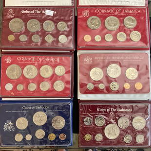
Sold2023Group of 6 Uncirculated Coin Sets Bahamas, Jamaica, Barbados, Trinidad and Tobago 1975-1977Group of 6 Uncirculated Coin Sets Bahamas, Jamaica, Barbados, Trinidad and Tobago 1975-1977, All in display folders, 1975 Uncirculated Coinage of Jamaica, 1975 Uncirculated Coins of Barbados, 197See Sold Price
Sold2021Map of Jamaica, 1839Map of Jamaica, 1839A nicely colored map of the island nation of Jamaica, “compiled chiefly fro manuscripts in the colonial office and admiralty by John Arrowsmith”. This map shows high deSee Sold Price
Sold2017Arrowsmith: Antique Map of Jamaica, 1842Title/Content of Map: Map of Jamaica Publication Date: 1842-04-22 Authors: J. ARROWSMITH, ARROWSMITH, JOHN Publisher: J. ARROWSMITH Size: Folio – 12.80 H x 23.75 W Inches "compiled chiefly fromSee Sold Price
Sold2018Bonne: Antique Map of Jamaica, 1780TITLE/CONTENT OF MAP: 'Carte de l'Isle de la Jamaique' A map of Jamaica DATE PRINTED: 1780 IMAGE SIZE: Approx 23.0 x 34.0cm, 9 x 13.25 inches (Large); Please note that this is a folding map. TYPE: AntSee Sold Price
Jun 07Freeman's | HindmanHUGHES, Griffith. The Natural History of Barbados. 1750. FIRST EDITION.$1,000
1 day LeftFleischer's Auctions1755 Map Partie de l'Amerique Septentrionale, qui comprend Le Cours de L'Ohio...$200(3 bids)
6 days LeftBlackstone Valley Auctions & Estates LLCRevolutionary Era War Map of the Attack on Ft. Moultrie.$225(3 bids)
2 days LeftDavid Skinner Antiques19th Century Barbados Regency Mahogany and Cedrela Cupping Table$900
2 days LeftUniversity ArchivesFeb. 1777 Issue of The Gentleman's Magazine with Superb Map of Philadelphia$140(1 bid)
JG AutographsBuckminster Fuller - Architect, Inventor, Futurist - Autographed Spaceship Earth Sky-Ocean Map Model$80(8 bids)
Jun 07Freeman's | Hindman[MAP]. TODESCHI, Pietro. [Nova et Acurata Totius Americae Tabula auct. G.I. Blaeu] America quarta$5,000
May 20Kensington Estate AuctionGordon Smith Silver Print Photograph, Constance Brown, Jamaica 1989$150
3 days LeftPotter & Potter AuctionsArmour’s Food Source Map / The Greatness of the United Stat...$200
3 days LeftPotter & Potter AuctionsPictorial Map of Hollywood and Vicinity / Hollywood Film Ca...$125(1 bid)


![West Indies.- Speed (John) A Map of Jamaica [on sheet: West Indies.- Speed (John) A Map of Jamaica [on sheet with] Barbados, 2 maps on 1 sheet, each with decorative title cartouches, compass roses, ships and sea monsters, engravings with hand-colouring, 4](https://p1.liveauctioneers.com/5458/196505/99195241_1_x.jpg?height=310&quality=70&version=1614947560)


![[MAP]. TODESCHI, Pietro. [Nova et Acurata Totius Americae Tabula auct. G.I. Blaeu] America quarta (1 of 1)](https://p1.liveauctioneers.com/197/329395/177650542_1_x.jpg?height=282&quality=70&version=1715364962)


