Sold2021Findlay, Alex C1835 Antique Map. Hindoostan IndiaSteel Engraved Map Published C1835 by Thomas Kelly, London for "A New and Universal English Dictionary" by the Rev. James Barclay. Maps Drawn & Engraved by Alexander Findlay. Paper Size: 10.5 x 8 inchSee Sold Price
Sold2022Findlay, Alex C1835 Antique Map. Hindoostan IndiaSteel Engraved Map Published C1835 by Thomas Kelly, London for "A New and Universal English Dictionary" by the Rev. James Barclay. Maps Drawn & Engraved by Alexander Findlay. Paper Size: 10.5 x 8 inchSee Sold Price
Sold2018Wyld, James C1850's Map of Turkey & Ottoman Empire"European Dominions of the Ottomans or Turkey in Europe" Lithograph Map Published C1850's by James Wyld, London. Originally Copper Engraved, this a Lithograph Map by the same Publishers. Outline handSee Sold Price
Sold2019India.- Wyld (James) Map of the Countries betweenIndia.- Wyld (James) Map of the Countries between England and India Designed to shew the Over-Land and Sea Routes to the East..., map of Europe and Asia between Britain and India, with the MediterraneSee Sold Price
Sold2018Wyld, James C1840 Group of 4 Hand Coloured MapsIncl Spain/Portugal, Syria, Asia and Turkey in Asia. Hand Coloured Steel Engraved Map Published C1840, London for "Atlas of Modern Geography" by James Wyld. Centre fold as published. Paper Size: 11 xSee Sold Price
Sold2021Barclay, James C1835 Hand Col Map. Africa ContinentHand Colored Copper Engraved Map Published C1835, London for "A Complete and Universal English Dictionary" by the Rev. James Barclay et al. Folds as issued. Paper Size: 11 x 8.5 inch (28 x 22cm) GoodSee Sold Price
Sold2020Barclay, James C1835 Hand Col Map. West IndiesHand Colored Copper Engraved Map Published C1835, London for "A Complete and Universal English Dictionary" by the Rev. James Barclay et al. Folds as issued. Paper Size: 11 x 8.5 inch (28 x 22cm) GoodSee Sold Price
Sold2021Barclay, James C1835 Hand Col Map. IrelandHand Colored Copper Engraved Map Published C1835, London for "A Complete and Universal English Dictionary" by the Rev. James Barclay et al. Paper Size: 11 x 8.5 inch (28 x 22cm) Good ConditionSee Sold Price
Sold2021Barclay, James C1835 Hand Colored Map of EuropeHand Colored Copper Engraved Maps Published C1835, London for "A Complete and Universal English Dictionary" by the Rev. James Barclay et al. Engraved by Bingley. Paper Size: 11 x 8.5 inch (28 x 22cm)See Sold Price
Sold2020Barclay, James C1835 Pair of Hand Col Maps. NetherlandsHand Colored Copper Engraved Map Published C1835, London for "A Complete and Universal English Dictionary" by the Rev. James Barclay et al. Folds as issued. Paper Size: 11 x 8.5 inch (28 x 22cm) GoodSee Sold Price
Sold2022Barclay, James C1835 Print. View of Naples, Italy.Steel Engraved Map Published C1835 by Thomas Kelly, London for "A New and Universal English Dictionary" by the Rev. James Barclay. Paper Size: 10.5 x 8 inch (27 x 21cm) Very light water stain in leftSee Sold Price
Sold2021Barclay, James C1835 Hand Colored Map of EuropeHand Colored Copper Engraved Maps Published C1835, London for "A Complete and Universal English Dictionary" by the Rev. James Barclay et al. Engraved by Bingley. Paper Size: 11 x 8.5 inch (28 x 22cm)See Sold Price
Sold2021Barclay, James C1835 Print. View of Quebec, CanadaSteel Engraved Map Published C1835 by Thomas Kelly, London for "A New and Universal English Dictionary" by the Rev. James Barclay. Paper Size: 10.5 x 8 inch (27 x 21cm) Very minor margin toning, otherSee Sold Price
Sold2020Barclay, James C1835 Hand Col Map. Russia in EuropeOutline Hand Colored Copper Engraved Map Published C1835, London for "A Complete and Universal English Dictionary" by the Rev. James Barclay et al. Folds as issued. Paper Size: 11 x 8.5 inch (28 x 22cSee Sold Price
Sold2021Barclay, James C1835 Hand Col Map. Asia ContinentHand Colored Copper Engraved Map Published C1835, London for "A Complete and Universal English Dictionary" by the Rev. James Barclay et al. Folds as issued. Paper Size: 11 x 8.5 inch (28 x 22cm) GoodSee Sold Price
Sold2021Barclay, James C1835 Lot of 4 Hand Col Europe MapsGermany, Holland/Belgium, France and Spain/Portugal. Hand Colored Steel Engraved Maps Published C1835, London for "A Complete and Universal English Dictionary" by the Rev. James Barclay et al. EngraveSee Sold Price
Sold20201860 Map of ItalyAuthor: Stockley Title: 1860 Map of Italy Medium: Ink on Paper Dimensions: 9"X10.5" Description: Map of Italy and Switzerland dated 1860. Engraved by James Stockley. Published by James Wyld engraver tSee Sold Price
Sold20201860 Map of the United StatesAuthor: Stockley Title: 1860 Map of the United States Medium: Ink on Paper Dimensions: 10.5"X9" Map of the United States dated 1860. Engraved by James Stockley. Published by James Wyld engraver to QueSee Sold Price
Sold20201860 Map of ScotlandAuthor: Stockley Title: 1860 Map of Scotland Medium: Ink on Paper Dimensions: 9"X10.5" Description: Map of Scotland dated 1860. Engraved by James Stockley. Published by James Wyld engraver to Queen ViSee Sold Price
Sold20201860 Map of IrelandAuthor: Stockley Title: 1860 Map of Ireland Medium: Ink on Paper Dimensions: 9"X10.5" Description: Map of Ireland dated 1860. Engraved by James Stockley. Published by James Wyld engraver to Queen VictSee Sold Price
Sold20201860 Map of EgyptAuthor: Stockley Title: 1860 Map of Egypt Medium: Ink on Paper Dimensions: 9"X10.5" Description: Map of Egypt dated 1860. Engraved by James Stockley. Published by James Wyld engraver to Queen VictoriaSee Sold Price
Sold20211860 Russia and Poland MapAuthor: Stockley Title: 1860 Russia and Poland Map Medium: Ink on Paper Dimenions: 9"X10.5" Description: Map of Russia and Poland dated 1860. Engraved by James Stockley. Published by James Wyld engravSee Sold Price
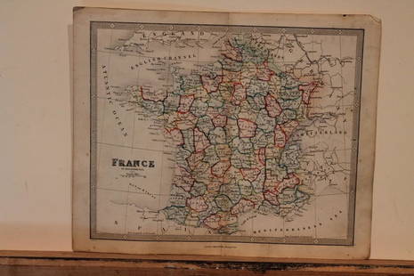
Sold20211860 Map of FranceAuthor: Stockley Title: 1860 Map of France Medium: Ink on Paper Dimensions: 10.5"X9" Map of France dated 1860. Engraved by James Stockley. Published by James Wyld engraver to Queen Victoria in CharingSee Sold Price
Sold2021A Map of East India Archipelago Chart No. 5, 1871A Map of East India Archipelago Chart No. 5, 1871, Western route to China. Showing Hainan Island, Peninsula of Lein-Chew Mainland China. Eight insets including Hong Kong. Published: James Imray & Son,See Sold Price
Jun 13Swann Auction Galleries(CASE MAPS.) Group of 7 nineteenth-and-early-twentieth-century engraved or lithographed maps of$1,100
Jun 12Jasper52Part of the Western Coast of Africa…' by James Wyld. Sierra Leone 1840 old map$280
Jun 13Swann Auction Galleries(CASE MAPS.) Group of 7 nineteenth-and-early-twentieth-century engraved or lithographed maps of$500


![[India] Rennell, James, Major (1 of 2)](https://p1.liveauctioneers.com/94/330664/178342480_1_x.jpg?height=282&quality=70&version=1716466933)


