Sold2022Map of the Cordilleran Region Showing the Distribution of Woods and ForestsPublication Date: 1898 Title: Map of the Cordilleran Region Showing the Distribution of Woods and Forests Cartographer: GANNETT, HENRY Publisher: U.S. GEOLOGICAL SURVEY Height: 36.25 Width: 29.5 NinetSee Sold Price
Sold20181850 Petermann Map of the Distribution of ActiveTitle/Content of Map: 1850 Petermann Map of the Distribution of Active Volcanoes and Eartquake Prone Regions Globally -- Map of the World Showing the Distribution of Active Volcanoes and Regions VisitSee Sold Price
Sold2019Scarce 1850 plants distributionScarce 1850 map or chart by Joseph Meyer depicting plant geography. Shows the distribution of vegetation throughout the world. Features five illustrations showing the vegetation in various regions, inSee Sold Price
Sold2024Map Showing Distribution of Pinus Palustris (Longleaf Pine) & Pinus Cubensis (Cuban Pine) | PinusPublication Date: 1891 Title: Map Showing Distribution of Pinus Palustris (Longleaf Pine) & Pinus Cubensis (Cuban Pine) | Pinus Echinata (Shortleaf Pine) | Pinus Taeda (Loblolly Pine) Cartographer: SCSee Sold Price
Sold2021Map Showing the Distribution of the Tribes of AlaskaPublication Date: 1875 Title: Map Showing the Distribution of the Tribes of Alaska and Adjoining Territory Cartographer: DALL, W.H. | C.W. RAYMOND | DAVIDSON Publisher: U.S. COAST & GEODETIC SURVEY OFSee Sold Price
Sold2018Map Showing the Distribution of the Indian Tribes, 1876Title/Content of Map: ... Map Showing the Distribution of the Indian Tribes of Washington Territory Date Printed: 1876 Cartographer: DALL, W. H. Size: 19.75X15.5 Elegant topographical and ethnologic mSee Sold Price
Sold2017Map Showing The Distribution Of The Genus JuglansMap Showing The Distribution Of The Genus Juglans [the Walnuts] In North America Exclusive Of Mexico. Dept. Of The Interior. 10th Census, Gannett, Henry/harry King, 1883, Folio – 17.40 H X 27.40 W ISee Sold Price
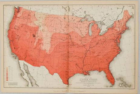
Sold2022Map Showing the Distribution of Wealth.Publication Date:1874 Title:Map Showing the Distribution of Wealth. Cartographer:WALKER, FRANCIS A. Publisher:BUREAU OF THE CENSUS Height:19.75 Width:14.75 Compiled from the tables of true valuation,See Sold Price
Sold2022PAIGE, Paul. A Map of Cape Cod. East Brewster, MA, ca. 1940...PAIGE, Paul. A Map of Cape Cod. East Brewster, MA, ca. 1940s. Pictorial map showing towns, forests, bridges, lighthouses, and landmarks, marking vacation and tourist attractions, including a key to goSee Sold Price
Sold20191850 Petermann Map of the Distribution of Birds andTitle/Content of Map: 1850 Petermann Map of the Distribution of Birds and Reptiles Globally -- Zoological Map Showing the Distribution of Birds and Reptiles (Aves et Reptilia) over the Globe Date: 185See Sold Price
Sold20191850 Petermann Map of the Distribution of MammalsTitle/Content of Map: 1850 Petermann Map of the Distribution of Mammals Globally -- Zoological Map Showing the Distribution of the Principal Mammiferous Animals (Class Mammalia) over the Globe Date: 1See Sold Price
Sold2022WORLD WAR 2. Maginot & Siegfried lines defences. Pre-invasion. Belgium 1940 mapTITLE/CONTENT OF MAP: 'Western Front showing forests and main defences: Section 2' DATE PRINTED: March 1940 IMAGE SIZE: Approx 26.5 x 42.0cm, 10.25 x 16.5 inches (Large) TYPE: Vintage colour map; ScalSee Sold Price
Sold2022China.- Speed (John) The Kingdome of China newly augmented, 1626.China.- Speed (John) The Kingdome of China newly augmented, the only carte-a-figures map made of the region, showing China, Korea and Japan, with 8 costumed figures along the left and right borders, aSee Sold Price
Sold2021Map of the Polar Regions - Arctic DiscoveriesMap of the Polar Regions Showing Recent Discoveries With Mercator Map of the Eastern Hemisphere on verso Cartographer: George Franklin Cram Dated: Circa 1900See Sold Price
Sold2019Bryce, James 1881 Lot 3 Maps World. Temperature, BirdsIncl 2 Temperature Maps and one showing the distribution of Birds and Fish. Lithograph Maps Published 1881, London for ""The International Atlas and Geography..." by James Bryce. Maps by Edward WellerSee Sold Price
Sold2017Guillaume Blaeu: Map of Russia, Estonia to Moscow, 1660Russiae Vulgo Moscovia dictae Pars Occidentalis. By: Guillaume Blaeu Date: c. 1660 Dimensions: 19.25 x 15 in. (49 x 38.5 cm) This is an attractive early 17th century map showing the region of Russia fSee Sold Price
Sold20211660 Russiae Vulgo Moscovia dictae Pars OccidentalisBy: Guillaume BlaeuDate: 1660 (circa)Dimensions: 19.25 x 15 inches (49 x 38.5 cm)This is an attractive early 17th century map showing the region of Russia from Estonia to Moscow. Topographical featureSee Sold Price
Sold2019Rare 1st ed. German world distribution, 1846World map in partial color showing the distribution of Germans throughout the world. Inset maps showing the specific spread of Germans in North America and South America. Inset shows Germans in NorthSee Sold Price
Sold20181850 Petermann World Map of the Human RaceTitle/Content of Map: 1850 Petermann World Map of the Human Race -- Ethnographical Map of the World Showing the Distribution of the Human Race in the Middle of the 19th Century Date Printed: 1850, LonSee Sold Price
Sold2019Isothermal Curves of N. Hemisphere, 1850Scarce map showing northern regions of the globe, along with the isothermal curves in that hemisphere. By Joseph Meyer from Meyer’s Zeitungs-Atlas of 1850. General toning with some scattered foxing.See Sold Price
Sold2021U. S. TERRITORY STILL UNDER INSURRECTIONARY CONTROLCivil War Dated Wood Engraved Map MAP SHOWING THE EXTENT OF UNITED STATES TERRITORY STILL UNDER INSURRECTIONARY CONTROL, Harper's Weekly, June 28, 1862 (Civil War, Confederate States, Rebels, SuccessiSee Sold Price
Sold2022Map Showing Location and Extent of the Forest Reserves and National Parks in Western United StatesPublication Date: 1900 Title: Map Showing Location and Extent of the Forest Reserves and National Parks in Western United States 1899 Cartographer: U.S. GEOLOGICAL SURVEY Publisher: U.S. GEOLOGICAL SUSee Sold Price
Sold2020Reconnoissance Map of the United States Showing theTitle: Reconnoissance Map of the United States Showing the Distribution of The Geologic System Cartographer: MC GEE, W. J. Date: 1893 Publisher: U.S. GEOLOGICAL SURVEY Size: 17.5Height - 28.25Width AdSee Sold Price
Sold20211880 Gannett Climate Map of the US with IsothermalTitle: 1880 Gannett Climate Map of the US with Isothermal Minimum Temperature Lines -- Map of the United states Showing the Distribution of Lines of Minimum Temperature… Cartographer: H Gannett / DeSee Sold Price
Jun 12Dan Morphy AuctionsPLATE CXIII. MAP OF INDIAN TERRITORY SHOWING DISTRIBUTION OF WOODLAND” FROM THE TWENTY-FIRST$100
5 days LeftJasper521788 Bowen Map of Ottoman Empire and Mediterranean Region -- A Correct Map of the Ottoman Empire,$140
Featured6 days LeftJasper52India North Western Frontier Kashmir Pamir region Afghanistan. STANFORD 1896 map$280
May 29Cedarburg Auction & Appraisals LLCSet of Four Maps Showing All of Spain and Portugal$125(2 bids)
7 days LeftForum AuctionsLondon.- River Thames.- Tombleson (William) Tombleson’s Panoramic Map of the River Thames and£260
30 mins LeftPotter & Potter AuctionsLISTER, James Wren (1897 – 1952). Avalon Town / Santa Catal...$100(1 bid)
30 mins LeftPotter & Potter AuctionsMcCARTY, Lea (1905 – 1960). Sonoma County / Its Highlights ...$100(1 bid)
30 mins LeftPotter & Potter AuctionsPan American Airways World System Map. 1956. Art by John Br...$200
30 mins LeftPotter & Potter AuctionsLANGENECKERT. It’s A Dog’s World. 1968. St. Louis: Ralston ...$100
Jun 07Freeman's | HindmanHOMANN, Johann Baptist. Amplissimae Regionis Mississipi Seu Provinciae Ludovicianae. Nuremburg, [ca$400
Jun 07Freeman's | HindmanMURCHISON, Roderick Impey, Sir. The Silurian System. 1839. COMPLETE WITH VERY RARE HAND-COLORED$1,500
3 days LeftRich Penn AuctionsPetroliana Phillips 66 Dist-O-Map, aluminum litho w/rotating inner wheel showing distances, VG$50
30 mins LeftPotter & Potter AuctionsLINDGREN, Hjalmer “Jolly” (1895–1952). A Hysterical Map of ...$150(1 bid)
30 mins LeftPotter & Potter AuctionsBODLEY, Helen (1906 – 1997). A Map of Concord / The Old Mus...$400


![Map Showing The Distribution Of The Genus Juglans: Map Showing The Distribution Of The Genus Juglans [the Walnuts] In North America Exclusive Of Mexico. Dept. Of The Interior. 10th Census, Gannett, Henry/harry King, 1883, Folio – 17.40 H X 27.40 W I](https://p1.liveauctioneers.com/5584/101555/51863510_1_x.jpg?height=310&quality=70&version=1489788854)


![[MAP]. SPEED, John. A New Mappe of the Romane Empire. 1676. (1 of 2)](https://p1.liveauctioneers.com/197/329395/177650541_1_x.jpg?height=282&quality=70&version=1715364962)


![[MAP]. ORTELIUS, Abraham. Romani Imperii Imago. 1592. (1 of 2)](https://p1.liveauctioneers.com/197/329395/177650537_1_x.jpg?height=282&quality=70&version=1715364962)
