Sold202218th C. WAYNE COUNTY PA DRAWN PROPERTY DRAFT MAPLAND SURVEYED DECEMBER OF 1784, SIGNED BY GEORGE PALMER OF NORTHAMPTON COUNTY, MOUNTED ON CANVASSee Sold Price
Sold2023Loaded Lot of Early Advertising Therms, Hand Drawn Maps, Farm Dealer Manuals and MoreThis lot is loaded with early advertising including Fordson, International, John Deere and MoreSee Sold Price
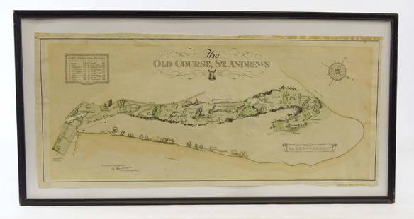
Sold2019Scotland Early Golf MapOld Course St. Andrews Map. Surveyed by A. MacKenize Architect, 1924. McCorquodale & Co., Glasgow, C. 1924. Sight 10 3/4" x 24 1/2".See Sold Price
Sold2021Charleston South Carolina mapCharleston South Carolina map surveyed by Charles Vignoles & Henry Ravenel 1820 I proved for mills atlas 38 inches x 35 inchesSee Sold Price
Sold20191784 Cadell Map of the Caspian Sea Region -- Chart ofTitle/Content of Map: 1784 Cadell Map of the Caspian Sea Region -- Chart of the Caspian Sea Date: 1784, London Cartographer: T CadellSize: 7.5 x 6.3 in. A very nice map of the then recently explored cSee Sold Price
Sold2024Partie Méridionale de la Louisiane… Floride. SANTINI / D'ANVILLE 1784 mapTitle: "Partie Méridionale de la Louisiane…" Floride. SANTINI / D'ANVILLE 1784 map Description: Partie Méridionale de la Louisiane, avec la Floride, la Caroline et la Virginie par le SSee Sold Price
Sold20191784 Map of the Friendly IslandsA map of the Friendly Islands published by Alex. Hogg, London, circa 1784. Trim to top margin, very good, measures 14 x 9.5”. Reserve: $20.00 Shipping: Domestic: Flat-rate of $5.00 to anywhere withiSee Sold Price
Sold20191784 Map of Hungary Transylvania CroatiaFolding map of Hungary Transilvania Sclavonia Croatia published by Harrison and Co., 1784. Fine measures 16.5 x 10". Reserve: $10.00 Shipping: Domestic: Flat-rate of $5.00 to anywhere within the contiSee Sold Price
Sold2017150 plus loose plates from Breou's Farm Maps of Chester150 plus loose plates from Breou's Farm Maps of Chester County, Pennsylvania, WH Kirk, Philadelphia, 1883, with a bindingSee Sold Price
Sold2017Breou's Farm Maps of Chester County, Pennsylvania, WHBreou's Farm Maps of Chester County, Pennsylvania, WH Kirk, Philadelphia, 1883, unbound at spine, edges good-very good, full, boards fair-good, but may not contain all platesSee Sold Price
Sold2017Breou's Farm Maps of Chester County, Pennsylvania, WHBreou's Farm Maps of Chester County, Pennsylvania, WH Kirk, Philadelphia, 1883, taped at spine, edges good-very good, full, boards fair-good, but may not contain all platesSee Sold Price
Sold2017Breou's Farm Maps of Chester County, Pennsylvania, WHBreou's Farm Maps of Chester County, Pennsylvania, WH Kirk, Philadelphia, 1883, intact spine, edges good-very good, full, boards fair-good, but may not contain all platesSee Sold Price
Sold2017Breou's Farm Maps of Chester County, Pennsylvania, WHBreou's Farm Maps of Chester County, Pennsylvania, WH Kirk, Philadelphia, 1883, unbound at spine, edges tattered, losses to boards, full, but may not contain all platesSee Sold Price
Sold20221862 Town of Montgomery Pictorial MapDated 1862 Town of Montgomery Pictorial Farm Map in Gd. Cond. w/ Frame 38"H x 55"W -38in.H.x55in.W. w/FrameSee Sold Price
Sold2024Kitchin Map of the World with the New Discoveries on Mercator's Projection 1783KITCHIN, Thomas (1718-1784)). Map of the World with the New Discoveries on Mercator's Projection. Engraved map. London: Cadell, 1783. 14 3/4" x 20 7/8" sheet. This map presents an interesting view ofSee Sold Price
Sold2017Thomas Kitchin, Maryland and Scotland maps(Scottish, 1718-1784)., "Map of Maryland with the Delaware counties and the southern part of New Jersey," hand colored map, circa 1750, 7 x 9 in. , framed and "Scotland," circa 1760, 7 1/2 x 9 in. , fSee Sold Price
Sold2018Map, United States, 1784, first map of the nationMap, United States, 1784,"Carte Des Etats-Unis De L'Amerique Suivant le Traite de Paix de 1783. Dediee et Presentee A.S. Excellence M. Benjamin Franklin Ministre Pleinipotentaire des Etats-Unis", theSee Sold Price
Sold2022KENT – LYDD – MANUSCRIPT ESTATE MAP 'A Map of a Farm lying in the Parish of Lydd in ...KENT – MANUSCRIPT ESTATE PLAN 'A Map of a Farm lying in the Parish of Lydd in the County of Kent Belonging to the Reverd. Mr Richard Monins 1774.', manuscript map by Henry Maxted & Isaac Terry,See Sold Price
Sold2017de la Rochette/Faden: Antique Map Lesser Antilles, 1784Map: A Chart of the Antilles, or: Charibbee, or: Caribs Islands, with the Virgin Isles Cartographer: De la Rochette/Faden Place & Date: London / 1784 Size: 18" x 20 3/8" Condition: b&w (except for wasSee Sold Price
Sold202319thC "Historical Map of Nantucket Surveyed and Drawn by The Rev. E.C. Ewer 1869" - overall framed19thC "Historical Map of Nantucket Surveyed and Drawn by The Rev. E.C. Ewer 1869" - overall framed size 10"x14"See Sold Price
Sold20241920's World Map and Rural Life and Farm Stock Map of NY1920's World map with world leaders, rural life and farm stock journal map of New YorkSee Sold Price
Sold20211784 Bowen Map of Greater London -- A New & Correct MapTitle: 1784 Bowen Map of Greater London -- A New & Correct Map of the Counties upwards of Twenty Miles Round London, Drawn from Modern Surveys and Engrav'd for Thornton's History of London &c. CartogrSee Sold Price
Sold20191784 Folding Map of Persia1784 “A New Map of Persia by J. Bayly”, published by Harrsion and Co., London. Folding map measuring 10 x 15”, Fine condition. Reserve: $30.00 Shipping: Domestic: Flat-rate of $5.00 to anywhereSee Sold Price
Sold20201784 Large Map of GermanyA Correct Map of the North West part of Germany…. published by Harrison and Co., London, 1784. Fine, folding, measures 21 x 16.5". Reserve: $30.00 Shipping: Domestic: Flat-rate of $7.00 to anywhereSee Sold Price
4 days LeftJasper52l'Arménie, la Géorgie et la Daghistan Caucasus. SANTINI/RIZZI-ZANNONI 1784 map$120
4 days LeftJasper52Les Royaumes de Suede et Norwege…. Scandinavia. SANTINI / JANVIER 1784 map$100
4 days LeftJasper52Gli Stati del Piemonte e Savoja. Savoie. French & Italian Alps. ZATTA 1784 map$130
5 days LeftZikorn Arts & History ObjectsWest Indies, Cape Gracias to Belize 1843 British Admiralty Map$100
5 days LeftZikorn Arts & History ObjectsWest Indies, Western Cuba 1879 British Admiralty Nautical Map$100
5 days LeftZikorn Arts & History ObjectsWest Indies Pt. Manzanilla to San Juan 1844 British Admiralty Map$100
May 30Forum AuctionsMidnight Paper Sales.- Verhoeven (Ben) Sylvae: Fifty Specimens printed directly from the wood with£650
3 days LeftFleischer's Auctions1755 Map Partie de l'Amerique Septentrionale, qui comprend Le Cours de L'Ohio...$200(3 bids)
2 hrs LeftCrescent City Auction GalleryWilliam H. Williams (1817-1886), New Orleans "Map of the Sixth District and Carrollton," 1871, H.-$650
May 18Rich Penn AuctionsNeon Farm Dealer Clock & Riden Farm Supply marquee, mfgd by Electric Neon Clock Co.-Cleveland, OH, b$1,100(6 bids)
May 18Rich Penn AuctionsJohn Deere Farm Implements Sign w/2-legged leaping deer, very colorful tin, c.1970's by Veribrite$225(4 bids)