Sold2022Plan of St. Andrews Links Booklet with MapEarly booklet with folding map Plan of Golf Courses, showing Old, New and Jubilee Courses. Robert Forgan & Son, Scotland ad inside front cover. Early manuscript note verso. Rare book pocket map cartogSee Sold Price
Sold2017Bellin: Plan of Malacca City/Tonkin River Basin ChartMap: Plan de la Ville et Forteresse de Malaca [and on the same sheet] Carte du Cours de la Riviere de Tunquin [Tonkin] Depuis Cacho jusqu'a la Mer Cartographer: Bellin Place & Date: Paris / 1750/1760See Sold Price
Sold2021Scarce SDUK map of New York City, 1840Elusive vintage 1840 Society for the Diffusion of Useful Knowledge (S.D.U.K.) city map or plan of New York City. Shows southern Manhattan from the Battery northwards to 42nd Street and portions of adjSee Sold Price
Sold2021Alexandre Vuillemin, Plan Pittoresque de ParisAlexandre Vuillemin, Plan Pittoresque de Paris (1840). large, linen-backed folding map.Estimate: $100 - $200See Sold Price
Sold20201840 Nichol Map of Aberdeen -- AberdeenTitle/Content of Map: 1840 Nichol Map of Aberdeen -- Aberdeen Cartographer: J & D Nichol Year/Place: 1840, Edinburgh Size: 13.6 X 18.9 in. A handsome plan of Aberdeen, Scotland. Great deal of detail aSee Sold Price
Sold2019MAP - Philadelphia, Pennsylvania. SDUKPhiladelphia, Pennsylvania. SDUK Society for the Diffusion of Useful Knowledge, Philadelphia, 1840 (dated). Hand Color. This is one of the best 19th century plans of Philadelphia. It shows the city ceSee Sold Price
Sold2017Harrison: Antique Map Plan of London, 1776Title/Content of Map: 'A new and complete plan of London, Westminster and Southwark, with the additional buildings to the year 1777' Date Printed: 1776 Image Size: Approx 29.5 x 51.0cm, 11.5 x 20 inchSee Sold Price
Sold2017Munster: Antique Map Plan of Cusco, 1550Map: Die Statt Cusco Cartographer: Sebastian Munster Place & Date: Basle / 1550 Size: 14 3/4" x 10 5/8" Condition: B&W; overall age toning; some browning along centerfold and outer edges of margins; aSee Sold Price
Sold2023L'Africa. DE ROSSI / SANSON 1677 old antique vintage map plan chartTITLE/CONTENT OF MAP: L'Africa [Africa] DATE PRINTED: 1677 IMAGE SIZE: Approx 42.5 x 57.0cm, 16.75 x 22.25 inches (Large) TYPE: Antique 17th century folio atlas map CONDITION: Good; suitable for framiSee Sold Price
Sold2020PARIS antique town city map plan. Building profiles.TITLE/CONTENT OF MAP: 'PARIS' DATE PRINTED: This map was originally published by Baldwin & Cradock in 1834; this date is printed on the map. This edition of the map was printed and published by ChapmaSee Sold Price
Sold2024L'Irlanda o'vero Hibernia. Ireland. DE ROSSI 1689 old antique map plan chartTITLE/CONTENT OF MAP: L'Irlanda o'vero Hibernia [Ireland, or Hibernia] DATE PRINTED: 1689 IMAGE SIZE: Approx 59.0 x 45.0cm, 23.25 x 17.75 inches (Large) TYPE: Antique 17th century folio atlas map CONDSee Sold Price
Sold2019MOSCOW MOSKAU antique town city map plan & panorama.TITLE/CONTENT OF MAP: 'MOSCOW' DATE PRINTED: This map was originally published by Baldwin & Cradock in 1836; this date is printed on the map. This edition of the map was printed and published by ChapmSee Sold Price
Sold2020Framed 1867 Map/Plan of Baltimore - Entered accordingFramed 1867 Map/Plan of Baltimore - Entered according to Act of Congress in the year 1867 by S. Augustus Mitchell in the Clerks Office of the District Court for the Eastern District of PennsylvaniaSee Sold Price
Sold202418th c. Siege Map/PlanAn attractive hand-colored manuscript plan of siege by the King of Sardinia. Ca. 18th century. On laid sheet with watermark, 14.75" x 10.5".See Sold Price
Sold2021Maps, Plans, Views and Coins Travels of Anacharsis theMaps, Plans, Views and Coins Illustrative of the Travels of Anacharsis the Younger in Greece, during the middle of the fourth century before the christian aera. Vol VIII, Second Edition. Published LonSee Sold Price
Sold20211825 Plan of Yorktown in Virginia & Adj Country1825 Map, Plan of Yorktown in Virginia and Adjacent Country, Exhibiting the operations of the American French & English armies, during the Siege of that place in Oct. 1781. Sheet is irregularly trimmeSee Sold Price
Sold2017Levasseur: Antique Map of North America, 1840Title/Content of Map: 1840 Levasseur Map of North America - Amerique Septrentionale Date Printed: 1840 Paris Cartographer: V. Levasseur Size: 11 x 16.5 in. Condition: Excellent. Minor age toning; issuSee Sold Price
Sold2024▲ Doris Zinkeisen (1898-1991)▲ Doris Zinkeisen (1898-1991) 'Newmarket Heath' signed 'Doris Zinkeisen' l.r., oil on canvas 51 x 101cm Provenance: With Frost & Reed. Condition Report: Framed: 66 x 116cm Light surface dirt. SoSee Sold Price
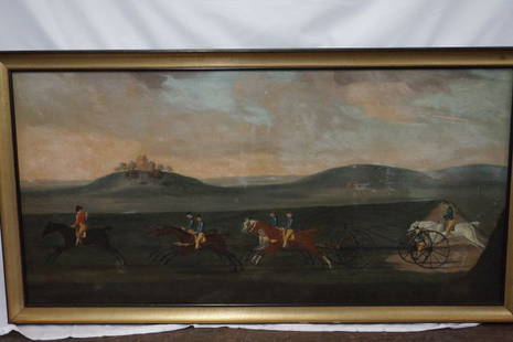
Sold2015After James Seymour 1702-1752 "A Carriage Match"After James Seymour 1702-1752 "A Carriage Match against time, ran on Newmarket Heath, August 1750" Oil on canvas, After James Seymour (British, b.1702, d.1752) No visible signature, Molded gold and blSee Sold Price
Sold2016Map of Port Royal Harbour Carolina by Herman Moll 1730Map: Plan of Port Royal Harbour in Carolina Maker: Herman Moll Date: 1730-32 Size: 8 x 10.5 inches Hilton Head and Port Royal, South Carolina. Moll notes on the map that it is "the best Country in CarSee Sold Price
Sold20191715, King James Bible, Folio, Large Pulpit Size1715, FOLIO KING JAMES BIBLE VERSION WITH GENEVA NOTES 16" x 10". [28], 712, [2], 160, 248 pp. (text complete), + 2 (of 6) double-page maps/plans by Moxon Including plan of Jerusalem and map of CanaSee Sold Price
Sold2021Mitchells New Universal AtlasDated 1850. 14.5 x 17.5. 129 maps, plans, and sections.See Sold Price
Sold20221708 ALEXANDER THE GREAT HISTORY ARMORIAL VELLUM BINDING antique ILLUSTRATEDCurtius Rufus G. Alexander Magnus. Ed. S. Pitiscus. The Hague, P. van Thol, 1708 (68),855,(169)p. Engraved frontispiece by J. VAN DEN AVELEN after G. HOET, 16 engravings, folding maps/ plans/ views anSee Sold Price
Sold2022Public Health.- Houses of Parliament. First [-Third] Report of the Commissioners...into...PreventingPublic Health.- Houses of Parliament. First Report of the Commissioners...into...the Best Means of Preventing the Pollution of Rivers (River Thames), 2 vol., 12 maps & plans, most folding including laSee Sold Price
2 days LeftJasper52The Right Reverend Father in God, Dr. Benjamin Hoadly, after Hogarth. Heath Edition, 1822$100
3 days LeftDoyle New YorkThe top sheet of the famous Ratzer Map - with additions relating to an 1810 real estate dispute$7,500
May 16Potter & Potter AuctionsMap to Acquaint You with the Great Mission Bay Project. 194...$125(1 bid)


![Bellin: Plan of Malacca City/Tonkin River Basin Chart: Map: Plan de la Ville et Forteresse de Malaca [and on the same sheet] Carte du Cours de la Riviere de Tunquin [Tonkin] Depuis Cacho jusqu'a la Mer Cartographer: Bellin Place & Date: Paris / 1750/1760](https://p1.liveauctioneers.com/5584/105261/53910605_1_x.jpg?height=310&quality=70&version=1497542970)


![L'Africa. DE ROSSI / SANSON 1677 old antique vintage map plan chart: TITLE/CONTENT OF MAP: L'Africa [Africa] DATE PRINTED: 1677 IMAGE SIZE: Approx 42.5 x 57.0cm, 16.75 x 22.25 inches (Large) TYPE: Antique 17th century folio atlas map CONDITION: Good; suitable for frami](https://p1.liveauctioneers.com/5584/308981/165185503_1_x.jpg?height=310&quality=70&version=1699996168)

![L'Irlanda o'vero Hibernia. Ireland. DE ROSSI 1689 old antique map plan chart: TITLE/CONTENT OF MAP: L'Irlanda o'vero Hibernia [Ireland, or Hibernia] DATE PRINTED: 1689 IMAGE SIZE: Approx 59.0 x 45.0cm, 23.25 x 17.75 inches (Large) TYPE: Antique 17th century folio atlas map COND](https://p1.liveauctioneers.com/5584/326140/175577116_1_x.jpg?height=310&quality=70&version=1713288521)


![1715, King James Bible, Folio, Large Pulpit Size: 1715, FOLIO KING JAMES BIBLE VERSION WITH GENEVA NOTES 16" x 10". [28], 712, [2], 160, 248 pp. (text complete), + 2 (of 6) double-page maps/plans by Moxon Including plan of Jerusalem and map of Cana](https://p1.liveauctioneers.com/6752/145177/73447828_1_x.jpg?height=310&quality=70&version=1562055217)


![Public Health.- Houses of Parliament. First [-Third] Report of the Commissioners...into...Preventing: Public Health.- Houses of Parliament. First Report of the Commissioners...into...the Best Means of Preventing the Pollution of Rivers (River Thames), 2 vol., 12 maps & plans, most folding including la](https://p1.liveauctioneers.com/5458/260724/135800356_1_x.jpg?height=310&quality=70&version=1662479034)


