Sold2017Meyer: Antique Map of Mexico & Independent Texas, 1845Map: Neueste Karte von Mexico Cartographer: Bibliographischen Instituts. Place & Date: Hildburghausen / 1845 Size: 14 1/8" x 11 3/8" Condition: original outline color; overall age toning; water stainsSee Sold Price
Sold2017SDUK: Antique Map of Southwestern USA, 1846CENTRAL AMERICA, SHEET II., INCLUDING TEXAS, CALIFORNIA AND THE NORTHERN STATES OF MEXICO' The map, published in 1846, shows the Republic of Texas as an independent state as it existed between 1836 anSee Sold Price
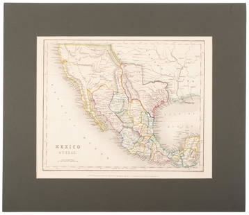
Sold2020Mexico with a large independent Texas, c.1845 mapHeading: Author: Gilbert, James Title: Mexico & Texas Place Published: London Publisher:Grattan & Gilbert Date Published: c.1845 Description: Engraved map, hand-colored in outliSee Sold Price
Sold2022Mexico, shows a independent Republic of Texas. Important S.W region map. 1846 by A and C BlackMexico with a independent Republic of Texas, shown at its largest territorial expanse. Although Texas would join the Union in 1845, this map was published in 1846 but was not updated in time making itSee Sold Price
Sold2018Meyer: Antique Map of Alabama, 1845Map: Neueste Karte von Alabama Cartographer: Bibliographischen Instituts. Place & Date: Hildburghausen / 1845 Size: 11 3/4" x 14 5/8" Condition: original outline color; minor spotting and a repaired tSee Sold Price
Sold2018Meyer: Antique Map of Pennsylvania, 1845Neueste Karte von Pennsylvania The beautifully detailed and colored map of Pennyslvania "with its canals, railroads, etc.," from the 1856 edition of Meyer's Hand-Atlas. Includes a profile of PennsylvaSee Sold Price
Sold2022(REPUBLIC OF TEXAS.) John M. Niles; and Lorraine T. Pease. A Map of Mexico and the Republic of(REPUBLIC OF TEXAS.) John M. Niles; and Lorraine T. Pease. A Map of Mexico and the Republic of Texas. Hand-colored engraved map of Mexico, an independent Texas, and part of the American southeast. 13&See Sold Price
Sold2018Meyer: Antique Map of New Hampshire/Vermont, 1845Map: Neueste Karte von New Hampshire und Vermont Cartographer: Bibliographischen Instituts. Place & Date: Hildburghausen / 1845 Size: 11 3/4" x 14 3/4" Condition: original outline color; light overallSee Sold Price
Sold20221747 Mexico, California, New Mexico, Texas Original Antique Map by Emanuel Bowen1747 Mexico, California, New Mexico, Texas Original Antique Map by Emanuel BowenSee Sold Price
Sold2018LaPie / Tardieu: Antique Map of US, Texas, Mexico, 1809Map: Mexique Cartographer: P. LaPie / Tardieu Place & Date: Paris / 1809/1812 Size: 11 7/8" x 8 3/4" Condition: outline color; light overall age toning, otherwise beautifully preserved A detailed mapSee Sold Price
Sold2020Map of Mexico and Texas c.1845Heading: (Texas) Author: Wyld, James Title: Republic of Mexico and Texas Place Published: London Publisher: Date Published: c.1845 Description: Engraved map, with Mexico portionSee Sold Price
Sold2018Radefeld/Meyer: Antique Map of U.S. & Mexico, 1852Vereinigte Staaten von Nord-America und Mexico. A highly detailed map of the United States and Mexico from Meyer's Groschen-Atlas, showing the pre-Gadsen Purchase border between the U.S. and Mexico anSee Sold Price
Sold2018Antique Map of Southwestern US & MexicoTitle/Content of Map: Important Southwestern U.S., Texas to CA with Mexico and Guatemala Date Printed: 1843 Cartographer: Based on the work of H.C. Tanner Material/Medium: Paper Size: 17" x 14" Hand cSee Sold Price
Sold2018SDUK: Antique Map of the Americas, Gnomonic ProjectionAMERICAS. Gnomonic Projection. Texas Republic borders. USA Mexico. The map was originally engraved prior to or during the Texas Republic, and borders on the map have been drawn to show Texas as beingSee Sold Price
Sold2022Map of North America with Independent TexasSteel-engraved map of North America with Texas shown as an independent country, hand-colored in outline. Published by T. Tegg, London, circa 1845. [10" H x 8 1/2" W]. Slightly toned, near fine.See Sold Price
Sold2020Meyer's U.S. with Texas an independent country 1845Heading: (Texas) Author: Meyer, Joseph Title: Nord-Americanische Freistaaten 1845 Nach den besten Quellen entworf. u. gezeich. v. Hauptm. C. Radefeld Place Published: Hildburghausen Publisher:BibliogrSee Sold Price
Sold2022Antique 19th C. Ohio Map, J. Meyer (German) 1845An original steel engraved atlas map "Neuste Karte von Ohio mit seinen Canaelen, Strassen & Entfernungen der Hauptpunkte. Nach den bessten Quellen verbessert. 1845" Joseph Meyer (German, 1See Sold Price
Sold2022SOUTH WESTERN USA. Showing Republic of Texas & Mexican California. SDUK 1851 mapTITLE/CONTENT OF MAP: 'CENTRAL AMERICA, SHEET II., INCLUDING TEXAS, CALIFORNIA AND THE NORTHERN STATES OF MEXICO' The map shows the Republic of Texas as an independent state as it existed between 1836See Sold Price
Sold2019SOUTH WESTERN USA.Showing Republic of Texas & MexicanReserve Reduced! TITLE/CONTENT OF MAP: 'CENTRAL AMERICA, SHEET II., INCLUDING TEXAS, CALIFORNIA AND THE NORTHERN STATES OF MEXICO' The map shows the Republic of Texas as an independent state as it exiSee Sold Price
Sold2018SDUK: Antique Map of Europe, 1845TITLE/CONTENT OF MAP: 'EUROPE; inset table of population by country' The map shows Lombardia-Venetia as part of the Austrian Empire, the independent Ionian Islands, and Turkish Crete DATE PRINTED: 184See Sold Price
Sold2024Tanner's North America independent TexasHeading: (North America) Author: Tanner, Henry Schenck Title: North America Place Published: Philadelphia Publisher: Date Published: 1836-[1845] Description: Engraved map, hand-coloSee Sold Price
Sold2020North America with independent TexasHeading: Author: Dufour, Adolphe Hippolyte Title: [Amerique du Nord] Place Published: [Paris] Publisher:Imp. de N. Rémond Date Published: c.1845 Description: Engraved map, hand-See Sold Price
Sold2017Johnston: Antique Map of North America, 1845Map: North America. Texas Republic in Largest Format Publication Date: 1845 Authors: JOHN JOHNSTONE AND W. & A.K. JOHNSTON, JOHNSTON, A. K. Publisher: JOHN JOHNSTONE AND W. & A.K. JOHNSTON Size: FolioSee Sold Price
Sold2020Tanner's North America independent TexasHeading: (Texas) Author: Tanner, Henry Schenck Title: North America Place Published: Philadelphia Publisher: Date Published: 1836-[1845] Description: Engraved map, hand-coloSee Sold Price
Jun 02Schilb Antiquarian Rare Books1849 TEXAS 1ed Mexican War Porter Annexation Mexico Americana Peace Treaties$2(2 bids)
22 hrs LeftJasper521775-1780 Southwest (Arizona, New Mexico, Texas, with most of Mexico) by Bonne & Raynal$160(1 bid)
2 days LeftJasper52Central America Caribbean Gulf of Mexico chart Ports lighthouses LARGE 1918 map$45
Featured2 days LeftJasper52MEXICO CENTRAL AMERICA WEST INDIES. Panama & Proposed Nicaragua canals 1912 map$35
2 days LeftJasper52CENTRAL AMERICA & CARIBBEAN. West Indies Mexico &c. Inset Panama Canal 1890 map$20
2 days LeftJasper52West Indies. Caribbean islands Antilles Gulf of Mexico Florida. THOMSON 1830 map$150
May 17Albion AuctionsMarmocchi, F. C. 1845 Hand Col Map. Holy Land. Persia Empire, Alexander the Great$5


![Map of North America with Independent Texas: Steel-engraved map of North America with Texas shown as an independent country, hand-colored in outline. Published by T. Tegg, London, circa 1845. [10" H x 8 1/2" W]. Slightly toned, near fine.](https://p1.liveauctioneers.com/1221/243451/126278661_1_x.jpg?height=310&quality=70&version=1649868014)


![Tanner's North America independent Texas: Heading: (North America) Author: Tanner, Henry Schenck Title: North America Place Published: Philadelphia Publisher: Date Published: 1836-[1845] Description: Engraved map, hand-colo](https://p1.liveauctioneers.com/642/319971/171838592_1_x.jpg?height=310&quality=70&version=1708136548)
![North America with independent Texas: Heading: Author: Dufour, Adolphe Hippolyte Title: [Amerique du Nord] Place Published: [Paris] Publisher:Imp. de N. Rémond Date Published: c.1845 Description: Engraved map, hand-](https://p1.liveauctioneers.com/642/174090/87617771_1_x.jpg?height=310&quality=70&version=1595023143)

![Tanner's North America independent Texas: Heading: (Texas) Author: Tanner, Henry Schenck Title: North America Place Published: Philadelphia Publisher: Date Published: 1836-[1845] Description: Engraved map, hand-colo](https://p1.liveauctioneers.com/642/171046/86179542_1_x.jpg?height=310&quality=70&version=1591835061)


