Sold2020Mexico with a large independent Texas, c.1845 mapHeading: Author: Gilbert, James Title: Mexico & Texas Place Published: London Publisher:Grattan & Gilbert Date Published: c.1845 Description: Engraved map, hand-colored in outliSee Sold Price
Sold2017Meyer: Antique Map of Mexico & Independent Texas, 1845Map: Neueste Karte von Mexico Cartographer: Bibliographischen Instituts. Place & Date: Hildburghausen / 1845 Size: 14 1/8" x 11 3/8" Condition: original outline color; overall age toning; water stainsSee Sold Price
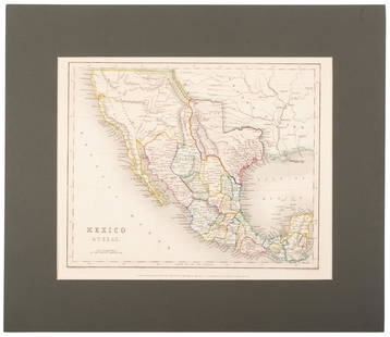
Sold2020Map of Mexico and Texas c.1845Heading: (Texas) Author: Wyld, James Title: Republic of Mexico and Texas Place Published: London Publisher: Date Published: c.1845 Description: Engraved map, with Mexico portionSee Sold Price
Sold2022(REPUBLIC OF TEXAS.) John M. Niles; and Lorraine T. Pease. A Map of Mexico and the Republic of(REPUBLIC OF TEXAS.) John M. Niles; and Lorraine T. Pease. A Map of Mexico and the Republic of Texas. Hand-colored engraved map of Mexico, an independent Texas, and part of the American southeast. 13&See Sold Price
Sold2020North America with large independent TexasHeading: Author: Burgess, Daniel Title: Map of North America Designed to Accompany Smith's Geography for Schools Place Published: New York Publisher: Date Published: 1839 Description:See Sold Price
Sold2022Mexico, shows a independent Republic of Texas. Important S.W region map. 1846 by A and C BlackMexico with a independent Republic of Texas, shown at its largest territorial expanse. Although Texas would join the Union in 1845, this map was published in 1846 but was not updated in time making itSee Sold Price
Sold2020United States with large independent TexasHeading: (Texas) Author: Chambers, W. & R. Title: United States Place Published: Edinburgh Publisher: Date Published: 1841 Description: Engraved map, hand-colored in outlineSee Sold Price
Sold2018Spanish North America. THOMSON. Texas, Mexico &TITLE/CONTENT OF MAP: 'Spanish North America [northern part]' A large map of Texas, Mexico and the American Southwest, published in Edinburgh by John Thompson, based on the explorations of Humboldt anSee Sold Price
2024Spanish North America. THOMSON. Texas, Mexico & Southwestern USA 1817 mapTITLE/CONTENT OF MAP: Spanish North America [northern part] A large map of Texas, Mexico and the American Southwest, published in Edinburgh by John Thompson, based on the explorations of Humboldt andSee Sold Price
Sold2023Spanish North America. THOMSON. Texas, Mexico & Southwestern USA 1830 mapTITLE/CONTENT OF MAP: Spanish North America [northern part] A large map of Texas, Mexico and the American Southwest. There are extensive observations of Native American Indian settlements and huntingSee Sold Price
Sold2020North America with independent TexasHeading: Author: Dufour, Adolphe Hippolyte Title: [Amerique du Nord] Place Published: [Paris] Publisher:Imp. de N. Rémond Date Published: c.1845 Description: Engraved map, hand-See Sold Price
Sold2019N. Amer. map w/huge Texas, New Calif. Terr.Reserve Reduced! Interesting map of North America showing a huge Texas, large Oregon Territory and New California. Dates to at least 1850 because that’s when New Mexico became a territory. Drawn andSee Sold Price
Sold2019U S Coast Survey 1896 LG Map. New Orleans Texas Florida"Sketch of General Progress June 30. 1896" Showing Southern, Eastern and Mid West States, incl Florida, Texas, Gulf of Mexico, Georgia etc. Large Lithograph Map Published 1896, Washington for "U.S. CoSee Sold Price
Sold2022SOUTH WESTERN USA. Showing Republic of Texas & Mexican California. SDUK 1851 mapTITLE/CONTENT OF MAP: 'CENTRAL AMERICA, SHEET II., INCLUDING TEXAS, CALIFORNIA AND THE NORTHERN STATES OF MEXICO' The map shows the Republic of Texas as an independent state as it existed between 1836See Sold Price
Sold2019SOUTH WESTERN USA.Showing Republic of Texas & MexicanReserve Reduced! TITLE/CONTENT OF MAP: 'CENTRAL AMERICA, SHEET II., INCLUDING TEXAS, CALIFORNIA AND THE NORTHERN STATES OF MEXICO' The map shows the Republic of Texas as an independent state as it exiSee Sold Price
Sold2020County Map of the State of Texas, 1886Excellent and detailed map of Texas colored by county and showing most of Indian Territory and New Mexico. In this map the Texas counties are still incomplete in the West. Features a large inset planSee Sold Price
Sold2017SDUK: Antique Map of Southwestern USA, 1846CENTRAL AMERICA, SHEET II., INCLUDING TEXAS, CALIFORNIA AND THE NORTHERN STATES OF MEXICO' The map, published in 1846, shows the Republic of Texas as an independent state as it existed between 1836 anSee Sold Price
Sold20211844 map of the U. S., Canada & MexicoGreat map of the United States showing Texas in a very large configuration, otherwise known as the “Stovepipe” shape, with its northern border going all the way into what would become the state ofSee Sold Price
Sold2019U S Coast Survey 1896 LG Map. West USA California Texas"Sketch of General Progress June 30. 1896." Showing Central and Western US, with part of Mexico. From Mississippi/Wisconsin through to West Coast. Large Lithograph Map Published 1896, Washington for "See Sold Price
Sold2018North AmericaTitle/Content of Map: North America Date Printed: 1851 ca. Cartographer: SWANSTON, G. H. Size: 10.6X8.5 Very large Oregon, Utah and New Mexico territories. Texas has present boundaries. Margins browneSee Sold Price
Sold2016Map of the United States 1835Map: Map of the United States Maker: Anonymous Size: Folio - 11.2 inches high x 14.6 inches wide Date: 1835 Map covering U.S. west to Rocky Mtns. Large NW Terr.; huge MO Terr. Texas part of Mexico asSee Sold Price
Sold2023Scarce 1701 1st ed. map of Florida, western America & MexicoAn uncommon map of Florida and the areaAn uncommon map of Florida and the area encompassing Texas and the American West, with the whole of Mexico and Central America. Of note is California, which at this time was considered a large island.See Sold Price
Sold20191887 Page Co. Map of Texas -- Map of TexasReserve Reduced! Title/Content of Map: 1887 Page Co. Map of Texas -- Map of Texas Date: 1887 Chicago Cartographer: H. R. Page & Co. Size: 26 X 16.5 in. This large Texas map is a rare issue by the littSee Sold Price
Sold2023CARL FLEMMING (c. 1840-1879) A REPUBLIC OF TEXAS MAP, "Mexico, Mittel America, Texas," GLOGAU, CIRCACARL FLEMMING (c. 1840-1879) A REPUBLIC OF TEXAS MAP, "Mexico, Mittel America, Texas," GLOGAU, CIRCA 1846, a German lithograph on paper with hand color showing territories claimed by the Republic of TSee Sold Price
Jun 23Schilb Antiquarian Rare Books1848 Emory Military Reconnaissance 1ed California MAP Indians Texas New Mexico$2(2 bids)
Jun 02Schilb Antiquarian Rare Books1849 TEXAS 1ed Mexican War Porter Annexation Mexico Americana Peace Treaties$88(4 bids)
7 hrs LeftJasper52Sketch Showing the Progress of the Survey On The Atlantic, Gulf of Mexico and Pacific Coasts Of The$25
1 day LeftJasper52La Tartaria Indipendente… Central Asia, Caspian Sea & Caucasus. ZATTA 1785 map$100(1 bid)
Jun 02Schilb Antiquarian Rare Books1848 RARE Halls of Montezumas MEXICO Texas America War Zachary Taylor Battles$5(4 bids)
Jun 09Austin Auction GalleryGLENNA GOODACRE (TX, 1939-2020) BRONZE MAQUETTE, 'PHILOSOPHER'S ROCK'$1,500(1 bid)


![Spanish North America. THOMSON. Texas, Mexico &: TITLE/CONTENT OF MAP: 'Spanish North America [northern part]' A large map of Texas, Mexico and the American Southwest, published in Edinburgh by John Thompson, based on the explorations of Humboldt an](https://p1.liveauctioneers.com/5584/132181/67157544_1_x.jpg?height=310&quality=70&version=1543975692)
![Spanish North America. THOMSON. Texas, Mexico & Southwestern USA 1817 map: TITLE/CONTENT OF MAP: Spanish North America [northern part] A large map of Texas, Mexico and the American Southwest, published in Edinburgh by John Thompson, based on the explorations of Humboldt and](https://p1.liveauctioneers.com/5584/320546/172232524_1_x.jpg?height=310&quality=70&version=1709072904)
![Spanish North America. THOMSON. Texas, Mexico & Southwestern USA 1830 map: TITLE/CONTENT OF MAP: Spanish North America [northern part] A large map of Texas, Mexico and the American Southwest. There are extensive observations of Native American Indian settlements and hunting](https://p1.liveauctioneers.com/5584/309982/165835454_1_x.jpg?height=310&quality=70&version=1700599538)
![North America with independent Texas: Heading: Author: Dufour, Adolphe Hippolyte Title: [Amerique du Nord] Place Published: [Paris] Publisher:Imp. de N. Rémond Date Published: c.1845 Description: Engraved map, hand-](https://p1.liveauctioneers.com/642/174090/87617771_1_x.jpg?height=310&quality=70&version=1595023143)


