Sold20172 HARD BOUND COFFEE TABLE BOOKS2 HARD BOUND COFFEE TABLE BOOKS - BIRDS OF PREY OF THE WORLD - 70 FULL COLOR ILLISTRUTIONS - 283 DUO TONES - 646 SILHOUTTES - 425 RANGE MAPS - NATIONAL GEOGRAPHIC ATLAS OF THE WORLD 8TH EDITION - COMESee Sold Price
Sold20241828 School Atlas Published by Cummings and Hillard at The Boston BookstoreSchool Atlas to Cummings' Ancient and Modern Geography. 8th edition. Published by Cummings and Hillard at The Boston Bookstore. This atlas is depicted by prints of different parts of the world throughSee Sold Price
Sold20242014 Standard Catalog of World Coins 2001-Date 8th Edition By George S Cuhaj2014 Standard Catalog of World Coins 2001-Date 8th Edition By George S Cuhaj. All Prices At Least 15% Below RetailSee Sold Price
Sold2019Scribner-Black World Atlas, Library Edition, C1889Scribner-Black World Atlas, Library Edition, C1889. Color maps. Leather bound. 19 inches x 14 inchesSee Sold Price
Sold2022NATGEO Vintage Atlas of The World BookNATGEO Vntg Atlas of The World Book, copyright to 1981, measures 12 1/4 x 18 1/2 inches. Books, literature, coffee table looks, literature, adult literature, coffee table literature, NATGEO, NationalSee Sold Price
Sold2024MID-CENTURY ILLUMINATED GLASS GLOBEwith Rand McNally World Atlas c1945. Replogle illuminated glass globe on a base with a single compartment containing a 1945 edition of the Rand McNally World Atlas Readers Edition. 16 inch height, basSee Sold Price
Sold2018Autographed Copy of the Important WWI Book Entitled "AA Limited Autographed Edition of "The People's War Book & Pictorial Atlas of the World | Autographed Edition | A history, cyclopedia and chronology of the Great World War | James Martin Miller; H.See Sold Price
Sold202430's Atlas of the World & Crossing by ChurchillThe Modern Complete Atlas of the World Academic Edition, published by the John C Winston Company in 1932. The Crossing by Winston Churchill, published by Grosset & Dunlap, 1909. SHIPPING: In-House ShiSee Sold Price
Sold2018Atlas of the World & Blaeu's AtlasAtlas of the World Millennium Edition 15" x 11" x 1"; and Blaeu's The Grand Atlas of the 17th Century World. 1997. 14.5" x 11.25" x 1". We ship most items in-house with the exception of furniture, larSee Sold Price
Sold2022NATIONAL GEOGRAPHIC ATLAS OF THE WORLDNATIONAL GEOGRAPHIC ATLAS OF THE WORLD Fifth edition 1981, third printing 1987. 18 1/2" X 12 1/2" Shipping:See Sold Price
Sold2022National Geographic Atlas of the World BookNational Geographic Atlas of the World Book, inscriptions to cover read ‘National Geographic Atlas of the World Seventh Edition’, measures 18 5/8 x 12 1/4 inches, surface wear to cover, National GSee Sold Price
Sold2021Two Atlases, Rand McNally and National GeographicTwo Atlases, Rand McNally and National Geographic, "National Geographic Atlas of the World, Revised Third Edition" and "Rand McNally & Co's Commercial Atlas of American, Census Edition, 1911" Losses,See Sold Price
Sold2022Antique Map Print - Map of Bohemia - Map of Czech Republic - KingdomAntique outline hand colored map from edition of Meyer’s world atlas, edited by Ludwig Ravenstein, published by Bibliographic Institute in 1872. Technique: Engraving. Place: Leipzig, Germany. SSee Sold Price
Sold20201893 Map of ColoradoTitle: 1893 Map of Colorado Medium: Ink on Paper Dimensions: 14.5"X11.5" Map of Colorado dated 1893. Part of the Standard Atlas of the World, World's Fair Edition. Color coded for territorial divisionSee Sold Price
Sold2019New International Atlas of the World, DeLuxe 1942New International Atlas of the World, DeLuxe 1942 EditionSee Sold Price
Sold2018'39 "COLLIER'S WOLD ATLAS AND GAZETTEER" HARDCOVER1939 edition of "Collier's World Atlas and Gazetteer" large hardcover book. Measures approx. 14 1/2" height x 11 1/4" width x 1 1/8" depth.See Sold Price
Sold2022Original Antique Map -Pommern Provinz - Map of Bornholm Island Baltic SeaAntique outline hand colored map from edition of Meyer’s world atlas, edited by Ludwig Ravenstein, published by Bibliographic Institute in 1872. Technique: Engraving. Place: Leipzig, Germany. SSee Sold Price
Sold2022Original Antique Map - Mecklenburg-Schwerin - Map of Northern GermanyAntique outline hand colored map from edition of Meyer’s world atlas, edited by Ludwig Ravenstein, published by Bibliographic Institute in 1872. Technique: Engraving. Place: Leipzig, Germany. SSee Sold Price
Sold2022Original Antique Map -Bremen Oldenburg - Map of Bremen OldenburgAntique outline hand colored map from edition of Meyer’s world atlas, edited by Ludwig Ravenstein, published by Bibliographic Institute in 1872. Technique: Engraving. Place: Leipzig, Germany. SSee Sold Price
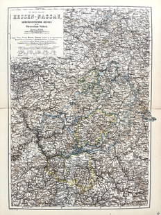
Sold2022Original Antique Map -Hessen Nassau - Map of Furstenthum WaldeckAntique outline hand colored map from edition of Meyer’s world atlas, edited by Ludwig Ravenstein, published by Bibliographic Institute in 1872. Technique: Engraving. Place: Leipzig, Germany. SSee Sold Price
Sold2022Antique Map Print - Map of Schleswig - Holstein - Map of Germany - LauenburgAntique outline hand colored map from edition of Meyer’s world atlas, edited by Ludwig Ravenstein, published by Bibliographic Institute in 1872. Technique: Engraving. Place: Leipzig, Germany. SSee Sold Price
Sold2022Antique Map Print - Map of Mecklenburg-Schwerin - Map of Germany - Roman EmpireAntique outline hand colored map from edition of Meyer’s world atlas, edited by Ludwig Ravenstein, published by Bibliographic Institute in 1872. Technique: Engraving. Place: Leipzig, Germany. SSee Sold Price
Sold2022Original Antique Map - Konicreich Bohmen - Map of Bohmen - Prague - CarlsbadAntique outline hand colored map from edition of Meyer’s world atlas, edited by Ludwig Ravenstein, published by Bibliographic Institute in 1872. Technique: Engraving. Place: Leipzig, Germany. SSee Sold Price
Jun 06Rapid Estate Liquidators and Auction GalleryCollier's World Atlas And Gazetteer Published 1935 & 1936 By P.F. Collier & Son Corporation$5(1 bid)
3 days LeftTrillium Antique Prints & Rare BooksSanson - Map of Canada or New France with the Great Lakes$75(1 bid)
3 days LeftTrillium Antique Prints & Rare BooksSanson - Map of Florida (encompassing most of Southeast North America)$95(2 bids)
4 days LeftJames Auctioneers LondonOsbourne Gemstone World Globe Atlas On Brass Stand-Large Edition!-Rrp £2k.£400
3 days LeftTrillium Antique Prints & Rare BooksSanson - Map of the British Isles (Ireland, Scotland, England)$75
3 days LeftTrillium Antique Prints & Rare BooksBraun & Hogenberg, pub. 1575 - View of Ostia, Italy$140(2 bids)
3 days LeftTrillium Antique Prints & Rare BooksBraun & Hogenberg, pub. 1575 - Views in the Middle East: Aden, Mombasa, Kilwa, & Sofala$100(1 bid)
3 days LeftTrillium Antique Prints & Rare BooksBraun & Hogenberg, pub. 1575 - View of Delft, Netherlands$100
3 days LeftTrillium Antique Prints & Rare BooksBraun & Hogenberg, pub. 1575 - View of Alexandria, Egypt$100(1 bid)
3 days LeftTrillium Antique Prints & Rare BooksBraun & Hogenberg, pub. 1575 - View of Lyon, France$100
3 days LeftTrillium Antique Prints & Rare BooksBraun & Hogenberg, pub. 1575 - View of Chester, England$100
3 days LeftTrillium Antique Prints & Rare BooksCollot's A Journey in North America - Atlas Volume with 36 Maps$200(1 bid)
3 days LeftTrillium Antique Prints & Rare BooksKohler & Weigel - Map of the World with North and South Pole views$110(2 bids)