Sold2023Map: United States– East Coast Connecticut/ North shore of Long Island SoundDescription: United States– East Coast/ Connecticut/ North shore of Long Island Sound. Sherwood Point to Stamford Harbor. Published at Washington D.C. US Department of Commerce, National OceaniSee Sold Price
Sold2022Needlepoint Sampler - Maryanne BurtonNeedlepoint sampler signed by Maryanne Burton, aged 10. 1835. Northeastern United States. Condition: Excellent original condition. H 18-1/4" W 17-3/4". Copy and paste link for high-res image: https://See Sold Price
Sold20231793 American Needlepoint Sampler w/ AlphabetNorth America, United States, ca. 1793 CE. A cotton or linen and silk needlepoint sampler with alphabet, floral motifs, and the name "Elisabeth" and the year "1793". The embroidery demonstrated a girlSee Sold Price
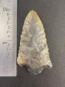
Sold20231920's USA Needlepoint Floral Purse w/ Turquoise ClaspUnited States, ca. early 20th century CE. A lovely needlepoint clutch purse with a wood frame and a gilt-brass clasp inlaid with a massive turquoise stone! The stone setting is on a hinge that hooks oSee Sold Price
Sold2017C.1894 American Folk Animal Needlepoint SamplerUNITED STATES, LATE 19TH CENTURY An American folk art needlepoint sampler. The needlepoint is decorated with various animals, flowers, articles, and the American flag and English Crown. The needlepoinSee Sold Price
Sold20231833 American Needlepoint Embroidery Sampler w/ Poem**Originally Listed At $800** North America, United States, ca. 1833 CE. A framed cotton or linen and silk needlepoint sampler with the alphabet and a virtuous poem, and the name and date: "Martha AnnSee Sold Price
Sold202319th C. American Needlepoint - Bird and Flowers**Originally Listed At $200** United States or Europe, late 19th to early 20th century. An elegant needlepoint set in a custom frame with decorative brass appliques adorning the corners. The theme isSee Sold Price
Sold20231837 American Needlepoint Sampler Beauty of Religion**Originally Listed At $400** North America, United States, ca. 1837 CE. A large cotton needlepoint set in a wooden and glass frame. The handwritten inscription at the top reads "Matilda Nottingham, hSee Sold Price
Sold20241829 American Needlepoint Sampler by Sara Reid**Originally Listed At $400** North America, United States, ca. 1829 CE. A cotton or linen and silk needlepoint sampler with several styles of the alphabet and the name Sarah Reid, with her date of biSee Sold Price
Sold2022Needlepoint Cross Stitched Iowa Framed PieceAnne Feller 1990 needlepoint cross stitched map of Iowa (Bob Fellers home State) in 1920's Arts and Crafts oak frame. Measuring approx. 12.5" tall by 15.25" wide. In good condition with small stain toSee Sold Price
Sold2022Late 19thc United States Military Campaign MapInteresting late 19th Century fold out, miltary campaign map of The United States during The Civil War, Battle of Antietam, by Hugh Rees, Ltd. Plan No. 13. Map pinpoints - West Point, Charleston, NewSee Sold Price
Sold2021HUMOROUS MAP OF US FROM BOSTON POINT OF VIEW"This Map Presents a Bostonian's Idea of the United States of America" by Daniel K. Wallingford, Columbia University Bookstore, New York. Note: NYC does not exist, only Long Island. Circa 1937. UnframSee Sold Price
Sold2023PAN AMERICAN AIRLINES ROUTE MAP. "Fastest way between… USA & Latin America" 1935Title: PAN AMERICAN AIRLINES ROUTE MAP. "Fastest way between… USA & Latin America" 1935 Description: Consult this map for fastest way between all points in the United States and Latin America' bSee Sold Price
Sold2018Map, United States, 1784, first map of the nationMap, United States, 1784,"Carte Des Etats-Unis De L'Amerique Suivant le Traite de Paix de 1783. Dediee et Presentee A.S. Excellence M. Benjamin Franklin Ministre Pleinipotentaire des Etats-Unis", theSee Sold Price
Sold2021Pictorial Map United States IndiansIndians of the U.S.A. Louise E. Jefferson. Friendship Press, New York: 1944. Novelty map showing native American tribes. Vintage color print. 22 1/2" x 34 1/2", overall 26" x 40".See Sold Price
Sold2016John Haven Map: United States and MexicoNew York: Haven & Emmerson, 1846 wood engraved, hand colored map created during the time of the Mexican American War. The map shows the United States and Mexico and includes the Oregon Territory, TexaSee Sold Price
Sold20231819 LIZARS MAP UNITED STATES.W & D Lizars Edinburgh map of the United Sates of America 1819, image 15” x 17,5” framed under glass overall 23” x 25”See Sold Price
Sold201718thc Map: United States of America, Wilkes, 1797Framed antique map, United States of America, Published London 1797 by J. Wilkes. Engraved by Neele, 352 Strand, London. Hand colored, the map shows the United States in the Decade after the AmericanSee Sold Price
Sold2022JOHN TALLIS (1817-1876) AN AMERICAN CIVIL WAR MAP, "United States," LONDON, CIRCA 1863,JOHN TALLIS (1817-1876) AN AMERICAN CIVIL WAR MAP, "United States," LONDON, CIRCA 1863, hand-colored lithograph on wove paper showing, "Federal, Non Slave Holding States (Red); Border, Slaveholding (BSee Sold Price
Sold2021CIVIL WAR-ERA JOHNSON'S MILITARY MAP UNITED STATESFramed engraving with color on paper, "Johnson's New Military Map of the United States, Showing the Forts, Military Posts & c., with Enlarged Plans of Southern Harbors from Authentic Data Obtained atSee Sold Price
Sold20221864 Civil War MAP United States Statistics Commerce1864 Civil War MAP United States Statistics Commerce American Trade Gold Silver The United States Department of Treasury published this Civil War-era report analyzing the commerce of the US GovernmentSee Sold Price
Sold2021Colton Railroad and County Map United States 1878Colton, after G. W., Colton's Railroad and County Map of the United States, The Canadas, &c, 1878, antique map on paper, folded as originally issued, 33 x 42 inches, in a wood frame 36.5 x 47.5 inchesSee Sold Price
Sold2016Antique Map United States Thomson's 1817Antique Map United States Thomson's 1817, authentic antique map, inscribed, "drawn & engraved for Thomson's new general atlas 1817", along with "Northern Provinces of the United States", hand coloredSee Sold Price
1 day LeftEast Coast Fine Arts LLC1777 US Revolutionary War Map French Brion de la Tour Theatre de Guerre$1,000
5 days LeftA.H. Wilkens Auctions & AppraisalsHARPER'S PICTORIAL HISTORY OF THE CIVIL WAR (1866)CA$150
1 day LeftLeonard Auction, a division of The Leonard CompanyEuropean and United States Map Assortment$150
4 days LeftJasper521857-58 Emory Map of Western United States -- Map of the United States and Their Territories Between$220
Jul 13Cain Modern AuctionsDouble Sided U.S. Map by Rand McNally, Illustrated & Equal Area Projection$70
Freeman's | Hindman[MAPS]. A group of 8, incl. 5 maps of North America, one of the western hemisphere, & 2 engravings.$150
6 days LeftSwann Auction Galleries(AMERICAN REVOLUTION--HISTORY.) William Gordon. The History of the Rise, Progress, and Establishment$1,500
Featured4 days LeftJasper52VERY RARE. Map of Washington D.C. Plan for Reclamation of the Marshes, From a Supreme Court Exhibit,$320
Featured4 days LeftJasper52VERY RARE Map of Washington D.C & Georgetown Land Reclamation, From a Supreme Court Exhibit$320
3 days LeftFreeman's | Hindman[Maps & Atlases] A New Map of North America, with the West India Islands...$300


![[MAPS]. A group of 8, incl. 5 maps of North America, one of the western hemisphere, & 2 engravings. (1 of 0)](https://p1.liveauctioneers.com/dist/images/placeholder.jpg?height=282&quality=70)


![[Maps & Atlases] A New Map of North America, with the West India Islands... (1 of 2)](https://p1.liveauctioneers.com/65/332523/179335173_1_x.jpg?height=282&quality=70&version=1717709447)