Sold2016Map, Phelps Map of the United States Traveler's Guide25x21, containing, railroads, steam ships, canals & stage coach routesSee Sold Price
Sold2016Phelps' National Map 1852Heading: Author: Thayer, Horace & Co. Title: Phelps's National Map of the United States, a Travelers Guide. Embracing the Principal Railroads, Canals, Steamboat & Stage Routes Throughout the Union PlSee Sold Price
Sold2022LIONS OF NEW YORK W/ Maps & Engravings, Phelps, N.Y. 1853Rare guidebook to Manhattan, New York, 1853. The Lions of New York: a Guide of Objects of Interest in and around the Great Metropolis. Large folding plate containing views of the Latting Observatory,See Sold Price
Sold2019COLTON'S WESTERN TOURIST EMIGRANT'S GUIDE MAP 1853Western Tourist or Emigrant's Guide, circa 1853, location of Cities, Towns, Post Hamlets, Canals and Stage Roads, Ohio, Michigan, Indiana, Illinois, Missouri, Wisconsin, Iowa, plus a wood engraving scSee Sold Price
Sold20211845 ENSIGN'S TRAVELER'S GUIDE AND MAP OF THE UNITEDSteel-engraved wall map of the United States, published by T. & E. H. Ensign in 1845, depicting the development and settlement of the United States, from the Atlantic, west to the Rio Grande, includinSee Sold Price
Sold20211837 Travelers Guide Ohio Map Canals, Roads, and1837 Travelers Guide Ohio Map Canals, Roads, and Distances Estimate: $300See Sold Price
Sold2021MAP, Eastern US, Phelps & EnsignEastern United States. Phelps & Ensign, Phelps & Ensign's Travellers' Guide, and Map of the United States, Containing the Roads, Distances, Steam Boat and Canal Routes &c., 1842 (dated). Hand Color. TSee Sold Price
Sold20241848 HUGE MAP Illustrated Guide for Travelers AMERICA Cities Travel Guide RARE1848 HUGE MAP Illustrated Guide for Travelers AMERICA Cities Travel Guide RARE J Calvin Smiths “New Guide for Travelers” is a rare 19th-century travel guide with descriptions of numerous AmeriSee Sold Price
Sold20231853 Colton Map of the US Midwest -- Guide through Ohio, Michigan, Indiana, Illinois, Missouri,Title: 1853 Colton Map of the US Midwest -- Guide through Ohio, Michigan, Indiana, Illinois, Missouri, Wisconsin & Iowa. Showing the Township Lines of the United States Surveys … Cartographer: JSee Sold Price
Sold2022Brand new traveler's guide in Italy. Enriched with various partial itineraries maps and 15Milan, Ferdinando Artaria, s.d [1845]. In 8th. Heads with city views, 15 topographical maps of the main cities, 10 maps of itineraries and a map of Italy at the end, slight scattered blooms, small teaSee Sold Price
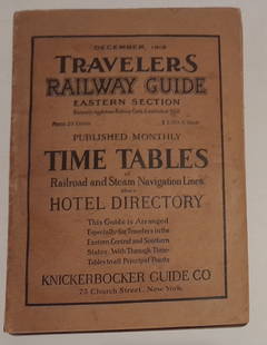
Sold20241915 Traveler's Guide Eastern US. A 344 page bookA 5 3/4" by 8" soft cover book with railroad timetables and other travel information: hotel ads, city, state maps, etc. Paper is supple and not pulpy.See Sold Price
Sold2018Phelps' Traveller's Guide Through the United States. NYPhelps' Traveller's Guide Through the United States. NY 1849. 12mo. 70 p. Lacks map. Ornately gilt front cover featuring steamship vignettes and border vines. // Isaac Taylor. Scenes in America. LondoSee Sold Price
Sold2018With State Seals /Presidents Surrounding U.S. MapAtwood, J. M. (1818-c. 1880) & Phelps, Humphrey (fl. c. 1830-1860). Phelps's National Map of the United States, a Travellers Guide... Engraved map. Ensign & Thayer, 1851. 20 ½" x 25 ¾" sheet. "ESee Sold Price
Sold2022New York Central Lines No.1 Timetable and Raymond &New York Central Lines No.1 Timetable and Raymond & Whitcomb Tours 1900 Travelers Condensed Guide New York Central Lines timetable is 110 pages and includes a system map, Pullman fares, and more. TablSee Sold Price
Sold2018BAEDEKER'S GUIDE & GUIDE THROUGH EUROPE CIRCA 1900Four antique travel guides complete with maps: Baedeker, Karl. Paris and Its Environs, with Routes from London to Paris, Handbook for Travelers: with 14 Maps and 42 Plans. 18th ed., Karl Baedeker, 191See Sold Price
Sold2016Map of Washington, DC, 1853Original engraving from Illustated Gazetter of the US, published by Phelps, Fanning and Company, 1853. Dimensions: 10” x 13 1/2” No Reserve This item ships from Ocean View, DE.See Sold Price
Sold20221847 Phelpss National Map of the United States..Historic Maps 1847 Map "Phelps's National Map of the United States..." 1847-Dated, "Phelps's National Map of the United States, A Traveller's Guide...", Hand-Colored Folding Map of the United States,See Sold Price
Sold20191772 Gentleman’s Guide to France British Travel Voyages1772 Gentleman’s Guide to France British Travel Voyages England MAP Finance RARE ‘The Gentleman’s Guide in His Tour Through France’ is a rare 18th-century guidebook for a traveler going from LSee Sold Price
Sold20232 Travel Maps of US: Atwood Pocket Map 1851 & Williams Framed, 18541st item: PHELPS'S NATIONAL MAP OF THE UNITED STATES, TRAVELLERS GUIDE. EMBRACING THE PRINCIPAL RAIL ROADS, CANALS, STEAM BOAT & STAGE ROUTES THROUGHOUT THE UNION, by J. M. Atwood, published by ThayerSee Sold Price
Sold2019Phelps's National Map of the United States, aReserve Reduced! Title: Phelps's National Map of the United States, a Travellers Guide. ... Publication Date: 1847 Cartographer: ATWOOD, J.M./H. PHELPS Publisher: PHELPS, ENSIGNS & THAYER Size (inchesSee Sold Price
Sold2017Phelps: Antique Pre-Civil War Map of United States 1848Patriotic Antique Pre-Civil War US Map; "Phelps's National Map of the United States, A Travellers Guide. Embracing the principal Rail Roads, Canals, Steam Boat & Stage Routes, Throughout the Union.".See Sold Price
Sold20211876 MAPS Traveler’s Handbook in Europe Geography1876 MAPS Traveler’s Handbook in Europe Geography Fetridge Great Britain Russia “Harper’s Hand-book for Travellers in Europe” is a 19th-century travel guide for those touring European countrieSee Sold Price
Sold20231855 Guide for the Pennsylvania Railroad with an Extensive Map from the Pennsylvania RailroadA 40 page Guide for the Pennsylvania Railroad with an Extensive Map; Including the Entire Route, with all its Windings, Objects of Interest, and Information Useful to the Traveler. Philadelphia: T.K.See Sold Price
Sold2023[GUIDE BOOKS] NIAGARA FALLS. 1853THE ONTARIO AND ST. LAWRENCE STEAMBOAT COMPANY'S HAND-BOOK FOR TRAVELLERS TO NIAGARA FALLS, MONTREAL AND QUEBEC, AND THROUGH LAKE CHAMPLAIN TO SARATOGA SPRINGS. Illustrated with maps and engravings. BSee Sold Price
May 10Rail & Road AuctionsFour 1992 Russell's Official Bus Guides and Motor Coach Guide Map Supplements$20
2 hrs LeftClaydon Auctioneers LtdMaps: A 20thC Map of England and Wales on two folding cloth sheets North Sheet and South Sheet, with£16
May 10Rail & Road AuctionsThree American Aviation Publications - 1953 and 1956 Official Airline Guides and 1948 Air Traffic$30
May 12Schilb Antiquarian Rare Books1883 FLORIDA for Tourists & Settlers Illustrated Fort Barrancas MAP Fine BINDING$78(5 bids)
May 10Rail & Road AuctionsSeven Panama Pacific Line Steamship Travel Guides, Timetable, and Menu - 1927 to 1939$30
May 10Rail & Road AuctionsPair of American Aviation Official Airline Guides - October 1957 and March 1965$20
3 days LeftRapid Estate Liquidators and Auction GalleryDisney Art Prints and Old Epcot Discovery Guide$30


![Brand new traveler's guide in Italy. Enriched with various partial itineraries maps and 15: Milan, Ferdinando Artaria, s.d [1845]. In 8th. Heads with city views, 15 topographical maps of the main cities, 10 maps of itineraries and a map of Italy at the end, slight scattered blooms, small tea](https://p1.liveauctioneers.com/3796/250546/130126120_1_x.jpg?height=310&quality=70&version=1654521704)


![[GUIDE BOOKS] NIAGARA FALLS. 1853: THE ONTARIO AND ST. LAWRENCE STEAMBOAT COMPANY'S HAND-BOOK FOR TRAVELLERS TO NIAGARA FALLS, MONTREAL AND QUEBEC, AND THROUGH LAKE CHAMPLAIN TO SARATOGA SPRINGS. Illustrated with maps and engravings. B](https://p1.liveauctioneers.com/8124/283183/149424745_1_x.jpg?height=310&quality=70&version=1679790999)


