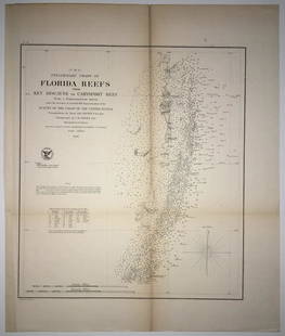
Sold2020(F No.4) Preliminary Chart of Florida Reefs from KeyTitle/Content of Map: (F No.4) Preliminary Chart of Florida Reefs from Key Biscayne to Carysfort Reef... Publication Date: 1855 Cartographer: Totten, Jas./I. Hull Adams Publisher: U.S. Coast Survey DeSee Sold Price
Sold2023U S Coast Survey 1856 Large Map. St. Mary's Bar & Fernandina Harbor Florida"Preliminary Chart of St. Mary's Bar and Fernandina Harbor Florida"Large Lithograph Map Published 1857, Washington for "U.S. Coast and Geodetic Survey" Folds as issued. Paper Size: 25 x 23 inch (64 xSee Sold Price
Sold2020United States – Florida Reefs British Admiralty ChartSmall scale and detailed sea chart of the Florida Reefs with Key West and the former rail road over the islands. Tidal information is mentioned for the most important ports. Authentic, very detailed sSee Sold Price
Sold2023DOC Map, Fowey Rocks to Alligator Reef, Florida East CoastA color map depicting the land and sea area of Fowey Rocks to Alligator Reef. Publishing stamp by "The U.S Coast and Geodetic Survey" located on bottom. Issued: 1921 Dimensions: 46"L x 35"W MaSee Sold Price
Sold2018Preliminary Chart of St. Augustine Harbor FloridaMap: Preliminary Chart of St. Augustine Harbor Florida Publication Date: 1862 Publisher: U.S. C.S. Size (inches): 20.25X21.25 Attractive detailed chart with soundings and sailing directions. Shows towSee Sold Price
Sold2020Preliminary Chart of St. Augustine Harbor FloridaTitle/Content of Map: Preliminary Chart of St. Augustine Harbor Florida Cartographer: F. W. Dorr Date: 1879 Publisher: U.S. C.S. Size: 21”Height - 21.75”Width Railroad ends at west bank ofSee Sold Price
Sold2020United States, East Coast – Forida Street BritishUnused, very detailed sea chart of the Florida coasts with Miami, Cape Kennedy, the Bahama Banks and so on. The first surveys are from 1898 from Admiralty surveys. Authentic, very detailed sea chart,See Sold Price
Sold2023USC&GS Map, Alligator Reef to Sombrero Key, FL Gulf CoastTitle "USC&GS Map, Alligator Reef to Sombrero Key, Florida Gulf Coast". A color map depicting the land and sea area of Alligator Reef to the Sombrero Key. Publishing stamp by "The U.S Coast and GeodetSee Sold Price
Sold2018Scarce Sea Chart with every building, fort andHarrison, A. M. & Dorr, F. W. et al. Coast Chart No. 59, St. Augustine Inlet to Halifax River Florida. Lithographed map. U.S. Coast and Geodetic Survey, c. 1885. 41 ¼" x 31 ⅛" sheet. Great dSee Sold Price
Sold2023ANTIQUE FLORIDA FRAMED MAPS - LOT OF 2148268 ANTIQUE FLORIDA FRAMED MAPS - LOT OF 2 Antique Florida map framed map to include one 1853 U.S. Coast Survey Chart or Map of St. George's Sound, Florida, and one unsigned map of Florida denotedSee Sold Price
Sold2019A.D. Bache U.S. Coast Survey Charts East CoastA.D. Bache: Preliminary Coastal Chart N. 8, Sequin Island to Kennebunkport, Maine 1859. Measures 38” X 22”. Paper size 40" x 24 1/2". Used Condition, creases, burn. electrotype have some sSee Sold Price
Sold2018U.S Coast Survey 1853 Map. Gargathy Machipongo Inlet VA"Preliminary Chart of the Sea Coast of Virginia From Gagathy Inlet to Gr. Machipongo Inlet" Electrotype Map Published 1843-65, Washington for "Report of the Superintendent of the U.S. Coast Survey..."See Sold Price
Sold2020Nautical Map / Sea Chart, #1212 Eastern Long IslandDescription: Nautical Map / Sea Chart, United States East Coast, Connecticut - New York, Long Island Sound, Eastern Part, 12th edition feb 10 / 69 ; all measurements are approximate; Folded; ShippingSee Sold Price
Sold2021Nautical Map / Sea Chart, #362 Block Island Sound andDescription: Nautical Map / Sea Chart, United States East Coast, New York, Long Island, Block Island Sound and Gardiner's Bay, 6th edition, Feb 10/69; Shipping: $20; different rate to California, AlasSee Sold Price
Sold2018Antique 1856 US Coastal Survey of Martha's VineyardTitle/Content of Map: 1856 US Coastal Survey of Martha's Vineyard amd Nantucket Area in Massachusetts -- Preliminary Chart of Part of the Sea Coast of Massachusetts from Saughkonnet River to PlymouthSee Sold Price
Sold20201858 US Coast Survey Map of Charleston Harbor --Title/Content of Map: 1858 US Coast Survey Map of Charleston Harbor -- Preliminary Chart of Charleston Harbor and Its Approaches from a Trigonometrical Survey Under the Direction of A.D. Bache… CartSee Sold Price
Sold2021Antique Coast Survey Map of the Atchafalaya BayAntique Coast Survey Map of the Atchafalaya Bay , "Preliminary Chart of Atchafalaya Bay Louisiana... A.D. Bache, Superintendant", 1858, lithograph, with later hand-coloring, sight 24 1/2 in. x 31 1/4See Sold Price
Sold2024Fusan (Busan) harbour, South Korea. ADMIRALTY sea chart 1912 (1955) old mapCAPTION PRINTED BELOW PICTURE: 'Korea - South East Coast - Fusan Harbour' DATE PRINTED: Surveyed to 1913. Published 1912. New edition 1914. Corrections to 1955 IMAGE SIZE: Approx 102.5 x 69.5cm, 40.25See Sold Price
Sold2021Preliminary Chart of Nantucket Shoals"Preliminary Chart of Nantucket Shoals", from a trigonometrical survey under the direction of A.D. Bache Superintendent of the Survey of the coast of the United States, 1864 23.5 in. x 19.5 in. FramedSee Sold Price
Sold2021(D No. 3) Preliminary chart of the Entrances to CapePublication Date: 1854 Title: (D No. 3) Preliminary chart of the Entrances to Cape Fear River and New Inlet North Carolina Cartographer: C.P. Bolles Publisher: U.S. Coast Survey / Robert Armstrong HeiSee Sold Price
Sold2021(D. No.3) Preliminary Chart of lower part of Cape FearPublication Date: 1855 Title: (D. No.3) Preliminary Chart of lower part of Cape Fear River North Carolina Cartographer: C.P. Bolles Publisher: U.S. Coast Survey Height: 30.5 Width: 25.5 From a trigonoSee Sold Price
Sold2020(Sketch F, No.5) Preliminary Chart of Key West HarborTitle/Content of Map: (Sketch F, No.5) Preliminary Chart of Key West Harbor and Approaches... 1851 Publication Date: 1851 Cartographer: KNORR, E. K./ISSAC HULL ADAMS Publisher: U.S. COAST SURVEY DescrSee Sold Price
Sold2018U.S Coast Survey 1853 Map. Ship Island Shoal, Louisiana"Preliminary Chart of Ship Island Shoal Louisiana" Electrotype Map Published 1843-65, Washington for "Report of the Superintendent of the U.S. Coast Survey..." Published under the supervision and direSee Sold Price
Sold2018U.S. Coast Survey 1853 Map of St. Georges Sound,"Preliminary Reconnaissance of the Middle or Main, and West Entrances to St. Georges Sound Florida" Electrotype Map Published 1843-65, Washington for "Report of the Superintendent of the U.S. Coast SuSee Sold Price
2 days LeftJasper52Kingston approach Jamaica south coast Caribbean ADMIRALTY chart 1962 (1966) map$120
2 days LeftJasper52Venezuela Coast Trinidad Tobago Isla Margarita ADMIRALTY chart 1894 (1950) map$120
2 days LeftJasper52Central America Caribbean Gulf of Mexico chart Ports lighthouses LARGE 1918 map$45
Featured2 days LeftJasper52Kingston Harbour Port Royal Jamaica Caribbean ADMIRALTY chart 1960 (1966) map$140
4 days LeftJM Hobby Supply and Railroad Artifact AuctionsFlorida East Coast RY Rococo Pattern Dinner Plate$30(2 bids)
3 days LeftRail & Road AuctionsEleven Railroad China Butter Pats - Fred Harvey, John H. Murphy, Seaboard Air Line, Florida East$40
2 days LeftRail & Road AuctionsMixed Group of Southeastern Railroad Items - Switch Key, Locks, Lantern Globe, Timetables, and More$30
6 days LeftCalifornia Historical DesignFrank Lloyd Wright "Buildings Plans and Designs" Portfolio of 100 Numbered Plates 1963$800
6 days LeftGOLDEN SUN AUCTIONS, Inc. (formerly Appraisal & Estate Sale Specialists, Inc.)(9) 1997-99 Mattel Hot Wheels Multi Pack Assortment-NOS$80(4 bids)
11 hrs LeftFreeman's | Hindman[Maps & Atlases] A New Map of North America, with the West India Islands...$300
6 days LeftGOLDEN SUN AUCTIONS, Inc. (formerly Appraisal & Estate Sale Specialists, Inc.)(14) 1998 Mattel Hot Wheels, Black Box Collectible-MIB-NOS$50(2 bids)
6 days LeftGOLDEN SUN AUCTIONS, Inc. (formerly Appraisal & Estate Sale Specialists, Inc.)(14) 1998 Mattel Hot Wheels, Black Box Collectible-MIB-NOS$60(2 bids)


![[Maps & Atlases] A New Map of North America, with the West India Islands... (1 of 2)](https://p1.liveauctioneers.com/65/332523/179335173_1_x.jpg?height=282&quality=70&version=1717709447)


