Sold2018Western Hemisphere by Reinecke *RARE*Title/Content of Map: Western Hemisphere by Reinecke *RARE* Date: 1804 Cartographer: J.C. M. Reinecke Material/Medium: Paper Size: 27" x 23" Provenance: New York Rare hand colored engraved Map. PleaseSee Sold Price
Sold2022Western Hemisphere. RARE Swedish issue by A. Akerman 1768-1774Title: Western Hemisphere. RARE Swedish issue by A. Akerman 1768-1774 Date/Period: 1768-1774 Materials: Copperplate engraved Size: 7 1/2 x 6” A very hard to obtain map of the new world. 1768-1774. BSee Sold Price
Sold2021PAIR NC WYETH NAT GEO 1928 MAPSTwo Rare National Geographic Eastern and Western Hemispheres Chromolithographic Maps by NC Wyeth (1822-1945). Washington, DC, 1928. Each: 16 3/4 x 18 1/2 inches sheet. Fold lines visible, as is frequeSee Sold Price
Sold20181779 History of America Robertson Columbus Cortez1779 History of America Robertson Columbus Cortez Magellan Mexico MAP Italian 4v “A historical classic! The first successful attempt to write a scholarly history of the Western Hemisphere.” (GSee Sold Price
Sold20201851 History of America Robertson Voyages Columbus1851 History of America Robertson Voyages Columbus Cortez Magellan Mexico French “A historical classic! The first successful attempt to write a scholarly history of the Western Hemisphere.” (GriffSee Sold Price
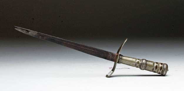
Sold2015Rare 18th C. Colonial Iron Dagger, ex-HistoriaWestern Hemisphere, probably east coast US, ca. 18th century CE. Long and deadly iron dagger inserted into a decorated white metal handle with angled crossguard decorated with incised leaf pattern. SiSee Sold Price
Sold2017Clouet: Antique Map of the Western Hemisphere, 1781Title/Content of Map: Carte D'Amerique Date Printed: 1781 Cartographer: Clouet Material/Medium: Paper Size: 20" x 26" Rare and highly decorative 'Bay of the West' Map of the Western Hemisphere. PublisSee Sold Price
Sold2023Thomson, John (Pub) 1825 Map. Western Hemisphere (Faults)Copper Engraved Map Published 1825 by John Thomson, Edinburgh for "The Edinburgh School Atlas" by N. R. Hewitt. Maps Engraved by Hewitt. Original Outline Hand Colour. Rare. Paper Size: 10.5 x 8 inch (See Sold Price
Sold2021MAP, Western Hemisphere, BlaeuBlaeu's Stunning Carte-a-Figures Map of the Americas in Full Contemporary Color. Western Hemisphere - America. Willem Blaeu, Americae Nova Tabula, 1642 (circa). Hand Color. This stunning carte-a-figurSee Sold Price
Sold2017Hondius: Antique Map of the Western Hemisphere, 1631Title: America noviter delineata. Hondius 1631 western hemisphere with polar inserts Map maker: Henricus Hondius Place and Year: Amsterdam, 1631 Dimensions: 37.7 x 49.8 cm (14¾ x 19½ in) Technique:See Sold Price
Sold20221746 MAP OF THE WESTERN HEMISPHERE By HomannHistoric Maps 1746 MAP of the WESTERN HEMISPHERE by Homann with Cartouche at lower left depicts Native American Indians 1746-Dated, Hand-Colored Engraved MAP OF THE WESTERN HEMISPHERE titled, "AmericaSee Sold Price
Sold20231729 Western Hemisphere with California as a island. By Philipp CluverTitle: 1729 Western Hemisphere with California as a island. By Philipp Cluver Date/Period: 1729 Materials: Copperplate engraved, hand colored Size: 10 1/2 x 8 1/4” Western Hemisphere with CalifoSee Sold Price
Sold2017Hondius: Antique Map of the Western Hemisphere, 1630Title/Content of Map: Western Hemisphere by H Hondius with sea monsters Date Printed: c1630-1634 Cartographer: Henricus Hondius Material/Medium: Paper Size: Approx 17" x 21" Magnificent Map. PublishedSee Sold Price
Sold2020Untitled [Western Hemisphere]Title: Untitled [Western Hemisphere] Prublication Date: 1821 Cartographer: Brue, A.H. Publisher: Charles Simonneau Size: 36.25Height - 36.25Width Additional Information: Very scarce folding wall sizeSee Sold Price
Sold2021Homann 1710-1724 Map of Western HemisphereDESCRIPTION: This map incorrectly depicts California as its own island separated from America, as other mapmakers often mistakenly did in cartography. Large title cartouche depicting indigenous peopleSee Sold Price
Sold20221806-Dated LAmerique Western Hemisphere MapHistoric Maps 1806 Western Hemisphere Map "L'Amerique divifee Pars Grands Etats Janvier C.F. Delamarche, Robert deVaugondy" 1806-Dated Hand-Colored Engraved Copper Plate Map of the Western HemisphereSee Sold Price
Sold2022A large hand colored map of the Western hemisphere by Jean-Baptiste Louis ClouetA large hand colored map of the Western hemisphere by Jean-Baptiste Louis Clouet, printed on heavy laid paper and titled Carte D'Amerique divisee en ses principaux Pays, Dressee sur les Memoires les pSee Sold Price
Sold2022Denoyer-Geppert Series. Western HemisphereTitle: Denoyer-Geppert Series. Western Hemisphere Cartographer: L. PHILIP DENOYER Publisher: DENOYER-GEPPERT CO. Height: 53.5 Width: 42 Schoolroom map on spring roller. Shows some nautical distances.See Sold Price
Sold2020WYETH, N.C. Map of Discovery - Western HemisphereWYETH, N.C. "Map of Discovery - Western Hemisphere." Fifth of the series of five mural by N.C. Wyeth, the originals which adorn the walls of the National Geographic Society buildings.Washington: NatioSee Sold Price
Sold2017Thomson: Antique Map of the Western Hemisphere, 1817Title/Content of Map: 'Western hemisphere' North & South America. Polynesia. Date Printed: 1817 Image Size: Approx 55.0 x 52.5cm, 21.5 x 20.75 inches (Large); Please note that this is a folding map. TSee Sold Price
Sold2020Beradley's Atlas of the Western Hemisphere 1887Bradley's Atlas of the Western Hemisphere, 1887, Wm H Bradley & Bro. Has some damage to the cover and what appears to be water damage on the cover as well. The front cover is slightly loose but the paSee Sold Price
Sold2022WESTERN HEMISPHERE HAND DRAWN MAPFine 19th century hand drawn pen and ink map of the Western Hemisphere with North and South Poles and floral embellished margins. 13.5 x 12.5 inches, framed 19 x15. VG condition.See Sold Price
Sold2022Western Hemisphere with celestial movements, 1780/81 scarce map by J. B. NolinTitle: Western Hemisphere with celestial movements, 1780/81 scarce map by J. B. Nolin Date/Period: 1780/1781 Materials: Hand colored copper plate engraved Size: 14 1/2 x 10 1/4” A fascinating map thSee Sold Price
Sold2019WESTERN HEMISPHERE. Shows Russian America, GranTITLE/CONTENT OF MAP: 'Western Hemisphere' Alaska is indicated as "Russian America" as it was prior to its sale to the United States in 1867. The border between British North America (now Canada) andSee Sold Price
Jun 02Schilb Antiquarian Rare Books1850 Colton Voyages California San Francisco Brazil Slave Trade Peru Deck & Port$1
Jun 02Schilb Antiquarian Rare Books1863 Emancipation of SLAVERY in America CIVIL WAR French Colonies Cochin RARE$1
May 12Schilb Antiquarian Rare Books1890 CUSTER 1st ed Following the Guidon Civil War Indian Wars Little Big Horn$170(5 bids)
May 12Schilb Antiquarian Rare Books1853 INDIANS Legends Traditions Native American Folklore Language SCHOOLCRAFT$115(2 bids)
May 12Schilb Antiquarian Rare Books1861 William Wilberforce Enormity of SLAVE TRADE Abolition Bill America RARE$40(3 bids)
Jun 02Schilb Antiquarian Rare Books1880 BIBLE Gallery Gustave Dore ART Illustrated Old/New Testament Bible Scenes$1
Jun 02Schilb Antiquarian Rare Books1909 Rubaiyat Omar Khayyam Philosophy Persia Mysticism Willy Pogany Illustrated$1
7 days LeftHunt and Peck Estate Services, Inc.Jacques Nicolas Bellin Map Of Western Part Of New France Or Canada$200(1 bid)
May 12Neo FineArts Inc1995 Uncut Sheet of 32 Federal Reserve $2 Dollar Currency Notes, Rare UNC, Real Money$110(3 bids)
May 12Neo FineArts IncAn Exquisite and Rare Vintage Chinese Handcrafted Peking Glass Lucky Ball with Dragon & Phoenix$40
7 days LeftHunt and Peck Estate Services, Inc.1849 Alex Mackay 1st US Ed. 2 Vol. "The Western World or Travels in the United States in 1846-1847"$50
2 days LeftOAB AuctionsJoseph Stella Authentic Original Painting Landscape Mountain Pastel Artwork Rare$200


![Untitled [Western Hemisphere]: Title: Untitled [Western Hemisphere] Prublication Date: 1821 Cartographer: Brue, A.H. Publisher: Charles Simonneau Size: 36.25Height - 36.25Width Additional Information: Very scarce folding wall size](https://p1.liveauctioneers.com/5584/164887/83261185_1_x.jpg?height=310&quality=70&version=1585745966)


![Western Album w/ Lincoln & Rare Views [Kansas] (1 of 2)](https://p1.liveauctioneers.com/7226/322253/173251612_1_x.jpg?height=282&quality=70&version=1710004847)


