Sold2019George Cram’s "Rail Road Map, Texas and IndianGeorge Cram’s "Rail Road Map, Texas and Indian Territory," 1900, H.- 18 3/8 in., W.- 26 3/4 in.See Sold Price
Sold20212 Large Scrapbooks of Shell Oil 30's US Road Map BooksPair of Folio Style Shell Oil 1930s US Road Map Books. These map booklets, with tabs for various US States like North Carolina, South Carolina, Virginia, West Virginia, and Texas, were published by ShSee Sold Price
Sold2023Box of Assorted Maps [147388]Box of approx 120 maps,1960's to 1970's? Folding road maps of the West, Big Bend National Park, Missouri, Texas, Wyoming, Colorado, Yellowstone, S. Dakota, Colorado Parks and more.See Sold Price
Sold2022Asher & Adams' unique RR map of Texas, 1871County map of East Texas depicted in the unique Asher & Adams’ style, without roads to highlight the presence of railroads. Extends from Louisiana west to beyond San Antonio and features the raSee Sold Price
Sold2021Map of the Southern States - American Civil WarTitle: Map of the Southern States, Including Rail Roads, County Towns, State Capitals, County Roads, the Southern Coast from Delaware to Texas, Showing the Harbors, Inlets, Forts and Position of BlocSee Sold Price
Sold2023Harper & Brothers, Map of the Southern States, Including Rail Roads, County Towns, State Capitals,Title: Map of the Southern States, Including Rail Roads, County Towns, State Capitals, County Roads, the Southern Coast from Delaware to Texas, Showing the Harbors, Inlets, Forts and Position of BlocSee Sold Price
Sold2024Keith Haring Artwork Signed on a Shell Oil New York Road Map 18 in. x 24 in.Keith Haring Artwork Signed on a Shell Oil New York Road Map 18 in. x 24 in. size: 18 x 42 open - rippingSee Sold Price
Sold2022HUSKY GASOLINE SERVICE STATION MAP DISPLAY W/ HUSKY ROAD MAPS.SST. An excellent and complete example of this Circa 1950's Service Station Road Map Display from Husky showing a Tin Husky Sign at the face and complete with Maps. CONDITION: Display is in overall exSee Sold Price
Sold2022New road map of the city of Paris 1839 Rosselin editeur engravingNouveau plan routier de la ville de Paris, Guide exacte de cette capitale : en 12 arrondissemens avec leurs mairies et en 48 quartiers, 1839V. ROSSELIN (19th century), print editor, Paris, EstablishedSee Sold Price
Sold2022British road maps.- Ogilby (John) The Roads fromNO RESERVE British road maps.- Ogilby (John) The Roads from Chelmsford in Essex to St. Edmonds-Bury in Suffolk & Saffron-Walden in Essex, strip road map, engraving with hand-colouring, on thin laid paSee Sold Price
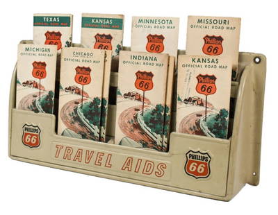
Sold2023Vintage Phillips 66 Road Map Embossed Display RackVintage Phillips 66 embossed plastic road map display rack full with original 1930s Phillips 66 maps. Rack has discoloration, some expected chips/ cracks, and wear from use and age. Displays well withSee Sold Price
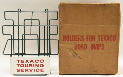
Sold2021Vintage NOS Texaco Road Map Metal Display RackVintage new old stock Texaco road map metal display rack in original box. Nice condition with light wear from age and storage. Display rack measures approximately 10-1/2" tall by 9" across.See Sold Price
Sold2020Road map of Southern California 1918Heading: (California) Author: Title: Automobile Road Map of Los Angeles, Orange, Riverside and San Bernardino Counties Place Published: Los Angeles Publisher:Security Trust & Savings Bank Date PSee Sold Price
Sold2018Auto road map of greater Los Angeles, 1916Heading: (California - Southern) Author: Parker, O.K. Title: Automobile Road Map of Los Angeles, Orange, Riverside and San Bernardino Counties Place Published: Los Angeles Publisher:Security Trust & SSee Sold Price
Sold20221895 Hudson River NY - Harper & Bros Bicycle Road Map1895 Harper & Brothers advertising bicycle map. Route travels along the Hudson River, from below 181st Street to Sleepy Hollow just above Tarrytown New York. Bicycle Road Maps in Harper's Round TableSee Sold Price
Sold2019AN VINTAGE MAP, "Texas and Indian Territory," SECONDAN VINTAGE MAP, "Texas and Indian Territory," SECOND QUARTER 20TH CENTURY, color engraving on paper, showing counties, cities, rail lines, and rivers. 13.25" x 10.125"See Sold Price
Sold2024Two Philadelphia City Road MapsTwo Philadelphia City Road Maps Sidney Hall, "Philadelphia" scale map engraving published Chapman and Hall 1840 14" x 17" along with "Philadelphia" circa 1850 or later map frame size 18 7/8" x 22 1/2"See Sold Price
Sold2021Colton's Road Map of the Counties of Orange andPublication Date: 1896 Title: Colton's Road Map of the Counties of Orange and Rockland Cartographer: G.W. & C.B. Colton & Co. Publisher: G.W. & C.B. Colton & Co. Height: 22.75 Width: 26.25 State of NeSee Sold Price
Sold2022Gulf Tourgide Service road map display with maps & clipboard9" x 18" x 5"d Gulf road map display with maps & Gulf clipboard showing normal wear. *PLEASE NOTE, THERE IS ONLY ONE WAY TO PAY FOR ONLINE ITEMS IN THIS AUCTION WHICH IS THROUGH LIVE AUCTIONEERS. THISSee Sold Price
Sold2021Road map from Mono Lake to Reno 1938Heading: (California & Nevada) Author: Title: Mono Lake to Reno Place Published: San Francisco Publisher:California State Automobile Association Date Published: [c.1938] Description: <See Sold Price
Sold2020MOBIL GASOLINE SERVICE STATION TIN ROAD MAPS DISPLAY W/SST. A very nice example of this Tin Service Station Road Map Display from Mobil Gasoline. Tin is in very good condition, showing only minimal age wear and minor areas of paint loss in the corners. ThSee Sold Price
Sold2020Rare road map from Bridgeport to Reno & TahoeHeading: (California) Author: Title: Mono Lake & Bridgeport to Lake Tahoe & Reno Place Published: Los Angeles Publisher:Automobile Club of Southern California Date Published: 1937 DescSee Sold Price
Sold20221675 Ogilby Road Map from London to Flambourough HeadTitle: 1675 Ogilby Road Map from London to Flambourough Head -- The Road from London to Flambourough Head in Com Ebor… Cartographer: J Ogilby Year / Place: 1675, London Map Dimension (in.): 13.4 X 1See Sold Price
5 days LeftRail & Road AuctionsMixed Group of Twelve Airline Timetables - Frontier, Eastern, Southern, Texas International, and$20
5 days LeftRail & Road AuctionsEleven Army Corps of Engineers Port Series No. 1 Through No. 8 Books with Fold Out Maps$35(2 bids)
5 days LeftRail & Road AuctionsEleven Port Series Books with Fold Out Maps - No. 9 Through No. 23 - Army Corps of Engineers$20(1 bid)
May 17Albion AuctionsPaterson & Mogg C1830 British Road Map. Isle of Thanet and Adjacent Country$5(1 bid)
May 17Albion AuctionsPaterson & Mogg C1830 British Road Map. New Shorehamd to Chichester to Fareham$5(1 bid)
May 17Albion AuctionsPaterson & Mogg C1830 British Road Map. Banks of the River Wye. Chepstow etc$5(1 bid)


![Box of Assorted Maps [147388]: Box of approx 120 maps,1960's to 1970's? Folding road maps of the West, Big Bend National Park, Missouri, Texas, Wyoming, Colorado, Yellowstone, S. Dakota, Colorado Parks and more.](https://p1.liveauctioneers.com/2699/299063/159201775_1_x.jpg?height=310&quality=70&version=1692045182)


![Road map from Mono Lake to Reno 1938: Heading: (California & Nevada) Author: Title: Mono Lake to Reno Place Published: San Francisco Publisher:California State Automobile Association Date Published: [c.1938] Description: <](https://p1.liveauctioneers.com/642/218849/112379266_1_x.jpg?height=310&quality=70&version=1631923877)


