Sold2022Asher & Adams' unique RR map of Texas, 1871County map of East Texas depicted in the unique Asher & Adams’ style, without roads to highlight the presence of railroads. Extends from Louisiana west to beyond San Antonio and features the raSee Sold Price
Sold2022Scarce Asher & Adams RR map of Florida, 1874Beautiful and scarce hand colored map of Florida done in the unique Asher & Adams style. All railroad lines—both existing and proposed—shown. Large 2-page map. Asher & Adams produced oneSee Sold Price
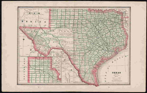
Sold20181872 Asher and Adams Map of Eastern Texas -- Asher &Reserve Reduced! Title/Content of Map: 1872 Asher and Adams Map of Eastern Texas -- Asher & Adams' Texas Date: 1872 New York Cartographer: Asher & Adams Size: 22.2 X 15.8 in. A very nice, large map ofSee Sold Price
Sold2022Scarce Texas map (eastern part) from Asher & Adams,County map of Eastern Texas extends from Louisiana west to beyond San Antonio and features the railroad system of that time. Features numerous railroads still in their infancy, along with proposed futSee Sold Price
Sold2022Scarce Texas map (western part) from Asher & AdamsLarge double-page map of Western Portion of Texas with inset of extreme western tip of the state. Shows towns, proposed railroad lines and river, including the Colorado River and the Rio Grande. The fSee Sold Price
Sold2018Asher & Adams: Antique Map of Indian Territory, 1874Title/Content of Map: 1874 Asher & Adams Indian Territory Map -- Asher & Adams Indian Territory and Texas North West Portion Date Printed: 1874, New York Cartographer: Asher & Adams Size: 16.3 x 23.2See Sold Price
Sold2017Asher & Adams: Map of Indian Territory, 1874Map: Hand Colored Map of Indian Terratory Maker: Asher & Adams Date: 1874 Size: Approx. 16x22 inches First edition of this large format railroad map of IndianTerritory, from Asher & Adams' Atlas of thSee Sold Price
Sold20191872 Asher & Adams Map of Minnesota -- Asher & Adams'Title/Content of Map: 1872 Asher & Adams Map of Minnesota -- Asher & Adams' Minnesota Date: 1872, New York Cartographer: Asher & Adams Size: 22.4 x 16.1 in. This is a fantastic, very large double pageSee Sold Price
Sold2017Asher & Adams: Map of Pennsylvania & New Jersey, 1872Nicely colored Asher & Adams Pennsylvania and New Jersey. 1872. 15.75 x 22.75. Striking example of an Asher & Adams map which are often pale in hand coloring, or somewhat brittle. This one is nicely cSee Sold Price
Sold20181872 Asher & Adams Map of Michigan -- Asher & Adams'Title/Content of Map: 1872 Asher & Adams Map of Michigan -- Asher & Adams' Michigan Date: 1872, New York Cartographer: Asher & Adams Size: 22.2 x 16 in. This is a fantastic, very large double page mapSee Sold Price
Sold20181872 Asher & Adams Map of Europe -- Asher and Adams'Title/Content of Map: 1872 Asher & Adams Map of Europe -- Asher and Adams' Europe Date: 1872, New York Cartographer: Asher & Adams Size: 16 X 23 in. An attractive map of Europe showing rivers, lakes,See Sold Price
Sold20162 19th Century MapsDESCRIPTION: Two 19th century maps. Includes: 1) Asher & Adams map of Florida with colored counties. Tears, abrasions, toning, spotting, split and hinged on reverse. Sealed under plastic against a foaSee Sold Price
Sold2023Highly collectible 1860 RR map of Texas, S. A. Mitchell, Jr.One of the most attractive atlas maps of Texas to appear in the mid-19th century. This authentic antique map (160 years old) was published when the Civil War was at its height. It shows the region froSee Sold Price
Sold2022Exceptional 1864 RR map of Texas, S. A. Mitchell, Jr.One of the most attractive atlas maps of Texas to appear in the mid-19th century. This nearly 160-year-old map--published during the height of the Civil War--shows the region from western New Mexico tSee Sold Price
Sold20191872 Asher and Adams Map of Arkansas and Western IndianTitle: 1872 Asher and Adams Map of Arkansas and Western Indian Territory -- Asher & Adams's Arkansas and Portion of Indian Territory Date: 1872 New York Cartographer: Asher & Adams Size: 15.8 x 22.8 iSee Sold Price
Sold20221872 Asher and Adams Map of Florida -- Asher & Adams' FloridaTitle: 1872 Asher and Adams Map of Florida -- Asher & Adams' Florida Cartographer: Asher & Adams Year/Place: 1872 New York Dimensions: 15.8 x 22.8 in. Description: This is a superb, large map of FloriSee Sold Price
Sold20181872 Asher and Adams Map of Florida -- Asher & Adams'Title/Content of Map: 1872 Asher and Adams Map of Florida -- Asher & Adams' Florida Date: 1872 New York Cartographer: Asher & Adams Size: 15.8 x 22.8 in. A very nice, large map of Florida. The major cSee Sold Price
Sold2022Clean 1883 RR map of Texas, Geo. F. CramInteresting cerographic map of Texas from Cram’s Unrivaled Family Atlas of the World. Predates subdivision of Tom Green, Pecos, Crockett and Presidio Counties. Shows rail system throughout statSee Sold Price
Sold20191872 Asher and Adams Map of Southern California andTitle/Content of Map: 1872 Asher and Adams Map of Southern California and Nevada -- Asher & Adams' California & Nevada Southern Portion Date: 1872 New YorkCartographer: Asher & Adams Size: 15.8 x 22.8See Sold Price
Sold20191872 Asher and Adams Map of Kansas -- Asher & Adams'Title: 1872 Asher and Adams Map of Kansas -- Asher & Adams' Kansas Date: 1872 New York Cartographer: Asher & Adams Size: 15.8 x 22.8 in. Additional Information: A very nice, large map of Kansas with mSee Sold Price
Sold20181872 Asher and Adams Map of United StatesTitle/Content of Map: 1872 Asher and Adams Map of United States -- Asher & Adams' United States and Territories Date Printed: 1872 New York Cartographer: Asher & Adams Size: 15.8 x 22.8 in. A very nicSee Sold Price
Sold20191872 Asher and Adams Map of Wisconsin -- Asher &Title/Content of Map: 1872 Asher and Adams Map of Wisconsin -- Asher & Adams's Wisconsin Date: 1872 New York Cartographer: Asher & Adams Size: 15.8 x 22.8 in. A very nice, large map of Wisconsin. TheSee Sold Price
Sold20221872 Asher and Adams Map of Illinois -- Asher & Adams's IllinoisTitle: 1872 Asher and Adams Map of Illinois -- Asher & Adams's Illinois Cartographer: Asher & Adams Year / Place: 1872 New York Map Dimension (in.): 22.2 X 15.8 in. A very nice, large map of Illinois.See Sold Price
Sold20191872 Asher and Adams Map of Europe -- Asher & Adams'Title: 1872 Asher and Adams Map of Europe -- Asher & Adams' Europe Date: 1872 New York Cartographer: Asher & Adams Size: 15.8 x 22.8 in. Additional Information: A very nice, large map of Europe. The mSee Sold Price
May 16Potter & Potter AuctionsSTORM, Mark. Official Texas Brags Map of North America. 194...$200(1 bid)
May 11Crescent City Auction GalleryWilliam H. Williams (1817-1886), New Orleans "Map of the Sixth District and Carrollton," 1871, H.-$650
Jun 06Austin Auction GalleryMICHAEL POWOLNY FOR LOETZ (ATTRIB) VIENNA SECESSION 'TANGO' GLASS VASE$150
May 15University ArchivesG. Ford Signed JFK: Assassination Report of the Warren Commission. A Rare Limited Edition Copy!$200
7 days LeftRail & Road AuctionsEleven Army Corps of Engineers Port Series No. 1 Through No. 8 Books with Fold Out Maps$35(2 bids)
7 days LeftRail & Road AuctionsEleven Port Series Books with Fold Out Maps - No. 9 Through No. 23 - Army Corps of Engineers$20(1 bid)