Sold2024Russell, J. 1804 Antique Map. AsiaCopper Engraved Map with outline hand color Published 1804 by W. Peacock, London for "A Compendious Geographical Dictionary" Drawn and Engraved by J. Russell. Folds as issued. Paper Size: 6.5 x 5 inchSee Sold Price
Sold2024Russell, J. 1804 Antique Map. AustraliaCopper Engraved Map with outline hand color Published 1804 by W. Peacock, London for "A Compendious Geographical Dictionary" Drawn and Engraved by J. Russell. Folds as issued. Paper Size: 6.5 x 5 inchSee Sold Price
Sold2024Russell, J. 1804 Antique Map. North AmericaCopper Engraved Map with outline hand color Published 1804 by W. Peacock, London for "A Compendious Geographical Dictionary" Drawn and Engraved by J. Russell. Folds as issued. Paper Size: 6.5 x 5 inchSee Sold Price
Sold2024Russell, J. 1804 Antique Map. Solar System. Astronomy CelestialCopper Engraved Map Published 1804 by W. Peacock, London for "A Compendious Geographical Dictionary" Folds as issued. Drawn and Engraved by J. Russell. Paper Size: 6.5 x 5 inch (16.5 x 13cm) Good CondSee Sold Price
Sold2024Russell, J. 1804 Antique Map. World HemispheresCopper Engraved Map with outline hand color Published 1804 by W. Peacock, London for "A Compendious Geographical Dictionary" Drawn and Engraved by J. Russell. Folds as issued. Paper Size: 6.5 x 5 inchSee Sold Price
Sold2024Russell, J. 1804 Antique Map. Polynesia PacificCopper Engraved Map Published 1804 by W. Peacock, London for "A Compendious Geographical Dictionary" Drawn and Engraved by J. Russell. Folds as issued. Paper Size: 6.5 x 5 inch (16.5 x 13cm) Good CondSee Sold Price
Sold2024Russell, J. 1804 Antique Map. AfricaCopper Engraved Map with outline hand color Published 1804 by W. Peacock, London for "A Compendious Geographical Dictionary" Drawn and Engraved by J. Russell. Folds as issued. Paper Size: 6.5 x 5 inchSee Sold Price
Sold2024Russell, J. 1804 Antique Map. EuropeCopper Engraved Map with outline hand color Published 1804 by W. Peacock, London for "A Compendious Geographical Dictionary" Drawn and Engraved by J. Russell. Folds as issued. Paper Size: 6.5 x 5 inchSee Sold Price
Sold2024Russell, J. 1804 Antique Map. South AmericaCopper Engraved Map with outline hand color Published 1804 by W. Peacock, London for "A Compendious Geographical Dictionary" Drawn and Engraved by J. Russell. Folds as issued. Paper Size: 6.5 x 5 inchSee Sold Price
Sold2017Russell: Antique Map of World, 1804Map: 1804 Russell Map of World -- The World Cartographer: J. Russell Year / Place: 1804 London Map Dimensions: 4.5 x 6.5 in. Condition: Excellent condition, hand colored continental outlines; slight aSee Sold Price
Sold2023Russell & Barclay C1825 Antique Map. AsiaCopper Engraved Map Published C1825., by Fisher & Son, "A Complete Atlas of the World" by John Russell et al. The companion Atlas to "A Complete and Universal English Dictionary" by James Barclay. PapSee Sold Price
Sold2016Map of Asia. J. Russell.From The Compendious Geographical Dictionary Maker: Russell, J. Origin: London, 1795. Medium: Engraving with early hand-coloring. Sheet size: 5 x 6 1/2 in. No Reserve: This lot starts at $1 and has noSee Sold Price
Sold2017Russell: Antique Map of Europe, 1799Map: Europe, Drawn from the Best Authorities... Publication Date: 1799-04-07 Authors: C. DILLY/G.G. & J. ROBINSON, RUSSELL, J./RUSSELL JR. Publisher: C. DILLY/G.G. & J. ROBINSON Size: Folio – 15.25See Sold Price
Sold2018Arrowsmith: Antique Map of Asia, 1842Title/Content of Map: Asia Cartographer: ARROWSMITH, J. Size: 19X23.8 Very bright outline colored map. Excellent detail of topography, towns, villages, etc. Also shows roads. Please note that this lotSee Sold Price
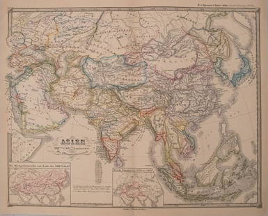
Sold2017Perthes: Antique Map of Asia in 15th Century, 1855Map: 1855 Perthes Map of Asia in 15th Century -- Asien gegen die Mitte des Funften Jahrhunderts... Date Printed: 1855, Gotha Cartographer: J Perthes Size: 12.9 x 16.5 in. Condition: Very good-excellenSee Sold Price
Sold2017Perthes: Antique Map of Asia in 13-14th Centuries, 1855Map: 1855 Perthes Map of Asia in the 13th and 14th Centuries -- Asien im XIII-ten & XIV-ten Jahrhundert… Date/Place: 1855, Gotha Cartographer: J Perthes Size: 12.7 x 16 in. Condition: Very good-exceSee Sold Price
Sold2018Gibson: Antique Map of Asia, 1762Title/Content of Map: Asia Date Printed: 1762 Cartographer: GIBSON, J., sc. Size (inches): 6.8x8.6 Attractive illustrated map with early color. Cupid vignette upper left. Please note that this lot hasSee Sold Price
Sold2017Colton: Antique Map of Asia, 1861Map: Colton's Asia Date Printed: 1861 Cartographer: J. H. Colton Material/Medium: Paper Size: 17 1/2" x 14" Condition: Excellent Hand colored, steel engraved. Printed in New York. From 'Colton's GenerSee Sold Price
Sold2018Bellin: Antique Map of Southeast Asia, 1740Title/Content of Map: Burma, Thailand, Cambodia, Laos & Vietnam Date Printed: 1740-70's Cartographer: J.N. Bellin & J.F. La Harpe Material/Medium: Paper Size: 11 1/2" x 12 1/2" Copperplate engraved. FSee Sold Price
Sold2024Antique Map - Views on the coast of Asia. J. Webber del. Engraved after J. Webber and W. Bligh.Views on the coast of Asia. J. Webber del. (Engraved after J. Webber and W. Bligh. London, G. Nicol and T. Cadell, 1785). Author: Webber, John, 1751-1793; Bligh, William, 1754-1817; Cook, James, 1728-See Sold Price
Sold2022Antique Print - Map of Adakoy Koyu - Ankara - Turkey - Asia Minor - Joseph RouxOriginal copper engraving print originates from ”Recueil des Principaux Plans des Ports et Rades de la Mer Mediterranee …” by Joseph Roux of the edition of 1804. The charts are engraSee Sold Price
Sold2017SDUK: Antique Map of the Turkish Empire in Europe, 1852Map: The Turkish Empire in Europe and Asia With The Kingdom of Greece Publication Date: 1852 Authors: CHARLES KNIGHT/GEORGE COX/S.D.U.K., WALKER, J. & C. Publisher: CHARLES KNIGHT/GEORGE COX/S.D.U.K.See Sold Price
Sold2022LAPIE ORIGINAL ANTIQUE MAP ASIA MINOR 1831L' ASIE MINEURE 1831 SIZE: 25.5 X 20 INCHES APPROX. UNFRAMEDSee Sold Price
Sold2021de Fer, Nicolas 1717 Antique Map. Asia"L'Asie. Suivant les nouvelles decouvertes dont les point principaux sont placez sur les observation" Copper Engraved Map Published 1717, Paris for "Introduction a la Geographie" by Nicolas de Fer. FoSee Sold Price
8 hrs LeftJasper52POLYNESIA/PACIFIC ISLANDS. inc Sandwich/Hawaiian islands. RAPKIN/TALLIS 1851 map$120
3 days LeftTrillium Antique Prints & Rare BooksPtolemy & Magini, pub. 1620 - Map of the Ancient World with Africa, Europe, Asia$50
Featured8 hrs LeftJasper52NW Coast of America & NE Coast of Asia… ROBERTS / DELAROCHETTE. Pacific 1794 map$700(1 bid)
8 hrs LeftJasper52The tropical discoveries of HMS Resolution… New Caledonia Vanuatu. COOK 1776 map$170
8 hrs LeftJasper52Entrée de Norton & Détroit de Bhering. Bering Strait Norton Sound BONNE 1790 map$30(1 bid)
Featured8 hrs LeftJasper52Entrée de Norton & Détroit de Bhering. Bering Strait Norton Sound BONNE 1788 map$30
6 days LeftJasper521784 Pomponius Mela CLASSICAL LATIN WORKS antique SCHOOL PRIZED VELLUM BINDING$200