Sold2024Stanford, Edward 1901 Large Map. Russia since the Accession of Peter ILarge Folio Lithograph Map Published 1901, London for "Stanford's London Atlas of Universal Geography" by Edward Stanford. Centre fold as published. Paper Size: 29 x 21.5 inch (74 x 55cm) Chip to topSee Sold Price
Sold2024Stanford, Edward 1901 Large Map. Russia & PolandLarge Folio Lithograph Map Published 1901, London for "Stanford's London Atlas of Universal Geography" by Edward Stanford. Centre fold as published. Paper Size: 29 x 21.5 inch (74 x 55cm) Good ConditiSee Sold Price
Sold2024Stanford, Edward 1901 Large Map. Geological Map of the British IslesLarge Folio Lithograph Map Published 1901, London for "Stanford's London Atlas of Universal Geography" by Edward Stanford. Centre fold as published. Paper Size: 29 x 21.5 inch (74 x 55cm) Very minor tSee Sold Price
Sold2024Stanford, Edward 1901 Large Map. GreeceLarge Folio Lithograph Map Published 1901, London for "Stanford's London Atlas of Universal Geography" by Edward Stanford. Centre fold as published. Paper Size: 29 x 21.5 inch (74 x 55cm) Margin tearSee Sold Price
Sold2024Stanford, Edward 1901 Large Map. South AfricaLarge Folio Lithograph Map Published 1901, London for "Stanford's London Atlas of Universal Geography" by Edward Stanford. Centre fold as published. Paper Size: 29 x 21.5 inch (74 x 55cm) Tiny marginSee Sold Price
Sold2024Stanford, Edward 1901 Large Map. British Isles - Rainfall and TemperatureLarge Folio Lithograph Map Published 1901, London for "Stanford's London Atlas of Universal Geography" by Edward Stanford. Centre fold as published. Paper Size: 29 x 21.5 inch (74 x 55cm) Good ConditiSee Sold Price
Sold2024Stanford, Edward 1901 Large Map. Sea of Marmara. TurkeyLarge Folio Lithograph Map Published 1901, London for "Stanford's London Atlas of Universal Geography" by Edward Stanford. Centre fold as published. Paper Size: 29 x 21.5 inch (74 x 55cm) Good ConditiSee Sold Price
Sold2024Stanford, Edward 1901 Large Map. SwitzerlandLarge Folio Lithograph Map Published 1901, London for "Stanford's London Atlas of Universal Geography" by Edward Stanford. Centre fold as published. Paper Size: 29 x 21.5 inch (74 x 55cm) Good ConditiSee Sold Price
Sold2024Stanford, Edward 1901 Large Map. AsiaLarge Folio Lithograph Map Published 1901, London for "Stanford's London Atlas of Universal Geography" by Edward Stanford. Centre fold as published. Paper Size: 29 x 21.5 inch (74 x 55cm) Good ConditiSee Sold Price
Sold2024Stanford, Edward 1901 Large Map. North Pole"Map of the Countries Round the North Pole" Large Folio Lithograph Map Published 1901, London for "Stanford's London Atlas of Universal Geography" by Edward Stanford. Centre fold as published. Paper SSee Sold Price
Sold2024Stanford, Edward 1901 Large Map. British Isles - Railway MapLarge Folio Lithograph Map Published 1901, London for "Stanford's London Atlas of Universal Geography" by Edward Stanford. Centre fold as published. Paper Size: 29 x 21.5 inch (74 x 55cm) Very minor tSee Sold Price
Sold2024Stanford, Edward 1901 Large Map. Spain & PortugalLarge Folio Lithograph Map Published 1901, London for "Stanford's London Atlas of Universal Geography" by Edward Stanford. Centre fold as published. Paper Size: 29 x 21.5 inch (74 x 55cm) Left marginSee Sold Price
Sold2024Stanford, Edward 1901 Large Map. Stereographical Map of The British IslesLarge Folio Lithograph Map Published 1901, London for "Stanford's London Atlas of Universal Geography" by Edward Stanford. Centre fold as published. Paper Size: 29 x 21.5 inch (74 x 55cm) Left marginSee Sold Price
Sold2024Stanford, Edward 1901 Large Map. Hydrographical Map of the British IslesLarge Folio Lithograph Map Published 1901, London for "Stanford's London Atlas of Universal Geography" by Edward Stanford. Centre fold as published. Paper Size: 29 x 21.5 inch (74 x 55cm) Good ConditiSee Sold Price
Sold2024Stanford, Edward 1901 Large Map. CyprusLarge Folio Lithograph Map Published 1901, London for "Stanford's London Atlas of Universal Geography" by Edward Stanford. Centre fold as published. Paper Size: 29 x 21.5 inch (74 x 55cm) Good ConditiSee Sold Price
Sold2020London - Stanford, Edward C1860 Large Folding Map"Map of the Environs of London Reduced from the Ordnance Survey" Steel Engraved Map Published C1860, London by Edward Stanford. Reduced from the Ordnance Survey. Fine original hand colour. Contained iSee Sold Price
Sold2019Sketch of the Acquisitions of Russia Since theTitle: Sketch of the Acquisitions of Russia Since the Accession Of Peter 1st. to The Throne. Publication Date: 1842 Cartographer: ARROWSMITH, JOHN Publisher: J. ARROWSMITH Size: 17.1Height - 23.75WidtSee Sold Price
Sold20221851 Tallis Map of European Russia -- Russia in Europe Showing the Territorial Acquisitions SinceTitle: 1851 Tallis Map of European Russia -- Russia in Europe Showing the Territorial Acquisitions Since the time of Peter the Great Cartographer: J Tallis Year / Place: 1851 c., London Map DimensionSee Sold Price
Sold2017Lot of 6 Antique Celestial MapsLot of 6 Antique Celestial Maps. Inscribed "Drawn by W. Newton - W. Clarke Arch." These prints are further inscribed "Edward Stanford - London (publisher)". Dated "Noanno 1830". They remain in very niSee Sold Price
Sold2023(CASE MAPS.) Group of 9 nineteenth-and-early-twentieth-century engraved or lithographed case maps of(CASE MAPS.) Group of 9 nineteenth-and-early-twentieth-century engraved or lithographed case maps of various locations. Individual photographs on request. Vp, vd - Edward Stanford. A Map of China. 43&See Sold Price
Sold2024EDWARD MITCHELL BANNISTER FARMHOUSE WITH SAILBOATSBannister, Edward Mitchell (1828-1901) - oil painting. Oil on board - signed lower left. A large farmhouse with cows in the pasture can be seen on the shoreline as sailboats enjoy beautiful day. BoardSee Sold Price
Sold2024AFRICA VEGETATION. with vertical distribution of vegetation. Mauritius 1901 mapTITLE/CONTENT OF MAP: 'Africa-Characteristic Vegetation; Inset maps of Ascension; St. Helena; Mauritius' DATE PRINTED: 1901 IMAGE SIZE: Approx 33.5 x 41.0cm, 13.25 x 16 inches (Large); Please note thaSee Sold Price
Sold2018MURAT KABOULOV (1939-2010) ORIGINAL OIL ON CANVASVery large Murat Kaboulov (1939-2010) Impressionist oil on canvas of a cafe interior. Born and educated in Russia, Murat Kaboulov has lived and worked in Brentwood, Tennessee since 1992 until the endSee Sold Price
Sold2023Large Peter Fillerup Western Motif ChandelierLate 20th Century, Rawhide Tipi Finial And Bronze Hook Supports Over Drum With Bronze Figures Of American Indians On Horseback, Hand Painted Segmented Stained Glass Drum Cover And Bowl, Eight Lights.See Sold Price
5 days LeftSwann Auction Galleries(CASE MAPS.) Group of 7 nineteenth-and-early-twentieth-century engraved or lithographed maps of$500
5 days LeftSwann Auction Galleries(CASE MAPS.) Group of 7 nineteenth-and-early-twentieth-century engraved or lithographed maps of$1,100
5 days LeftSwann Auction Galleries(UNITED STATES -- RAILROADS.) Edward Stanford. Stanford's Map of the United States Showing the$500
4 days LeftJasper521896 STANFORD'S COMPEDIUM of GEOGRAPHY & TRAVEL ASIA 2 VOLS. antique ILLUSTRATED$220
4 days LeftJasper52North America Sheet III West Canada With Parts of New York, Pennsylvania and Michigan$30
Jun 15Crescent City Auction GalleryPair of New Orleans Sanborn Fire Insurance Mock-Up Skeleton Maps of the French Quarter, 1910-1911,$250
Jun 16Pasadena Antique Warehouse18th Century Large Russian Orthodox Icon Depicting Mary and Infant Jesus$3,250
Jun 20ARTMAXIMUM[Large]. Russian icon "The Queen Did Stand...", the centerpiece of the Deisis tier of the€200(1 bid)
Jun 20ARTMAXIMUM[Large]. Russian icon "Transfiguration of Christ". - Russia, Volga region, late 18th cent. - early€200
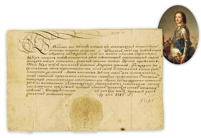
Jun 26University ArchivesPeter the Great 1717 DS Recruiting German Craftsmen, Notably Shipbuilders, Fascinating and Stunning!$4,000


![[Large]. Russian icon "The Queen Did Stand...", the centerpiece of the Deisis tier of the (1 of 1)](https://p1.liveauctioneers.com/6171/331358/178722565_1_x.jpg?height=282&quality=70&version=1716885834)
![[Large]. Russian icon "Transfiguration of Christ". - Russia, Volga region, late 18th cent. - early (1 of 1)](https://p1.liveauctioneers.com/6171/331358/178722581_1_x.jpg?height=282&quality=70&version=1716885834)