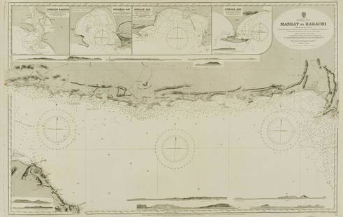
Sold2022Middle East.- Oman.- Admirality Hydrographic Office (The) Maskat to Karachi, engraved chart, 1916.Middle East.- Oman.- Admirality Hydrographic Office (The) Maskat to Karachi, showing the coast from Maskat to Karachi, the Gulf of Oman, with inset maps of Sonmoyani Harbour, Chahbar Bay, Gwatar Bay aSee Sold Price
Sold2018West Indies the Bahama Islands Exuma to New ProvidenceTitle/Content of Map: West Indies the Bahama Islands Exuma to New Providence Date Printed: 01/07/1975 Cartographer: HYDROGRAPHIC OFFICE. ROYAL NAVY Size (inches): 38X25 Detailed nautical chart. CopiouSee Sold Price
Sold2023Venezuela coast. Aruba Bonaire Curacao. ADMIRALTY sea chart 1894 (1955) mapSouth America - North Coast - Tortuga to Cabo la Vela // Catia de la Mar' by From the latest Documents in the Hydrographic Office with additions and corrections from United States and Netherlands GovtSee Sold Price
Sold2017Naval Chart of the Pacific and Western AtlanticU.S. CONGRESS, HYDROGRAPHIC OFFICE. U.S. NAVY, 1894, Folio – 22.25 H x 25.50 W Inches, Congressional reprint of a Navy chart that shows Trust terriories claimed by Britain, France and Germany. NiceSee Sold Price
Sold2024Bosporus & Constantinople 1839 British Admiralty Nautical ChartScarce 1839 original British Admiralty Nautical Chart for the Bosporus or Channel of Constantinople. Published according to Act of Parliament at the Hydrographic Office of the Admiralty May 1st 1839.See Sold Price
Sold2017Dépôt de la Marine: Chart of Martinique Harbors, 1828Map: Plan des Havres du Robert et du Francois (Ile de la Martinique) Cartographer: Depot-General de la Marine Place & Date: Paris / 1828 Size: 35 1/2" x 24 1/2" A large-scale French Hydrographic OfficSee Sold Price
Sold20221888 Pilot Chart of the North Atlantic OceanPilot Chart of the North Atlantic Ocean, March 1888, by the Hydrographic Office U.S. Navy. Printed in grey, black, blue, and red inks. Good condition; some age toning, small separations at some fold cSee Sold Price
Sold2019Four Maps by the Hydrographic Office U. S. Navy,Four Maps by the Hydrographic Office U. S. Navy, consisting of "English Channel, Eastern Sheets," 1935, H. - 41 in., W.- 27 1/2 in.; "English Channel, Middle Sheet," 1938, H. - 42 in., W. -27 7/8 in.;See Sold Price
Sold2021Three South Carolina MapsPreliminary Chart of Port Royal Entrance, Beaufort Chechessee and Colleton Rivers... U.S. Coast Survey Office, Superintendent A. D. Bache, triangulation by C. O. Boutelle... 1859, single sheet, engravSee Sold Price
Sold2019Two Maps by the Hydrographic Office U. S. Navy,Two Maps by the Hydrographic Office U. S. Navy, consisting of "China- East Coast- Hwangpoo River, Kaokiao Creek to Yangtzepoo Creek," 1931, H. - 42 in., W. - 30 in.; together with "China- East Coast-See Sold Price
Sold2019Three Maps by the Hydrographic Office U. S. Navy,Three Maps by the Hydrographic Office U. S. Navy, consisting of "North Pacific Ocean, Marshall Islands, Northern Portion," 1945, H. - 32 in., W. - 50 in.; "France, West Coast, Le Sabe to D'Olonne," anSee Sold Price
Sold2022FELLERS PERSONAL US NAVY DEPT AMERICAN PRACTICALIncredible, Robert W. Feller's personal 1938 Revised edition no.9 AMERICAN PRACTICAL NAVIGATOR published by the UNITED STATES NAY DEPARTMENT HYDROGRAPHIC OFFICE. The presence of this book upon openingSee Sold Price
Sold2022§ BANKSY (BRITISH 1974-) FLYING COPPER - 2004Screenprint, 234/600, signed in print, numbered in pencil to margin This work is accompanied by a Certificate of Authenticity issued by Pest Control Office.(the sheet 100cm x 70cm (39.25in x 27.5in))See Sold Price
Sold2021Gustav Klimt (Austrian, 1862-1918)Gustav Klimt (Austrian, 1862-1918) , "Italian Landscape", Plate 23, collotype, from Eine Nachlese, Klimt and Eisler, Vienna, Austrian State Printing Office, 1931, sheet 18 1/2 in. x 17 7/8 in., sightSee Sold Price
Sold2020(EROTICA.) Group of 3 Chinese or Japanese shunga(EROTICA.) Group of 3 Chinese or Japanese shunga albums. Np, circa mid-nineteenth century 16 ink and watercolor drawings of a couple in various love-making positions on two sheets of laid paper joinedSee Sold Price
Sold2022Jean Carlu GIVE 'EM BOTH BARRELS Color lithograph poster, framedJean Carlu (1900-1997) GIVE 'EM BOTH BARRELS Color lithograph poster, 1941, laid on linen, printed by the U.S. Government Printing Office, Washington, D.C., framed. Sheet 30 1/4 x 39 3/4 inches; 768 xSee Sold Price
Sold2020(CELESTIAL.) Cellarius, Andreas. 2 double-page engraved(CELESTIAL.) Cellarius, Andreas. 2 double-page engraved celestial charts. 19¼x23½ inches each sheet size, wide margins; attractively hand-colored with gold highlights; center folds strengtheSee Sold Price
Sold2022Clara Barton's Own Initial Engraved Silver Spoons and She Sends Impressions of Boston toClara Barton's Own Initial Engraved Silver Spoons and She Sends Impressions of Boston to Correspondent Returning to Massachusetts after her position in the U.S. Patent Office in Washington, D.C. was eSee Sold Price
Sold2021GOOS, PIETER - Caribbean Islands Sea Chart 1666GOOS, Pieter (1616-1675) . Pascaert Vande Caribes Eylanden. Amsterdam: 1666. Engraved sea chart, period hand-colouring in outline. Sheet size: 21 1/2 x 25 inches. Minor age toning. Fine seventeenth ceSee Sold Price
Sold2022Map on cloth of part of Afghanistan c.1878Photozincographed map on cloth of a portion of Afghanistan: 'Afghan'... Enlarged at the Survey Office in Dehra Dun October 1878. Sheet size: 33 7/8 x 22 5/8 inches; 860 x 580mm, with some routes, bordSee Sold Price
Sold2016CARLOS CAPELAN (Uruguayan, b. 1948)Three Indian ink, red ochre and earth on Baltic Sea nautical charts; All signed; 44" x 30" (sheet, each); Provenance: Private Collection, New York CitySee Sold Price
Sold2020MORTIER, PIERRE. Carte Particuliere de Virginie,MORTIER, PIERRE. Carte Particuliere de Virginie, Maryland, Pennsilvanie, la Nouvelle Jarsey Orient et Occidentale. Large double-page engraved chart of the Chesapeake Bay. 25x37 inches sheet size, wideSee Sold Price
Sold2015Prototype 'SF CH GL 000' chair from the first postStefan Diez. Prototype 'SF CH GL 000' chair from the first post production series, 2012/13. H. 80 x 54 x 57 cm. Made by Stefan Diez Office, Munich for Schellmann Furniture, Munich. Galvanised sheet stSee Sold Price
Sold2017De Wit Portolan Sea Chart of EuropeTotius Europae Victoria... Frederic De Wit (1630-1706). Engraved map with original hand color. Amsterdam, 1675. 20 x 35 1/2 inches sheet, 27 1/2 x 43 inches framed. “The most striking and decorativeSee Sold Price
5 days LeftChinwe Russell AuctionsDignity BY Nnaemeka Emmanuel Nworie Created in 2022 with Acrylic on canvas Original Artwork£5,000
Oct 06Paul Arsenault AuctioneersRare Antique 1700's "A New and Correct Chart of the Sea Coast of New-England, from Cape Codd to$100
Oct 05Stanford AuctioneersHELMUT NEWTON - Office Love, Paris - Original vintage color photolithograph$400
Oct 04Stanford AuctioneersHELMUT NEWTON - Office Love, Paris - Original vintage color photolithograph$600
21 hrs LeftJasper52Progress Chart of the Survey of the Northern & North Western Lakes July 1st 1875.$50
3 days LeftFrost & NicklausHeroes Quick Step, 1836 Antique Hand Litho, American Folk Art, Military Music$50
3 days LeftFrost & NicklausCooke, US Soldier, 1840 Antique Hand Lithograph, Hall Quick Step, Military Music$50
3 days LeftFrost & NicklausGuardsman, American Folk Art, Antique 1836 Hand Litho, Tucker Quick Step$50
Oct 12Fleischer's Auctions[BENJAMIN FRANKLIN] Document Signed as President of Pennsylvania$450(2 bids)
BonhamsBanksy (British, born 1974) Grannies Screenprint in colours, 2006, on wove paper, numbered 447/5...£10,000
BonhamsBanksy (British, born 1974) Applause (LA Edition) Screenprint in colours, 2006, on wove paper, n...£8,000(1 bid)
2 days LeftJasper52OS #44 Cotswolds. Cheltenham Broadway Burford Moreton Gloucestershire 1828 map$300
BonhamsHenri de Toulouse-Lautrec (French, 1864-1901) Elles Lithograph in colours, 1896, on thin wove pa...£1,400


![[MAPS] DOUBLE-PAGE. LOT OF 4 SOLD TOGETHER (1 of 4)](https://p1.liveauctioneers.com/8124/343618/186530168_1_x.jpg?height=282&quality=70&version=1726178725)


![[BENJAMIN FRANKLIN] Document Signed as President of Pennsylvania (1 of 3)](https://p1.liveauctioneers.com/7226/343781/186766610_1_x.jpg?height=282&quality=70&version=1726333566)


![[CIVIL WAR]. BARNES, Joseph K. (American, 1817-1883) (Surge... (1 of 8)](https://p1.liveauctioneers.com/928/342606/186002947_1_x.jpg?height=282&quality=70&version=1725643038)


