Sold2022Map on cloth of part of Afghanistan c.1878Photozincographed map on cloth of a portion of Afghanistan: 'Afghan'... Enlarged at the Survey Office in Dehra Dun October 1878. Sheet size: 33 7/8 x 22 5/8 inches; 860 x 580mm, with some routes, bordSee Sold Price
Sold20231817 Hall Map of Persia to Kazakhstan -- Map of the Eastern Part of Persia with Afghanistan,Title: 1817 Hall Map of Persia to Kazakhstan -- Map of the Eastern Part of Persia with Afghanistan, Bactriana, Trans-Oxiana &c Cartographer: S Hall Year / Place: 1817, London Map Dimension (in.): 20x1See Sold Price
Sold2018Sidney Hall: Antique Map of British India & AfghanistanTITLE/CONTENT OF MAP: 'Hindustan, with part of Caubul' British India & Afghanistan. DATE PRINTED: 1856 IMAGE SIZE: Approx 41.0 x 28.5cm, 16 x 11.25 inches (Large) TYPE: Antique atlas map with originalSee Sold Price
Sold2023CABOOL PUNJAB & BELOOCHISTAN Pakistan Afghanistan Lahore. RAPKIN/TALLIS 1851 mapTITLE/CONTENT OF MAP: 'Cabool, The Punjab and Beloochistan' The map covers modern Pakistan, Afghanistan, and part of India. Vignettes: Boats on the Indus; Sultan Mahmoud's Minars and Fortress - GhuzneSee Sold Price
Sold2021CABOOL PUNJAB & BELOOCHISTAN. Pakistan AfghanistanTITLE/CONTENT OF MAP: 'Cabool, The Punjab and Beloochistan' The map covers modern Pakistan, Afghanistan, and part of India. Vignettes: Boats on the Indus; Sultan Mahmoud's Minars and Fortress - GhuzneSee Sold Price
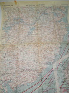
Sold2023WWII 1943 USAAF Army Air Force Silk Pilot Escape Officers Cloth Map of ChinaWWII 1943 AAF Southeast China Cloth Silk Officers Map. This map was part of the Asiatic Series. The approximate size is 20 x 27 inches. Excellent condition with tape residue and a chemical type smellSee Sold Price
Sold20211892 Map of Persia and AfghanistanTitle: 1892 Map of Persia and Afghanistan Medium: Ink on Paper Dimensions: 21"X13.5" Map of Persia and Afghanistan dated 1892. Part of Bacon's Commercial and Library Atlas of the World. Published by GSee Sold Price
Sold20211886 Persia and Afghanistan MapAuthor: Blackie Title: 1886 Persia and Afghanistan Map Medium: Ink on Paper Dimensions: 21"X15" Map of Persia and Afghanistan dated 1886. Part of the Imperial Atlas of Modern Geography. This was the rSee Sold Price
Sold20211882 Map of PersiaAuthor: Blackie Title: 1882 Map of Persia Medium: Ink on Paper Dimensions: 22"X15" Map of Persia, Afghanistan and Beloochistan dated 1882. It captures the Red Sea. Part of the Comprehensive Atlas & GeSee Sold Price
Sold2021EARLY FRAMED NYC MAP, PART OF WARD 9, NEW YORK CITYEARLY FRAMED NYC MAP, PART OF WARD 9, NEW YORK CITY PART OF SECTION 2, FRAMED AND MATTED, MAKER OR DATE UNKNOWN. MAP MEASURES 23" X 32". IN VERY NICE ESTATE CONDITION, FROM WOODSTOCK, N.Y. ESTATE.See Sold Price
Sold2022Tallis, John (Pub) 1854 Map. Part of South AustraliaSteel Engraved Map Published 1854-55 by John Tallis, London for "The British Colonies; Their History, Extent, Condition and Resources" by Robert Montgomery Martin. Drawn & Engraved by John Rapkin. CenSee Sold Price
Sold2021Tallis, John (Pub) 1852 Map. Part of South AustraliaSteel Engraved Map with Original Outline Hand Color Published 1852-56 by John Tallis, London for "The Universal Pronouncing Dictionary" by Thomas Wright. Drawn & Engraved by John Rapkin. Centre fold aSee Sold Price
Sold2021Framed Printed Map. Parts of Mediterranean Sea and counFramed Printed Map. Parts of Mediterranean Sea and countries north. -- Dimensions: H: 13 inches: W: 19 inches: D: 24 inches ---See Sold Price
Sold2022MATTEL Barbie, big treasure chest, clothes, parts and outfits, accessories, different periods,MATTEL Barbie, big treasure chest, clothes, parts and outfits, accessories, different periods, richly German Description MATTEL Barbie, gr. Fundkiste, Kleidung, Einzelteile u. Outfits, Zubehör, uSee Sold Price
Sold2022Ideal Tammy Doll Case with a Small Doll, Clothes, Parts, EtcIdeal Tammy Doll Case with a Small Doll, Clothes, Parts, EtcSee Sold Price
Sold2023Four Seasons by Carol MothnerFour Seasons by Carol Mothner. Oil on board, signed (LR) Sight image is 14 3/4" x 12 3/4" Condition - some stains on cloth part of frame , some minor scratches on paintingSee Sold Price
Sold2023Hornaday (2) 19TH C. Hunting Books SIGNEDTwo (2) William Hornaday inscribed and signed illustrated books. Includes: 1) Two Years in the Jungle. 1886. Charles Scribner's Sons. 512 pp. with fold out map. Cloth pictorial covers. 2) The Man WhoSee Sold Price
Sold2019BAHAMAS. 'Isles Lucayes'. Abacoa Lucaioneque CurateoTITLE OF THE MAP: 'Isles Lucayes' The east coast of Florida is on the left hand side of the map. Part of Cuba is shown at the bottom of the map DATE PRINTED: 1683 IMAGE SIZE: Approx Overall page sizeSee Sold Price
Sold2017Mallet: Antique Map of Isles Lucayes, Bahamas, 1683Title/Content of Map: 'Isles Lucayes' The east coast of Florida is on the left hand side of the map. Part of Cuba is shown at the bottom of the map. Bahamas, Abacoa Lucaioneque Curateo Ciguateo Date PSee Sold Price
Sold201927" Tall Cherub Painted Bronze CandlestickMeasures 27" x 13". Very good condition with orange paint on the cloth part.See Sold Price
Sold2024Crazy Horse by Mari Sandoz 1942 1stCrazy Horse by Mari Sandoz. 1942 1st with clipped dust jacket. Alfred A. Knopf. 428 pp. with map. Cloth covers. Measures 8.75 in. x 6 in. x 1.75 in. Provenance: Washington State Estate Collection. IfSee Sold Price
Sold2019Group of Early Maps of New Mexico(1) Rand, McNally & Co.'s New Commercial Atlas of America - Map of New Mexico. Copyright, 1911, by Rand, McNally & Co. 23 3/4 x 31 1/4 inches (2) Geologic Map of New Mexico. Two-part folding map. PartSee Sold Price
Sold2017Weller: Map of Afghanistan & Beloochistan, 1863Map: 'Afghanistan, Beloochistan, Pakistan. Kabul Karachi Quetta.' Date Printed: 1863 Image Size: Approx 43.5 x 31.0cm, 17.25 x 12.25 inches (Large) Type: Antique map with original outline colour CondiSee Sold Price
Sold20211890 Jerusalem and Palestine MapTitle: 1890 Jerusalem and Palestine Map Author: Mast Medium: Ink on Paper Dimensions: 13.5"X10.5" Map of Jerusalem and Palestine dated 1890. Published by Mast and Crowell. Dual Map. Part of the PeerleSee Sold Price
4 days LeftFreeman's | HindmanTHOREAU, Henry David (1817-1862). Walden: or, Life in the Woods. Boston: Ticknor & Fields, 1854.$3,000
332 Lots AwayHermann Historica GmbHA saddle cloth part for troopers of the Guard Cuirassier RegimentSee Sold Price
Crawford Family Auctions LLCFramed print of Map of Part of the Island of Hawaii & Sandwich Islands, w/COA$20
Jun 13Julien's AuctionsThe Lord of the Rings: The Fellowship of the Ring | Spanish Home Video Release Announcement Box$100
4 days LeftFreeman's | HindmanMELVILLE, Herbert (1819-1891). Typee: A Peep at Polynesian Life. During a Four Months' Residence in$200
3 days LeftJasper521775-1780 North West Africa with Cape Verde and Canary Islands. By Bonne and Raynal$20
3 days LeftJasper521581 Ortelius Map of Tuscany [with] Corsica [with] Ancona -- Senensis Ditionis, Accurata Descrip [on$140
4 days LeftJasper52Partie de la Coste d'Afrique depuis Tanit…' Southern Mauritania BELLIN 1746 map$20


![1581 Ortelius Map of Tuscany [with] Corsica [with] Ancona -- Senensis Ditionis, Accurata Descrip [on (1 of 1)](https://p1.liveauctioneers.com/5584/331064/178466435_1_x.jpg?height=282&quality=70&version=1716924723)


