Sold2023Transcontinental Cost to Coast Plane and Train Illustrated MapRand Mcnally & Co. ca. june 1929See Sold Price
Sold20201893 1ed FLORIDA East Coast Jacksonville Railroad1893 1ed FLORIDA East Coast Jacksonville Railroad Illustrated Photogravure MAP Helen Ingram provided the text for this early first edition brochure of Florida by Jacksonville, St. Augustine and the InSee Sold Price
Sold20241780 Eyles Irwin "A Series Of Adventures In The Course Of A Voyage Up The Red Sea"On the coast of Arabia and Egypt; and of A Route Through The Defarts Of Thebais, hither to unknown to the European traveller, in the year 1777, Illustrated with maps and cutsSee Sold Price
Sold20211861 MAP OF COAST OF SOUTH CAROLINAOriginal 1861 Frank Leslies Illustrated News Coast of South Carolina Wood Engraving with later hand coloring. Professionally framed. In frame measures 28"x31"x1". Weight 9 pds. NO IN HOUSE SHIPPING. PSee Sold Price
Sold2021Northwest Coast of North America 1840Memoir, Historical and Political on the Northwest Coast of North America, and the Adjacent Territories; Illustrated by a Map and a Geographical View of Those Countries by Robert Greenhow. US. Senate 2See Sold Price
Sold2016Coast of South Carolina (Great Naval Expedition), 1861Original wood engraving from Frank Leslie's Illustrated Newspaper, November 23, 1861. Map is of Port Royal and naval & military operations of the Great Naval Expedition of Commodor DuPont & General ShSee Sold Price
Sold2023VERY RARE 1876 TRANS CONTINENTAL RR POCKET MAP 5 ft. LONGThe rare, profusely illustrated panoramic fold-out pocket map with boards displays related advertising and timetables along with the following interesting text: This Great Overland Route is composed oSee Sold Price
Sold2018Jefferys / Sayer: Pacific Coasts Nicaragua / Costa RicaPart of the Provinces of Costa Rica and Nicaragua with the Lagunas. A magnificent, large-scale map of a small slice of the Pacific coasts of Nicaragua and Cost Rica, from San Miguel (now in El SalvadoSee Sold Price
Sold2022Williams Trains Freight CarsO gauge, Classic Freight Cars, no. 22 C and NW boxcar, no. 26 LV MAP boxcar, no. 56 RIR boxcar, and no. 86 B and M boxcar, with Atlantic Coast Line HC09 quad hopper with cover and coal load, with origSee Sold Price
Sold2022(4) Factory Sealed Trans-Con Lionel, Centennial EditionAll four of these tins are the Centennial Edition, Lionel Trains, Trans-Con. All are in the original tin with original factory wrap. Contains interactive CD, map of the Transcontinental Railroad, an NSee Sold Price
Sold2022VARIOUS ARTISTS. [ILLUSTRATED MAPS]. Group of 3 posters. 1930s-1940s. Sizes vary.VARIOUS ARTISTS [ILLUSTRATED MAPS]. Group of 3 posters. 1930s-1940s. Sizes vary. Condition varies, generally A- / A. Group includes: A Map of Western Long Island (1939), by Rolf Klep; Michigan / UpperSee Sold Price
Sold2022(PICTORIAL MAPS.) Charles Turzak & Henry Chapman. An Illustrated Map of Chicago • Youthful(PICTORIAL MAPS.) Charles Turzak & Henry Chapman. An Illustrated Map of Chicago • Youthful City of the Big Shoulders • Restless • Ingenious • Wilful • Violent • ProSee Sold Price
Sold2018J. P. Pinchon, illustrated map of France c. 1951J. P. Pinchon, illustrated map of France c. 1951, Joseph Porphyre Pinchon (French, 1871-1953), partially completed map of France, c. 1951, watercolor and oil on paper mounted on linen, unframed, whimsSee Sold Price
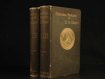
Sold20241885 Civil War 1ed Memoirs of Union General Ulysses S. Grant Illustrated MAPS 2v1885 Civil War 1ed Memoirs of Union General Ulysses S. Grant Illustrated MAPS 2v “The art of war is simple enough. Find out where your enemy is. Get at him as soon as you can. Strike him as hard asSee Sold Price
Sold2021Dutch Nicolaes Visscher I Map of New Amsterdam, ca 1690Nicolaes Visscher I. Map of Northeast with Early View of New York City. Ca. 1690 to 1729. A finely hand-colored example of Nicolaes Visscher I's illustrated map of the Northeast of America with an insSee Sold Price
Sold2023Original Vintage Indochine Francaise Map by Lucien Boucher 1935 Vietnam Laos CambodiaAs one can only imagine, travel in the Far East in the 1920's must have been a challenging adventure. This well illustrated map poster by master artist, Lucien Boucher shows the various routes once coSee Sold Price
Sold2024Emil Heilborn Untitled Gelatin Silver PrintEmil Heilborn (Swedish, 1900-2003), Untitled (Plane, Train, and Boat), Gelatin Silver Print, signed lower right, inscribed to verso with Robert Mann Gallery label, silvered wood frame. Image: 9" H x 7See Sold Price
Sold20181885 1ed Civil War Memoirs Union General Ulysses Grant1885 1ed Civil War Memoirs Union General Ulysses S Grant Illustrated MAPS 2v “The art of war is simple enough. Find out where your enemy is. Get at him as soon as you can. Strike him as hard as youSee Sold Price
Sold20201756 Gulliver’s Travels Jonathan Swift English Classic1756 Gulliver’s Travels Jonathan Swift English Classic Illustrated Maps FAMOUS “Every man desires to live long, but no man wishes to be old.” ― Jonathan Swift, Gulliver’s Travels JonathaSee Sold Price
Sold20231853 U.S. Coast Survey Map of New Orleans1853 U.S. Coast Survey Map of New Orleans, Lake Pontchartrain and the Mississippi Delta hand-colored lithograph, inscribed "U.S. Coast Survey, A. D. Bache Superintendent, Sketch H, Showing the progresSee Sold Price
Sold2021US Coast Survey Map of the Louisiana CoastAntique US Coast Survey Map of the Louisiana Coast , "U.S. Coast Survey, A.D. Bache, Superintendent", 1855, lithograph, with later hand-coloring, showing Vermillion Bay, LA to Mobile Bay, AL, sight 15See Sold Price
Sold2021Antique Coast Survey Map of the Atchafalaya BayAntique Coast Survey Map of the Atchafalaya Bay , "Preliminary Chart of Atchafalaya Bay Louisiana... A.D. Bache, Superintendant", 1858, lithograph, with later hand-coloring, sight 24 1/2 in. x 31 1/4See Sold Price
Sold2019[Map] Coast of Georgia, S.C., Florida, SavannahHughes, Andrew. "A Draught of South Carolina and Georgia from Sewee to St. Estaca." London: W. Mount and T. Page, [1778.] Measured from neatlines 32.25" x 18". Professionally mounted at points to acidSee Sold Price
Sold20241865 HISTORY of INDIAN WARS in NEW ENGLAND 2 volumes ILLUSTRATED w/ MAP antiqueThe History of The Indian Wars in New England from the First Settlement to the Termination of the War with King Philip, in 1677. by William HUBBARD (1621?-1704) Roxbury, Mass.: printed for W. Elliot WSee Sold Price
4 days LeftSchilb Antiquarian Rare Books1859 AFRICA VOYAGES Barth Timbuktu Tripoli SLAVES Illustrated Slavery MAP African$62(4 bids)
4 days LeftSchilb Antiquarian Rare Books1883 FLORIDA for Tourists & Settlers Illustrated Fort Barrancas MAP Fine BINDING$90(5 bids)
10 hrs LeftHunt and Peck Estate Services, Inc.1779 J. Carver "Travels Through The Interior Parts of North-America"$50(1 bid)
5 days LeftFleischer's Auctions1755 Map Partie de l'Amerique Septentrionale, qui comprend Le Cours de L'Ohio...$150(2 bids)
6 hrs LeftMynt AuctionsRoy Harris Signed 1958 Sports Illustrated 8/18 Autographed Boxer PSA/DNA AJ99156$10
1024 Lots AwayMynt AuctionsParamount by Kirk Sterling Silver Cheese Plane with Flat Blade HHWS Custom$10
503 Lots AwayMynt AuctionsRapallo by Lunt Sterling Silver Cheese Plane with Flat Blade HHWS Custom 8 1/4"$10
6 hrs LeftMynt AuctionsSteve Carlton HOF Signed 1973 Sports Illustrated NOLABEL Phillies PSA/DNA 185019$10
6 hrs LeftMynt AuctionsGeorge Archer Signed 1969 Sports Illustrated 4/21 Autographed PGA Golf PSA/DNA$10
6 hrs LeftMynt AuctionsARCHIE GRIFFIN OHIO STATE BUCKEYES 74/75 H.T. JSA/COA SIGNED SPORTS ILLUSTRATED$10
6 hrs LeftMynt AuctionsMIKE ROZIER NEBRASKA CORNHUSKERS HEISMAN 1983 JSA/COA SIGNED SPORTS ILLUSTRATED$10


![VARIOUS ARTISTS. [ILLUSTRATED MAPS]. Group of 3 posters. 1930s-1940s. Sizes vary.: VARIOUS ARTISTS [ILLUSTRATED MAPS]. Group of 3 posters. 1930s-1940s. Sizes vary. Condition varies, generally A- / A. Group includes: A Map of Western Long Island (1939), by Rolf Klep; Michigan / Upper](https://p1.liveauctioneers.com/199/255737/132982810_1_x.jpg?height=310&quality=70&version=1658424802)


![[Map] Coast of Georgia, S.C., Florida, Savannah: Hughes, Andrew. "A Draught of South Carolina and Georgia from Sewee to St. Estaca." London: W. Mount and T. Page, [1778.] Measured from neatlines 32.25" x 18". Professionally mounted at points to acid](https://p1.liveauctioneers.com/3532/146911/74242108_1_x.jpg?height=310&quality=70&version=1564368564)

![[WWI] P.T. Sherman's WWI Service Record & Books (1 of 8)](https://p1.liveauctioneers.com/7226/322253/173251586_1_x.jpg?height=282&quality=70&version=1710004847)


