Sold2023USC&GS Map, Sombrero Key to Sand Key, Florida Gulf CoastA colored map depicting the area of the Gulf Coast from the Sombrero Key to the Sand Key. Publishing stamp by "The U.S Coast and Geodetic Survey" located on bottom. Issued: 1940 Dimensions: 43"L x 35"See Sold Price
Sold2023USC&GS Map, Sombrero Key to Sand Key, Florida Gulf CoastA color map depicting the land and sea area of the Sombrero Key to the Sand Key. Publishing stamp by "The U.S Coast and Geodetic Survey" located on bottom. Issued: 1954 Dimensions: 43.5"L x 36See Sold Price
Sold2023USC&GS Map, Alligator Reef to Sombrero Key, FL Gulf CoastTitle "USC&GS Map, Alligator Reef to Sombrero Key, Florida Gulf Coast". A color map depicting the land and sea area of Alligator Reef to the Sombrero Key. Publishing stamp by "The U.S Coast and GeodetSee Sold Price
Sold2023DOC Map, Alligator Reef to Sombrero Key, U.S Gulf CoastA color map depicting the area of Alligator Alley to the Sombrero Key. Publishing stamp by "The U.S Department of Commerce" located on bottom. Issued: 1940 Dimensions: 43.5"L x 34"W ManufacturSee Sold Price
Sold2023USC&GS Map, Alligator Reef to Sombrero Key, U.S Gulf CoastA color map depicting the area of Alligator Alley to the Sombrero Key. Publishing stamp by "The U.S Coast and Geodetic Survey" located on bottom. Issued: 1940 Dimensions: 43.5"L x 34"W ManufacSee Sold Price
Sold2023USC&GS Map, Sand Key to Rebecca Shoal, U.S Gulf CoastA color map depicting the land and sea area of the Sand Key to the Rebecca Shoal. Publishing stamp by "The U.S Department of Commerce Coast and Geodetic Survey" located on bottom. Issued: 20thSee Sold Price
Sold2023USC&GS Map, Sand Key to Rebecca Shoal, U.S Gulf CoastA map depicting the islands along the gulf coast along with the gulf. Publishing stamp by "The U.S Coast and Geodetic Survey" located on bottom. Issued: 1933 Dimensions: 44"L x 34.5"W Manufacturer: U.See Sold Price
Sold2017SDUK: Antique Map of US Gulf Coast, 1846Title/Content of Map: 'NORTH AMERICA, SHEET XIII., Parts of Louisiana, Arkansas, Mississippi, Alabama & Florida' Native American settlements are named on the map west of the Mississippi, some marked wSee Sold Price
Sold2019US GULF COAST Louisiana Mississippi Alabama FloridaTITLE/CONTENT OF MAP: 'NORTH AMERICA, SHEET XIII., Parts of Louisiana, Arkansas, Mississippi, Alabama, Florida' DATE PRINTED: 1874 IMAGE SIZE: Approx 32.5 x 42.0cm, 12.75 x 16.5 inches (Large) TYPE: ASee Sold Price
Sold2023USC&GS Map, Chatham River to Clam Pass, U.S Gulf CoastA map of the Gulf Coast of Florida from Chatham River to Clam Pass shown in feet. Publishing stamp by "The U.S Coast and Geodetic Survey" located on bottom. Issued: 1931 Dimensions: 43.5"L x 3See Sold Price
Sold2023USC&GS Map, Chatham River to Clam Pass, U.S Gulf CoastA map of the Gulf Coast of Florida from Chatham River to Clam Pass shown in feet. Publishing stamp by "The U.S Coast and Geodetic Survey" located on bottom. Issued: 20th Century Dimensions: 43See Sold Price
Sold2024USC&GS Map, Elliot Key to Florida Bay, Intercoastal WaterwayTitle "USC&GS Map, Elliot Key to Florida Bay, Florida Intercoastal Waterway" Depicts a color map of the Intracoastal Waterway from Key Elliot to the Florida Bay. Publishing stamp by "The U.S Coast andSee Sold Price
Sold2024USC&GS Map, Miami Harbor, Florida East CoastA color map depicting the land and sea area of the Miami Harbor. Publishing stamp by "The U.S Coast and Geodetic Survey" located on bottom. Issued: 1935 Dimensions: 47"L x 28"W Manufacturer: U.S CoastSee Sold Price
Sold2024USC&GS Map, Barnes Sound to Key West, Intercoastal WaterwayTitle "USC&GS Map, Barnes Sound to Key West, Florida Intercoastal Waterway". Depicts a color map of the Intracoastal Waterway from Barnes Sound to Key West. Publishing stamp by "The U.S Coast and GeodSee Sold Price
Sold2023USC&GS Map, Jupiter Inlet to Fowey Rocks, Florida East CoastA color map depicting the land and sea area of the inlet of Jupiter to Fowey Rocks. Publishing stamp by "The U.S Coast and Geodetic Survey" located on bottom. Issued: 1937 Dimensions: 42"L x 3See Sold Price
Sold2023USC&GS Map, Jupiter Inlet to Fowey Rocks, Florida East CoastA color map depicting the land and sea area of the inlet of Jupiter to Fowey Rocks. Publishing stamp by "The U.S Coast and Geodetic Survey" located on bottom. Issued: 1937 Dimensions: 42"L x 3See Sold Price
Sold2023US Hydrographic Office Map, Keppel Isles to Sandy CapeTitle "US Hydrographic Office Map, Keppel Isles to Sandy Cape, East Coast Australia". A map depicting the East Coast of Australia from the Keppel Isles to Sandy Cape. Publishing stamp by "See Sold Price
Sold2023DOC Map, Fowey Rocks to Alligator Reef, Florida East CoastA color map depicting the land and sea area of Fowey Rocks to Alligator Reef. Publishing stamp by "The U.S Coast and Geodetic Survey" located on bottom. Issued: 1921 Dimensions: 46"L x 35"W MaSee Sold Price
Sold2023USC&GS Map, Fowey Rocks to American Shoal, Florida KeysA color map showing the land and sea area of Fowey Rocks to American Shoal. Publishing stamp by "The U.S Coast and Geodetic Survey" located on bottom. Issued: 1940 Dimensions: 38.5"L x 34"W MaSee Sold Price
Sold2023USC&GS Map, Fowey Rocks to American Shoal, Florida KeysA color map showing the land and sea area of Fowey Rocks to American Shoal. Publishing stamp by "The U.S Coast and Geodetic Survey" located on bottom. Issued: 1940 Dimensions: 38.5"L x 34"W MaSee Sold Price
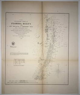
Sold2020(F No.4) Preliminary Chart of Florida Reefs from KeyTitle/Content of Map: (F No.4) Preliminary Chart of Florida Reefs from Key Biscayne to Carysfort Reef... Publication Date: 1855 Cartographer: Totten, Jas./I. Hull Adams Publisher: U.S. Coast Survey DeSee Sold Price
Sold2021Railroad Lock Keys (11), various Florida RR LinesID Marks: LOP&GRR (Live Oak Perry & Gulf RR); JTCO (Jacksonville Terminal Co); FECRY (Florida East Coast RY); ANRR (Apalachicola & Northern RR); SAL (Seaboard Air Line); FECRY (Florida East Coast RY);See Sold Price
Sold2019U S Coast Survey 1896 LG Map. New Orleans Texas Florida"Sketch of General Progress June 30. 1896" Showing Southern, Eastern and Mid West States, incl Florida, Texas, Gulf of Mexico, Georgia etc. Large Lithograph Map Published 1896, Washington for "U.S. CoSee Sold Price
Sold2017Hand-Colored Lithograph Map of the Gulf of MexicoImpressive Hand-Colored Lithograph Map of the Gulf of Mexico, titled "U.S. Coast Survey, A.D. Bache Superintendent, Sketch H, Showing the Progress of the Survey in Section No. 8, 1846-1854", the map iSee Sold Price
BonhamsEAST AFRICA DE WIT (FREDERICK) Occidentalior Tractus Indiarum Orientalium a Promontorio Bonae Sp...£300
13 hrs LeftJasper52Southern Africa Cape of Good Hope-Madagascar ADMIRALTY sea chart 1935 (1955) map$60
1 day LeftRapid Estate Liquidators and Auction GalleryEllen Plankey "Head Study" Signed Charcoal & Chalk$150
Jun 29JM Hobby Supply and Railroad Artifact AuctionsFlorida East Coast RY Rococo Pattern Dinner Plate$30(2 bids)
3 days LeftSimpson Galleries, LLC.JULIUS BIEN (1826-1909) AN AMERICAN CIVIL WAR RECONNAISSANCE MAP, "Map of Texas and Part of New$100
13 hrs LeftJasper52Côte occidentale de l'Afrique. W Africa.Senegal Gambia rivers.D’ANVILLE 1751 map$85
13 hrs LeftJasper52Partie de la Coste de Guinée'. Sierra Leone & Liberia coast. BELLIN 1747 map$40
Jun 12Jasper52Océan Atlantique Sud. Fernando de Noronha. Dépôt de la Marine sea chart 1873 map$260
Jun 12Jasper52Océanique. Partie… Nle Hollande #52. Western Australia SW. VANDERMAELEN 1827 map$320
Jun 13Swann Auction Galleries(YOSEMITE.) James David Smillie. From the New Trail Between Snow's & Glacier Point, Looking East.$750