Sold2023Wagner's Complete map of RichmondPublication Date: c1927 Title: Wagner's Complete map of Richmond Cartographer: A. C. Wagner Co. Publisher: A. C. Wagner Co. Height: 25 Width: 33 Published by The A. C. Wagner Co. Reserve: $120.00 ShipSee Sold Price
Sold2020New and Complete Map of Scotland, And Islands TheretoTitle/Content of Map: New and Complete Map of Scotland, And Islands Thereto Belonging; Cartographer: Date: 1779 Publisher: ROBT. SAYER Size: 46.7Height - 39.7Width "from actual surveys, the Shires proSee Sold Price
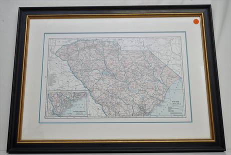
Sold2021HAMMONDS COMPLETE MAP OF SOUTH CAROLINAVintage Hammonds Complete Map of South Carolina. Showing all the railroad routes. c. 1930s. Professionally framed and matted. In frame measures 26 3/4"x20"x 1 1/4". Weight 7 pds. PROVENANCE: A PrivateSee Sold Price
Sold2023Original Vintage c. 1930s Dutch Airline Travel PosterWijga, Jan 1902 - 1978 KNILM - Complete Map of the Airlines Letterpress Print ca. 1938 22.4 x 29.9 in. (57 x 76 cm) Printer: Herdruk E. Fuhri & Co., S'Baia Condition Details: (B+) small tears, creasesSee Sold Price
Sold2021With map of Hudson River Valley 1851Heading: (New York - Hudson River Railroad) Author: Title: Hudson River and the Hudson River Railroad: With a complete map, and wood cut views of the principal objects of interest upon the line PlaceSee Sold Price
Sold20201794 Laurie & Whittle Map of the Caribbean, Mexico andTitle/Content of Map: 1794 Laurie & Whittle Map of the Caribbean, Mexico and Central America -- A New and Complete Map of the West Indies Comprehending All the Coasts and Islands Known by That Name bySee Sold Price
Sold20231936 Complete Illustrated Big Game Fish MapXL Big Game Fish Complete Map, Illustrated Fresh and Salt Water fishing. Marked on bottom. Designed and copyright by Joe. Godfrey JR…Chicago. Number 105. Map depicts the whole of the U.S.A with an iSee Sold Price
Sold2021Color map of California based on 1910 censusHeading: (California) Author: Title: Hammond's Complete Map of California Place Published: New York Publisher:C.S. Hammond & Co. Date Published: 1911 Description: Color foldingSee Sold Price
Sold202118th c. Print England and Wales Road Map by Condor"A New Most Accurate & Complete Map of all the Direct and the Principal Cross Roads in England and Wales". Original detailed map shows distances of major roadways across England and Wales, measured inSee Sold Price
Sold2017Millar: Antique Map of Spain & Portugal, 1768Title/Content of Map: 1768 Millar Map of Spain and Portugal -- A New and Complete Map of Spain and Portugal Date Printed: 1768 c. Cartographer: G Millar Size: 14.3 x 9.3 in. Condition: Good - fair. SeSee Sold Price
Sold20231902 Map of Vermont Highways, Natural Features, Railroad Stations, etc...This is a large, wall hanging 1902 Complete Map of Vermont Showing Highways and Natural Features, with an Index of All Cities, Villages, Post Offices, and Railroad Stations. Railroad routes are also sSee Sold Price
Sold2017Millar Map of Scandinavia, 17681768 Millar Map of Scandinavia -- A New and Complete Map of Norway, Sweeden and Denmark. A nice, handsome map of the Scandinavian countries. From Millar's New Complete & Universal System of GeographicSee Sold Price
Sold20201891 Map of AtlantaAuthor: Cram Title: 1891 Map of Atlanta Medium: Ink on Paper Dimensions: 11.5"X14.5" Map of Atlanta dated 1891. Engraved and published by George Cram in Chicago. One of the first complete maps of AtlaSee Sold Price
Sold2024American Statehood quarters MapNear complete map of American State Hood quarters. (missing Alaska). Painted Quarters Map. We are a veteran owned company. Please look at the pictures carefully to determine what you believe the condiSee Sold Price
Sold2021NY Military Fish and Game MapsNY Military fish and game maps. Belonged to John Bartholf (descent of A. Hamilton). 4 complete maps of the Adirondack 1911.See Sold Price
Sold2022MS. map of Richmond District developmentsHeading: -1870 Author: Title: Manuscript map/plat of a portion of the Richmond District, San Francisco, ownership, homestead associations, etc. Place Published: [San Francisco] Publisher: Date PSee Sold Price
Sold2016Map of Richmond, Virginia by Johnson, 1862 (James,Johnson’s Map of the Vicinity of Richmond, and Peninsular Campaign in Virginia Showing also the interesting localities along the James, Chickahominy and York Rivers. Compiled from the official mapsSee Sold Price
Sold2021Gray, Ormando. Gray's New Map of Richmond HenricoGray, Ormando. Gray's New Map of Richmond Henrico County, Virginiacirca 1878, steel engraving with color, presented in a mid-20th century black wooden frame with gilt liner. This detailed map show theSee Sold Price
Sold2017Johnson: Antique Civil War Map of Richmond, 1862Scarce and important 1862 A. J. Johnson map of the vicinity of Richmond, Virginia, during the American Civil War. Full title: “Johnson’s Map of the Vicinity of Richmond, and Peninsular CaSee Sold Price
Sold2024State Series Quarter Map - Complete & Nice for ChildrenState Series Quarter Map - Complete & Nice for ChildrenSee Sold Price
Sold20231847 Mitchell atlas complete w/all maps in excellent conditionVery scarce 1847 New Universal Atlas published by S. Augustus Mitchell, complete with all maps and in sound, clean condition. Contains 72 lithographed maps as called-for, all with original, full hand-See Sold Price
Sold20181780 1ed RARE Complete VOYAGES Maps Captain Cook Americ1780 1ed RARE Complete VOYAGES Maps Captain Cook America Explorers Africa 32v The best book of its kind! An extremely rare, 32-volume complete set of La Harpe’s ‘General History of Voyages’! ThiSee Sold Price
Sold20181780 1ed RARE Complete VOYAGES Maps Captain Cook1780 1ed RARE Complete VOYAGES Maps Captain Cook America Explorers Africa 32v The best book of its kind! An extremely rare, 32-volume complete set of La Harpe’s ‘General History of Voyages’! ThiSee Sold Price
5 days LeftTrillium Antique Prints & Rare BooksHarris - Map of the Southern Continent (Australia, New Holland)$140(2 bids)
1 day LeftDOYLE Auctioneers & AppraisersSet of Twelve Satirical Anthropomorphic Maps of Europe$400(1 bid)
5 days LeftTrillium Antique Prints & Rare BooksHarris - Map of the World (With Australia and part of New Zealand)$120(4 bids)
5 days LeftTrillium Antique Prints & Rare BooksMoore & Conder - Map of the East India Islands (Includes Philippines, Cambodia, China, Borneo,$75
Jun 27NY Elizabeth 1760 WORLD'S HISTORY ON OLD GERMAN VELLUM, ILLUSTRATED WITH A MAP OF CENTRAL ASIA$100
5 days LeftTrillium Antique Prints & Rare BooksHarris - Map of the West Indies or Antilles Islands with Florida, Louisiana, part of Mexico and$80(2 bids)
5 days LeftTrillium Antique Prints & Rare BooksMoore & Conder - Map of North America with Canada, California as a Peninsula, Great Lakes, Florida$75(1 bid)
1 day LeftJasper521822 MAP of LEEWARD ISLANDS GEOGRAPHICAL STATISTICAL HISTORICAL antique 17.5x22"$120
3 days LeftDalshire InternationalHistoric 1904 Tip Top Weekly Magazine Signed by Baseball Legends Including Ruth & Gehrig$480(5 bids)


![MS. map of Richmond District developments: Heading: -1870 Author: Title: Manuscript map/plat of a portion of the Richmond District, San Francisco, ownership, homestead associations, etc. Place Published: [San Francisco] Publisher: Date P](https://p1.liveauctioneers.com/642/242590/125758412_1_x.jpg?height=310&quality=70&version=1648613138)