Sold2023Vintage National New York 1915 Map All steam and electric railways bookletAll steam and electric railways bookletSee Sold Price
Sold2018Weller: Antique Map of Great Northern Railway, 1863TITLE/CONTENT OF MAP: 'Great Northern Railway (Sheet 1. London to Grantham & Nottingham)' The route (including all branches shown) runs through the towns of London, Hatfield, Hertford, Stevenage, HitcSee Sold Price
Sold2016Nashville Battlefields and TN MapTwo Tennessee related maps. 1st item: A NEW MAP OF TENNESSEE WITH ITS ROADS AND DISTANCES FROM PLACE TO PLACE ALONG THE STAGE AND STEAM BOAT ROUTES by H.P. Tanner, dated 1841, showing counties, canalsSee Sold Price
Sold2018Weller: Antique Map of Northeast Spain, 1863Title/Content of Map: 'Spain &c. (North East sheet)' Catalonia Aragon Navarre. Barcelona-Zaragoza railway. Date Printed: 1863 Image Size: Approx 32.5 x 45.0cm, 12.75 x 17.75 inches (Large) Type: AntiqSee Sold Price
Sold2018Weller: Antique Map of Dublin Environs, 1863Title/Content of Map: 'The Environs of Dublin' Wicklow Mountains. Railways. Ireland. Date Printed: 1863 Image Size: Approx 43.5 x 32.5cm, 17.25 x 12.75 inches (Large) Type: Antique map with original oSee Sold Price
Sold2018Weller: Antique Map of Scotland South East, 1863TITLE/CONTENT OF MAP: 'Scotland (South East sheet)' Borders Central Edinburgh Glasgow Railways. DATE PRINTED: 1863 IMAGE SIZE: Approx 45.0 x 32.5cm, 17.75 x 12.75 inches (Large) TYPE: Antique map withSee Sold Price
Sold2015A Railway Pier in Melbourne in 1886. Australia. 19th.Print of steel engraving titled „A Railway Pier in Melbourne in 1886“.Artist unkonwn.Engraved by unknown.Melbourne is the capital and most populous city in the Australian state of Victoria, and thSee Sold Price
Sold20232 Travel Maps of US: Atwood Pocket Map 1851 & Williams Framed, 18541st item: PHELPS'S NATIONAL MAP OF THE UNITED STATES, TRAVELLERS GUIDE. EMBRACING THE PRINCIPAL RAIL ROADS, CANALS, STEAM BOAT & STAGE ROUTES THROUGHOUT THE UNION, by J. M. Atwood, published by ThayerSee Sold Price
Sold2024On2 Oceanic Railway Group: Locomotive + 4 CarsI believe the Oceanic was an Australian 2 foot narrow gauge line. This group includes a steam locomotive (kit bashed?) and 4 pieces of rolling stock. Unknown running status on the loco. Expect some loSee Sold Price
Sold2024On2 Oceanic Railway: Locomotive + Inspection + CarsI believe the Oceanic was an Australian 2 foot narrow gauge line. This group includes a steam locomotive (kit bashed?), inspection car with brass chassis and some rolling stock. Unknown running statusSee Sold Price
Sold2020Victoria Harbour Etching Van Lau 1970 4/100Victoria Harbour Etching Van Lau 1970 4/100. Together with a print of Steam ship Normandie nascon service inc NY and a map of Lightning strike twice 78 th Infantry division. Used condition, wear, wornSee Sold Price
Sold2022Rare 1836 Col. Dodge Expedition map - 1st printing, SteenLarge and important early copper engraved map of the western U. S. showing the route of Col. Henry Dodge’s 1835 Expedition from Fort Leavenworth to the Rocky Mountains. Rare first printing withSee Sold Price
Sold2017Weller: Map of Pacific, Hawaii Australia New ZealandTITLE/CONTENT OF MAP: 'The Pacific Ocean'. Sandwich Islands/Hawaii Australia New Zealand This map is folding hence the centrefold line may show on the image below DATE PRINTED: 1862 IMAGE SIZE: ApproxSee Sold Price
Sold2017Senex (John) - A Map of the World,Corrected from the Observations communicated to the Royal Societys of London and Paris, large double-hemisphere world map, 1st state with insular California, illustrating trade winds and tides, borderSee Sold Price
Sold2019VICTORIA OR PORT PHILIP showing goldfields. Australia.TITLE/CONTENT OF MAP: 'Victoria or Port Philip' Vignettes: Melbourne; River Glenelg, Victoria; Kangaroo; Aborigines. Counties are shown. DATE PRINTED: 1851 IMAGE SIZE: Approx 36.5 x 26.5cm, 14.5 x 10.See Sold Price
Sold2018Victoria, Or Port Phillip.Title/Content of Map: Victoria, Or Port Phillip. Date Printed: 1850 ca. Cartographer: RAPKIN, J. Material/Medium: JOHN TALLIS Size: 9.5X12.75 Province in Australia just south of New South Wales. WithSee Sold Price
Sold20241889 Ellis & Co. Map of Victoria, BC 24 3/4" x 38 1/2" (acquired Leslie E. Cook Estate 1970).1889 Ellis & Co. Map of Victoria, BC 24 3/4" x 38 1/2" (acquired Leslie E. Cook Estate 1970).See Sold Price
Sold2023PACIFIC OCEAN Sandwich Islands/Hawaii Australia New Zealand &c. WELLER 1863 mapTITLE/CONTENT OF MAP: 'The Pacific Ocean' DATE PRINTED: 1863 IMAGE SIZE: Approx 47.0 x 65.0cm, 18.5 x 25.75 inches (Large); Please note that this is a folding map. TYPE: Antique map with original outlSee Sold Price
Sold2024Javelin Models Model Train O Scale Locomotive With Tender SetsJavelin Models Model Train O Scale Locomotive With Tender Sets (2) items including a C Class 0-6-0 South Eastern & Chatham Railway steam locomotive #90 with tender and a class 6200 4-6-2 LMS streamlinSee Sold Price
Sold2024Chicago Milwaukee and St Paul RY Pair of Steam Locomotive Class LampsThis is a pair of Chicago Milwaukee and St Paul Railway steam locomotive class lamps that are, without question, the finest and most complete pair that we have ever been privileged to have for sale! TSee Sold Price
Sold2017Australia Showing 1856 States 1863 MapAustralia Showing 1856 States Pre-queensland 'north Australia'. Weller, 1863 Map. Title/content of Map: 'australia' date Printed: 1863 image Size: Approx 31.0 X 43.5cm, 12.25 X 17.25 Inches (large) tySee Sold Price
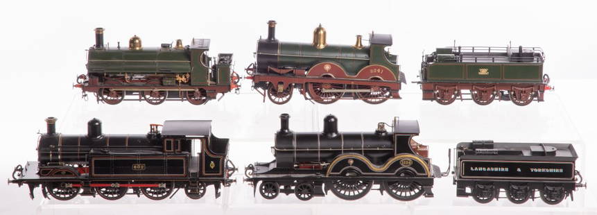
Sold2023Model Train O Scale Locomotive AssortmentModel Train O Scale Locomotive Assortment (6) items including an unlettered 2-2-2 Saddle tank, a 3232 class 2-4-0 Great Western Railways steam locomotive #3241, a 6-0-2 Taff Vale steam locomotive #602See Sold Price
Sold20232-Inch Live-Steam Model of the Steam Roller "Victoria", c. 19702-Inch Live-Steam Model of the Steam Roller "Victoria", c. 1970 Model of the 8-ton 'C' class roller built by Aveling & Porter Ltd of Rochester, Kent, coal-fired, with reversible two-gear transmission,See Sold Price
Sold2022Grand Trunk Railway System Map LithographCanadian. 1870s. Lithographed paper. Exhibits uniform toning and a series of tears and losses from the outer edges. Frame marked, "Grand Trunk Railway System".See Sold Price
6 days LeftJasper521898 Cram Map of Victoria [verso] South Australia and Northern Terr. [verso] Queensland -- Map of$40
10 hrs LeftThe Bidder AuctionsThe map of the railways in the Land of Israel - published by the Surveying Department of the British$30
BonhamsBAINES (THOMAS) Explorations in South-West Africa being an Account of a Journey in the years 186...£300
2 days LeftTrillium Antique Prints & Rare BooksGould, Australia - Red-backed Halcyon or Kingfisher$200
2 days LeftTrillium Antique Prints & Rare BooksWilkes - 6 View Engravings of New Zealand, Tonga, Fiji, &c.$100
2 days LeftTrillium Antique Prints & Rare BooksWilkes - 13 Native People Engravings (Portrait of Commanders including Wilkes, people from New$100


![1898 Cram Map of Victoria [verso] South Australia and Northern Terr. [verso] Queensland -- Map of (1 of 3)](https://p1.liveauctioneers.com/5584/331064/178466379_1_x.jpg?height=282&quality=70&version=1716924723)


![[First Australian novelist] Grimstone, Mary Leman (1 of 1)](https://p1.liveauctioneers.com/94/330664/178342107_1_x.jpg?height=282&quality=70&version=1716466933)


