Sold20201939 Nat Geo WWII Eve Map of Europe and theTitle/Content of Map: 1939 Nat Geo WWII Eve Map of Europe and the Mediterranean -- Central Europe and the Mediterranean as of September 1, 1939 Cartographer: National Geographic Society Year/Place: 19See Sold Price
Sold2022WWII AFF Cloth Maps (8) Charts with PouchVintage WWII AFF Silk Cloth Maps / Charts. Very clean with few stains. Measure approximately 22 in. x 24 in to 28 in. x 28 in. Includes: Nagashima, Nagasaki second ed. NI52; Number 20 Amboina, SouthweSee Sold Price
Sold2024Prewar Antique Silk Double Sided Map of Europe Germany France Belgium HollandPrewar Antique Silk Double Sided Map of Europe Germany France Belgium Holland. Measurements in inches: 29 x 28 1/2 Condition:Has browning along one edge on both sides of map Shipping:We offer in-houseSee Sold Price
Sold2018Vintage WWII Colliers War Map of Europe, 1942Title/Content of Map: Colliers War Map of Europe Date Printed: 1942 Cartographer: RAND MCNALLY & COMPANY Publisher: P. F. COLLIER & SON CORPORATION 1942 NEW YORK Size: Folio – 19.00 H x 25.75 W InchSee Sold Price
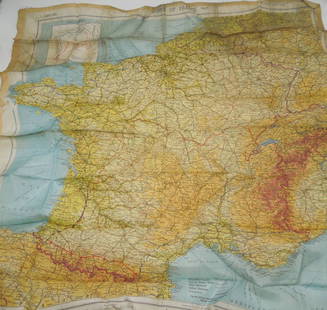
Sold2020Original WWII U.S. Army Silk Evasion MapsOriginal WWII U.S. Army Silk Evasion Maps - Offered Without Reserve - There is NO ESTIMATE on this item. - Vintage Original WWII U.S. Army Silk Evasion Maps for Aviators Depicting Central FranceSee Sold Price
Sold2019Group of Three WWII U.S. Pilot Escape Silk Maps, "Group of Three WWII U.S. Pilot Escape Silk Maps, " Amsterdam, Hamburg, Berlin, Warsaw on reverse Vilnyus, and Minsk," H. - 24 in., W. - 30 in.; " Stalingrad on reverse Stepnoy," H. - 22 in., W. - 20 iSee Sold Price
Sold2024TWO WORLD WAR II SILK ESCAPE MAPS. - Maps, 28 1/2 in. x 28 1/2 in. Pouch, 6 1/4 in. x 5 1/8 in.TWO WORLD WAR II SILK ESCAPE MAPS. Printed front and reverse with maps of European countries; includes maps "C/D" and "E/F" with original storage pouch.Issued to Special Operation Executive PersonnelSee Sold Price
Sold201911 Vintage Assorted World War II Maps of Europe11 Vintage Assorted World War II Maps of Europe from the 1940's, used condition, wear, worn.See Sold Price
Sold2023WORLD WAR II SILK AVIATORS ESCAPE MAPPROVENANCE: Owned and used by CIA agent A L Burridge who was a founding member of Civil Air Transport (CAT). General Claire Chenault started this CIA funded airline after Flying Tigers to fight mainlaSee Sold Price
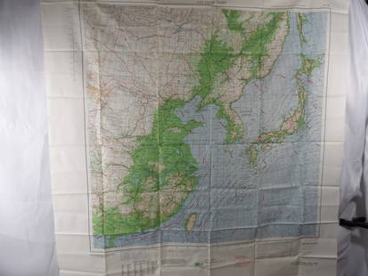
Sold20234 WWII Silk Pilots Escape or Invasion MapsGroup of 4 World War II era silk Air Force pilots escape maps, one of Sicily and Italy, Ryojun, Manchuria/Pei-P'Ing China, Otomari, Japan/Vladimiro-Aleksandrovskoye, Greece/Bulgaria-Romania 15" x 19"-See Sold Price
Sold2024Collection of Allied Military Silk Printed Maps, WWII Era and LaterCollection of Allied Military Silk Printed Maps, WWII Era and Later. These maps were employed during World War II and beyond to aid Allied soldiers in escaping enemy territory or POW camps, helping thSee Sold Price
Sold20202nd BN 417th Infantry 76 Div. WWII Colorful Cartoon Map2nd BN 417th Infantry 76 Div. WWII Colorful Cartoon map. US Soldiers in Europe. Has some slight discoloration but is in overall excellent condition. Measures approx. 22" tall x 29" wide. You aSee Sold Price
Sold2023WWII March 1944 Zones of France Silk Escape MapMarch 1944 Original silk escape map of France. This would be the type of item carried by US Paratroopers during the Invasion of Normandy, as well as US aviators flying missions over France.See Sold Price
Sold2021A World War II Air Ministry printed silk escape map ofA World War II Air Ministry printed silk escape map of Germany (issued for downed airmen and Prisoners of War), 36 x 45 cm, framed and glazedSee Sold Price
Sold2023WWII 1943 USAAF Army Air Force Silk Pilot Escape Officers Cloth Map of ChinaWWII 1943 AAF Southeast China Cloth Silk Officers Map. This map was part of the Asiatic Series. The approximate size is 20 x 27 inches. Excellent condition with tape residue and a chemical type smellSee Sold Price
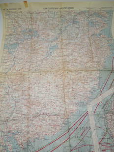
Sold2022Huge Group (45+) of World War II Era Maps of GreatHuge Group (45+) of World War II Era Maps of Great Britain, Europe & America A large group of topographical and aeronautical maps of America, Great Britain, and Europe from the Second World War. RSee Sold Price
Sold2023RARE WWII British Cloth Escape Maps European Theater 1943 Series #43 E/F.WWII British Cloth Escape Maps European Theater 1943 Series #43 E/F. This Silk map is in Excellent Condition as pictured. Side E has maps of Germany Protectorate, Slovakia, Poland, and Hungary while SSee Sold Price
Sold2023RARE WWII British Cloth Escape Maps European Theater 1943 Series #43 C/D.WWII British Cloth Escape Maps European Theater 1943 Series #43 C/D. This Silk map is in Excellent Condition as pictured. Side C has maps of Holland, Belgium, France and Germany while Side D has mapsSee Sold Price
Sold2023Eisenhower, Crusade in Europe, 1948, WWII Memoirs, illustrated, Maps"Crusade in Europe" by Dwight David Eisenhower, published by Doubleday, Garden City, New York, 1948. Hard boards, original brown cloth with lettering on front board and spine, 5.3/4" x 8.3/4"; endpapeSee Sold Price
Sold2023U.S. MILITARY WWII FIELD MAPS 1943-1944(5)170300 U.S. MILITARY WWII FIELD MAPS 1943-1944(5) U.S. military WWII field maps 1943-1944 to include one original Europe Road Map Series 1 first edition France with name of soldier Caldwell, two WWIISee Sold Price
Sold20211813 Embroidered Map of EuropeTitle: 1813 Embroidered Map of Europe Dimension: 20 3/4" x 24 1/4" framed. Materials: Silk on wool Additional Information: G. Smerdon Embroidered Map of Europe Probably Southern English dated 1813 CarSee Sold Price
Sold2020Antique Silk Embroidered Map Sampler, Circa 1804An antique with worldly allure, this art piece showcases a map of Europe circa 1804. This relic is outlined by an oval frame with a dark finish for a traditional look.24″w x 27.5″h x 1RSee Sold Price
Sold20245 U.S. fighter pilot East Asia escape cloth mapsHeading: (China - World War II escape map) Author: Title: Five US Army Air Force pilot silk escape maps of East Asia from World War II Place Published: Washington, D.C. Publisher:Army Map Service, U.See Sold Price
May 16Potter & Potter AuctionsGEESINK, Joop (1913 – 1984). Europa. 1957. Netherlands: KLM...$100
May 08C & T Auctioneers and Valuers LtdWW2 North West Europe 1944-45 No. 45 Royal Marines Commando Action Figure£30
4 days LeftPrime Auction Gallery, Inc.Iran, Tabriz Hand Knotted Silk Large Persian Rug 'Map Of Iran'$6,000
Featured2 days LeftJasper52Bismarck Archipelago New Guinea New Britain 1943/4. Ports. World War 2 1961 map$8
Featured1 day LeftJasper521792 Elwe Map of Southern Russia in Europe -- Partie Meridionale de Moscovie Dresse par G. De L'Isle$190