Sold2022Scarce 1st ed. Northern Texas/Indian Territory, Tunison 1885Beautiful and scarce double-page chromolithographic map of Northern Texas and Indian Territory. From the 1885 edition of Tunison’s Peerless Universal Atlas of the World. WorldCat lists this atlaSee Sold Price
Sold2021Very scarce Southern Texas, Cram 1882Scarce double-page hand-colored map of Southern Texas from the very early and scarce 1882 Cram’s Unrivaled Family Atlas of the World. All Cram atlases prior to 1883 are extremely scarce. They arSee Sold Price
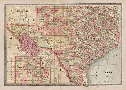
Sold2021Scarce Colton 2-page map of Texas, c1884Breathtakingly large, fully hand-colored vintage map of Texas from the very scarce 1890 edition of Colton’s General Atlas. This is the only edition of this atlas that I’ve ever seen—See Sold Price
Sold2022Scarce Texas map (western part) from Asher & AdamsLarge double-page map of Western Portion of Texas with inset of extreme western tip of the state. Shows towns, proposed railroad lines and river, including the Colorado River and the Rio Grande. The fSee Sold Price
Sold2021Scarce variant of Texas, George F. Cram 1883Title: Scarce variant of Texas, George F. Cram 1883 Description: Cerographic relief line engraving with county divisions in yellow and state boundaries outlined in rose. This double-page map is extremSee Sold Price
Sold2022Scarce 1844 U. S. map w/large Texas, western territoriesOne of the more interesting and elusive school maps of the United States at a time of great territorial expansion. This 1844 double-page Olney school geography map shows the Republic of Texas in one oSee Sold Price
Sold2022Scarce and impressive early Cram RR map of DakotaVery scarce double-page map of the Dakota Territory from the scarce 1882 edition of Cram’s Unrivaled Family Atlas of the World. The 1882 atlas was the last Cram atlas to feature hand coloring oSee Sold Price
Sold2022Scarce double-page RR map of the United States, 1872Unique and scarce version of this map with small section at the bottom of Montana labeled as “Part of Dakota.” This appears to be the only version of the map to contain this anomaly. AttraSee Sold Price
Sold2022Impressive and scarce engraved large map of CaliforniaExtremely scarce double-page vertical map of California. Fully hand colored in pastels with fine level of detail throughout. Shows railroads, wells, springs, towns, rivers, lakes, topography, deserts,See Sold Price
Sold2023Scarce and fine 1894 hand-colored RR map of FloridaScarce, distinctive double-page map of Florida from likely the last American atlas to feature hand-color on its maps. Good representation of the swampy areas in the southern portion of the state. InseSee Sold Price
Sold2022Scarce Railroad map of St. Louis by Geo. F. CramDetailed and scarce 1910 double-page map of St. Louis showing railway routes. Interestingly, it also locates every interurban route in the city, a most unusual addition. This map comes the extremely sSee Sold Price
Sold2022(TEXAS.) Joseph Hutchins Colton. New Map of the State of Texas Compiled from J. de Cordova's Large(TEXAS.) Joseph Hutchins Colton. New Map of the State of Texas Compiled from J. de Cordova's Large Map. Double-page lithographed map of Texas with attractive original hand-color by county. 18x27 incheSee Sold Price
Sold20221885 Two-page Railroad map of TexasCram’s 1885 double-page railroad map of Texas has exceptional printed color. Every railroad line in the state is highlighted in a heavier black line than such things as county borders, rivers anSee Sold Price
Sold2020CAREY, HENRY CHARLES; and LEA, ISAAC. Geographical,CAREY, HENRY CHARLES; and LEA, ISAAC. Geographical, Statistical, and Historical Map of Mexico. Double-page engraved map of Mexico, Texas, and parts of the southwestern United States with border panelsSee Sold Price
Sold2022(REPUBLIC OF TEXAS.) Alexander Keith Johnston. United States and Texas.(REPUBLIC OF TEXAS.) Alexander Keith Johnston. United States and Texas. Double-page engraved map of the eastern United States and an independent Texas. 21x25½ inches sheet size, wide margins; oriSee Sold Price
Sold20201786 map of N. America by de la PorteScarce and beautiful double-page early copperplate-engraved map of North America depicting the new country right after America claimed her independence. Early east coast states delineated along with pSee Sold Price
Sold2023Map of Northeastern Pennsylvania.Publication Date: 1884 Title: Map of Northeastern Pennsylvania. Cartographer: [RAND, MCNALLY & CO.] Publisher: H.H. HARDESTY & CO. Height: 12.75 Width: 20 Double-page map from a scarce Hardesty atlas.See Sold Price
Sold2023Civil War era 1863 map of Mexico & Caribbean nationsLovely and vintage double-page map showing all of Mexico, Central America, Texas, Indian Territory and states of the Deep South during the middle of the American Civil War. Map has an 1860 copyright bSee Sold Price
Sold2021Map of NY City from very scarce Colton atlasTitle: Map of NY City from very scarce Colton atlas Date: Map dated 1886 Description: Interesting map of NYC and vicinity, oriented with North at the top (most other double page maps of New York fromSee Sold Price
Sold2023Scarce 1st ed. Tunison’s California, Oregon, Nevada, 1885Beautiful double-page map of California and western states, from the 1885 Tunison’s Peerles Universal Atlas of the World by H. C. Tunison. WorldCat lists this atlas as Tunison’s first atlaSee Sold Price
Sold2022Scarce railroad map of Oklahoma/Indian Territory, 1897Wonderfully preserved, large double-page map of Oklahoma during the frontier period when half of the present-day state was still called “Indian Territory.” This authentic vintage map comes from thSee Sold Price
Sold2023RR map of New Mexico from scarce 1898 Cram’s Atlas.Large and dramatic double-page map of New Mexico naming and showing all rail lines in the state. Every railroad line is named, numbered, and color-coded by a legend on the map. From the very scarce CrSee Sold Price
Sold2023RR map of Arizona from scarce 1898 Cram’s Atlas.Large and dramatic double-page map of Arizona naming and showing all rail lines in the state. Every railroad line is named, numbered, and color-coded by a legend on the map. From the very scarce Cram�See Sold Price
Sold2022Scarce Johnson's Missouri & Kansas map during CivilLarge double-page map of these two states of great importance during the Civil War. One of Johnson and Ward’s more decorative issues, this map offers a fascinating snapshot of these two hotly cSee Sold Price
May 04BucklinVarious; Orienetation for the Pacific Theater [RARE 1945 US WAR DEPARTMENT PAMPHLET WWII PROPAGANDA]$50(1 bid)
May 09Hunt and Peck Estate Services, Inc.1713 Tho. Brodrick "A Compleat history of the late war in the netherlands$50
5 days LeftJasper521875 Warner & Beers United States Railroad Map -- Railroad Map of the United States$140
Featured5 days LeftJasper521792 Elwe Map of Southern Russia in Europe -- Partie Meridionale de Moscovie Dresse par G. De L'Isle$190
5 days LeftJasper521645 Jansson Map of Portugal and Parts of Spain -- Portugallia et Algarbia quae olim Lusitania$200
5 days LeftJasper521640 Blaeu/Pijnacker Map of Northern Netherlands -- Drentia Comitatus. Transiselaniae Tabula II$240
5 days LeftJasper521707 Schenk Dutch Provinces Chart with Leo Belgicus Map -- Tafel vande XVII Nederlandze Provincien,$240
May 04BucklinDando, Walter; Wild Animals and the Camera [1909 1ST EDITION - Peter Beard interest]$50(1 bid)
5 days LeftAdam's AuctioneersH.C CAREY AND I.LEA (publishers) A Complete Historical, Chronological and Geographical AMERICAN€1,500
2 days LeftTrillium Antique Prints & Rare BooksBlaeu's Tooneel des Aerdrycx - Fifth Volume with 55 Engraved Maps$1,950(1 bid)


![Map of Northeastern Pennsylvania.: Publication Date: 1884 Title: Map of Northeastern Pennsylvania. Cartographer: [RAND, MCNALLY & CO.] Publisher: H.H. HARDESTY & CO. Height: 12.75 Width: 20 Double-page map from a scarce Hardesty atlas.](https://p1.liveauctioneers.com/5584/285598/150695091_1_x.jpg?height=310&quality=70&version=1681855790)


![Various; Orienetation for the Pacific Theater [RARE 1945 US WAR DEPARTMENT PAMPHLET WWII PROPAGANDA] (1 of 4)](https://p1.liveauctioneers.com/8658/325945/175540885_1_x.jpg?height=282&quality=70&version=1712964944)


![[Maps] American Atlas, Folio (1 of 14)](https://p1.liveauctioneers.com/3532/326332/175680379_1_x.jpg?height=282&quality=70&version=1713151485)

![Dando, Walter; Wild Animals and the Camera [1909 1ST EDITION - Peter Beard interest] (1 of 9)](https://p1.liveauctioneers.com/8658/325945/175541717_1_x.jpg?height=282&quality=70&version=1712964944)


