Sold20211786 Jefferys Map of Canadian Maritime Provences and USTitle: 1786 Jefferys Map of Canadian Maritime Provences and US New England -- A New Map of Nova Scotia, and Cape Breton Island with the Adjacent Parts of New England and Canada Cartographer: T JefferySee Sold Price
Sold20211756 Seutter/Lotter Map of Canadian Maritime ProvincesTitle: 1756 Seutter/Lotter Map of Canadian Maritime Provinces and Maine -- Partie Orientale de la Nouvelle France ou du Canada avec l'Isle de Terre-Neuve et de Nouvelle Ecosse, Acadie et Nouv. AngleteSee Sold Price
Sold20201780 - Antique map of Canadian Maritime Provinces. 1780Title/Content of Map: 1780 - Antique map of Canadian Maritime Provinces. 1780 Cartographer: Rigobert Bonne Date Printed: 1780 Description: Colonial Northeastern United States & Canada. Rigobert Bonne,See Sold Price
Sold20191876 Mitchell Map of Canadian Maritime Provinces --Title/Content of Map: 1876 Mitchell Map of Canadian Maritime Provinces -- County Map of Nova Scotia, New Brunswick, Cape Breton Id. and Prince Edward's Id. Date: 1876 Philadelphia Cartographer: S MitcSee Sold Price
Sold20161940’s-1960’s Canadian & U.S. Road MapsLot of 19 assorted 1940’s-1960’s Canadian & U.S. recreational, sightseeing & state highway system maps includes: Alabama highway, Pennsylvania highway, Maine highway, New Jersey highway, New YorkSee Sold Price
Sold2017Mitchell: Map of North America, 1848North America, S. Augustus Mitchell, 1848. 13 x 15.75 inches. Great transitional map showing political boundaries within that short time period after the Canadian/U.S. boundary settlement and before tSee Sold Price
Sold2019Mitchell: Canadian Maritime Provinces with HalifaxMap Title: County Map of Nova Scotia New Brunswick Cape Breton Id. and Pr. Edward's Id. Cartographer: S. A. Mitchell Place / Date: Philadelphia / 1870 Size: 10 5/8" x 13 3/8" Condition: wash color; ovSee Sold Price
Sold2024Eleven Army Corps of Engineers Port Series No. 1 Through No. 8 Books with Fold Out MapsA group of Port Series books by the War Department US Army Corps of Engineers and Maritime Commission spanning 1928 to 1938, missing No. 4 in the series. Includes No. 1 Port of Portland Maine, No. 2 PSee Sold Price
Sold2024Eleven Port Series Books with Fold Out Maps - No. 9 Through No. 23 - Army Corps of EngineersA group of Port Series books by the War Department US Army Corps of Engineers and Maritime Commission spanning 1932 to 1940. Includes No. 9 Port of Charleston S.C., No. 10 Ports of Savannah and BrunswSee Sold Price
Sold20151845 MITCHELL'S REFERENCE & DISTANCE WALL MAP U.S.SHOWING MITCHELL'S 1845 REFERENCE AND DISTANCE WALL MAP OF THE UNITED STATES WITH GENERAL MAP OF THE US WITH CONTIGUOUS BRITISH AND MEXICAN POSSESSIONS.PHILADELPHIA : S. AUGUSTUS MITCHELL COPPER-ENGRASee Sold Price
Sold2024Thomas Jefferys - Map of Hungary with Turky in Europe [shows Cyprus]Hand-coloured decorative map of Hungary, Greece, Turkey, Cyprus, and the Gulf of Venice, showing provinces, towns, islands, rivers, etc. Thomas Jefferys (ca. 1719-1771) was a prolific map publisher, eSee Sold Price
Sold2017DIDIER ROBERT DE VAUGONDY (FRENCH, 1723-1786) MAP OFDIDIER ROBERT DE VAUGONDY (FRENCH, 1723-1786) MAP OF VIRGINIA AND MARYLAND hand-colored engraving on laid paper, "Carte De La Virginie, Et Du Maryland", from De Vaugondy's "Atlas Universel", publishedSee Sold Price
Sold2017DIDIER ROBERT DE VAUGONDY (FRENCH, 1723-1786) MAP OFDIDIER ROBERT DE VAUGONDY (FRENCH, 1723-1786) MAP OF EASTERN AMERICA AND THE OHIO RIVER VALLEY hand-colored engraving on laid paper, "Partie De L'Amerique Septentrionale qui comprend Le Cours De L'OhiSee Sold Price
Sold2017William Faden 1796 Map Eastern US, North AmericaFaden, William (BRITISH, 1749-1836); Map of the Eastern United States, North American with British Territories and Those of Spain according to the Treaty of 1784 (from a larger atlas), 1796; handcolorSee Sold Price
Sold2020Map of U.S., 1846*** START PRICE IS THE RESERVE *** [America] HAVEN & EMMERSON. Map of the United States and Mexico Including Oregon, Texas and the Californias. Engraved map with original hand color. New York, 1846. 1See Sold Price
Sold2017French and Indian War, Thomas Jefferys' Broadside MapJefferys, Thomas. North America From the French of Mr D'Anville Improved with the Back Settlements of Virginia and Course of Ohio Illustrated with Geographical and Historical Remarks. London: 1755. CoSee Sold Price
Sold20221856 Colton Map of Canadian Maritimes and FishingTitle: 1856 Colton Map of Canadian Maritimes and Fishing Rights -- Colton's New Brunswick, Nova Scotia, Newfoundland and Prince Edward Id. Cartographer: GW and CB Colton Year / Place: 1856, New York MSee Sold Price
Sold2019MAPS - Maine. U.S. Gov.Maine. U.S. Gov., [Lot of 2] Map of the Northern Part of the State of Maine and of the Adjacent British Provinces... [and] Extract from a Map of the British and French Dominions in North America, 1838See Sold Price
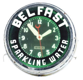
Sold2022WORKING BELFAST SPARKLING WATER ADVERTISING CLOCK.Early Belfast Sparkling Water clock with label that reads "Glo-Dial Clock Co. / Los Angeles, Calif.". Canadian and US patents are present. Overall scattered wear on outer ring of chrome part of clock,See Sold Price
Sold2022HAMILTON MARINE CHRONOMETER.The Chronometer is one of 800 made for the U.S. Maritime Commission. It is model 21 with 14 jewels by the Hamilton Watch Company. It has an uncut bimetallic balance wheel and an Elanor hairspring andSee Sold Price
Sold2020Mitchell Map of Western U.S.*** START PRICE IS THE RESERVE *** [America] MITCHELL, Samuel Augustus (1792-1868). A New Map of Texas, Oregon and California with the Regions Adjoining. Engraving with original hand color, with origiSee Sold Price
Sold2021Great 1860s map of the Maritime Provinces by MitchellTitle: Great 1860s map of the Maritime Provinces by Mitchell Description: This beautiful and detailed historical map depicts the Maritime Provinces (Nova Scotia, New Brunswick and Prince Edward’s IsSee Sold Price
Sold2020Henricus Hondius 1650 Map of America(Amsterdam, 1597-1651) Very nicely detailed hand colored map of the US of the period predating that of Petrus Schenk. The piece has exceptional colors and has been professionally framed and acid freeSee Sold Price
Sold2022New Brunswick, Nova Scotia, Newfoundland, etc. - 1863Wonderful large and vintage map of Canada’s Maritime Provinces just a couple of years before the confederation of Canada. The map identifies forts, rivers, mountain passes, coastal features, toSee Sold Price
4 hrs LeftJasper521852 Owen Geological Maps of the Pigeon River Minnesota -- (1) Geological Map Coast View and Section$45
Jun 13Swann Auction Galleries(CANADA.) Thomas Jefferys. A Large and Particular Plan of Shegnekto Bay, and the Circumjacent$1,100
Jul 07A-1 AuctionBarry Stein Oregon Artist Bronze Sculpture "The Last Samurai" Japanese Warrior 4/90 Casting$250(5 bids)
4 days LeftEarly American History Auctions1776 Map, PARTIE ORIENTALE DU CANADA, AVEC LA NOUVELLE ANGLETERRE, L'ACADIE... by P. Santini, Framed$950
3 days LeftFreeman's | HindmanHUGHES, Griffith. The Natural History of Barbados. 1750. FIRST EDITION.$1,000
Jun 13Schultz AuctioneersMixed group of U.S. Large $2 notes, Canada nickels, coin guide books and more$225(3 bids)
Jun 13Swann Auction Galleries(CANADA.) Jonathan Carver. A New Map of the Province of Quebec, According to the Royal Proclamation$450
Jun 23Schilb Antiquarian Rare Books1877 Geology Geography Surveys 1ed Nevada Wyoming Utah George Wheeler US West 2v$1
Jun 13Schultz AuctioneersMixed lot U.s. and foreign stamps including Pan Am, Canada and Penny Black$75(2 bids)
2 days LeftAkiba GalleriesAntique Mast, Crowell, & Kirkpatrick Map Of Texas, California, & Nevada$25(1 bid)
4 hrs LeftJasper521857 Emory Maps of Magnetic Declanation Lines and Sections along the US Mexican Border -- United$45


![Thomas Jefferys - Map of Hungary with Turky in Europe [shows Cyprus]: Hand-coloured decorative map of Hungary, Greece, Turkey, Cyprus, and the Gulf of Venice, showing provinces, towns, islands, rivers, etc. Thomas Jefferys (ca. 1719-1771) was a prolific map publisher, e](https://p1.liveauctioneers.com/8353/325198/175261422_1_x.jpg?height=310&quality=70&version=1712598926)


![Map of U.S., 1846: *** START PRICE IS THE RESERVE *** [America] HAVEN & EMMERSON. Map of the United States and Mexico Including Oregon, Texas and the Californias. Engraved map with original hand color. New York, 1846. 1](https://p1.liveauctioneers.com/1968/163248/82424576_1_x.jpg?height=310&quality=70&version=1583340284)


![MAPS - Maine. U.S. Gov.: Maine. U.S. Gov., [Lot of 2] Map of the Northern Part of the State of Maine and of the Adjacent British Provinces... [and] Extract from a Map of the British and French Dominions in North America, 1838](https://p1.liveauctioneers.com/6576/142214/71976779_1_x.jpg?height=310&quality=70&version=1557929467)

![Mitchell Map of Western U.S.: *** START PRICE IS THE RESERVE *** [America] MITCHELL, Samuel Augustus (1792-1868). A New Map of Texas, Oregon and California with the Regions Adjoining. Engraving with original hand color, with origi](https://p1.liveauctioneers.com/1968/163248/82424595_1_x.jpg?height=310&quality=70&version=1583340284)


![Western US Map, 1857 [181625] (1 of 3)](https://p1.liveauctioneers.com/2699/331495/178785798_1_x.jpg?height=282&quality=70&version=1717094933)


