Sold2021New Hanover county North Carolina mapNew Hanover county North Carolina state highway commission map, US Department of commerce Bureau of public roads statewide highway planning survey from January 1, 1961, size, 19“ x 32“ in very gooSee Sold Price
Sold2022Road Atlases, Maps, Books With Mineral AreasIncluded are maps and books of geology and mineral resources in North Carolina, AAA road maps of Colorado and Wyoming, two road atlases for Baltimore County and New Hampshire. Some areas are denoted aSee Sold Price
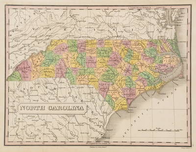
Sold2019Eight (8) Augustus Mitchell MapsCollection of eight maps including New Jersey/Maryland Delaware 1872, Two north and South Carolina 1872 maps (15" x 12"), Minnesota 1890 , Florida and the Carolinas 1860, County map of the state of ArSee Sold Price
Sold2017Johnson: Map of North & South Carolina, 1864Map: 1864 Johnson Map of North and South Carolina Maker: Johnson and Ward Published: 1864, New York Size: 17.3 X 23.8 in. Excellent and highly detailed map of the Carolinas, showing the counties colorSee Sold Price
Sold2021Pender County North Carolina mapPender County North Carolina state highway commission map, US Department of commerce Bureau of public roads state wide highway planning survey from January 1, 1961, size is 19“ x 31“ in very goodSee Sold Price
Sold2022SECURITY GUARD BADGES - LOT OF 5SECURITY GUARD BADGES - LOT OF 5 Lot of five obsolete Security Guard badges, includes: New Hanover, North Carolina Memorial Security Sergeant badge. New Jersey Magnetic Metals Security cap badge numSee Sold Price
Sold2022LOUIS ORR, ORTON PLANTATION HOUSE, NC ETCHINGLouis Orr (American/Paris, 1879-1964). "Orton Plantation House, New Brunswick County, North Carolina", etching from the "North Carolina" series. Pencil signed and titled. Framed. Note: Proceeds of thiSee Sold Price
Sold20231860 Mitchell Map of Florida, South and North Carolina -- County Map of Florida on page with Map ofTitle: 1860 Mitchell Map of Florida, South and North Carolina -- County Map of Florida on page with Map of South Carolina, on page with County Map of North Carolina Cartographer: S Mitchell Year / PlaSee Sold Price
Sold2023Anthony Finley North Carolina Counties MapA Anthony Finley (American, 1784-1834) handcolored engraving depicting the counties within North Carolina and the surrounding areas. Stamped 'Published By A. Finley Phliad.' lower center. Presented inSee Sold Price
Sold20201860 Mitchell Map of Florida, South and North CarolinaTitle/Content of Map: 1860 Mitchell Map of Florida, South and North Carolina -- County Map of Florida on page with Map of South Carolina, on page with County Map of North Carolina Cartographer: S MitcSee Sold Price
Sold20211860 Mitchell Map of Florida, South and North CarolinaTitle: 1860 Mitchell Map of Florida, South and North Carolina -- County Map of Florida on page with Map of South Carolina, on page with County Map of North Carolina Cartographer: S Mitchell Year / PlaSee Sold Price
Sold20181863 Mitchell Map of Florida, South and North CarolinaTitle/Content of Map: 1863 Mitchell Map of Florida, South and North Carolina -- County Map of Florida on page with Map of South Carolina, on page with County Map of North Carolina Date: 1863, PhiladelSee Sold Price
Sold20181860 Mitchell Map of Florida, South and North CarolinaTitle/Content of Map: 1860 Mitchell Map of Florida, South and North Carolina -- County Map of Florida on page with Map of South Carolina, on page with County Map of North Carolina Date Printed: 1860,See Sold Price
Sold20201860 Mitchell Map of Florida, South and North CarolinaTitle/Content of Map: 1860 Mitchell Map of Florida, South and North Carolina -- County Map of Florida on page with Map of South Carolina, on page with County Map of North Carolina Date: 1860, PhiladelSee Sold Price
Sold20231858 Mitchell Map of New York to North Carolina -- No. 11 Map of the Middle States and Part of theTitle: 1858 Mitchell Map of New York to North Carolina -- No. 11 Map of the Middle States and Part of the Southern… Cartographer: S Mitchell Year / Place: 1858, Philadelphia Map Dimension (in.):See Sold Price
Sold20181839 Mitchell Map of New York to North Carolina -- No.Title/Content of Map: 1839 Mitchell Map of New York to North Carolina -- No. 11 Map of the Middle States and Part of Southern… Date: 1839 Philadelphia Cartographer: S Mitchell Size: 16.8 x 10.4 in.See Sold Price
Sold2018Mitchell: Antique Map of New York to North CarolinaTitle/Content of Map: 1852 Mitchell Map of New York to North Carolina -- No. 11 Map of the Middle States and Part of Southern… Date Printed: 1852 Philadelphia Cartographer: S Mitchell / CowperthwaitSee Sold Price
Sold2018Two Civil War Era Mitchell MapsMap of North America Showing Its Political Divisions and county maps of North Carolina, South Carolina, and Florida on one sheet (Philadelphia: S. Augustus Mitchell, 1860). Not framed. 15.25 x 12.25 iSee Sold Price
Sold20231855 Cowperthwait map of North CarolinaA New Map of North Carolina with its Canals, Roads & Distances from Place to Place along the Stage & Steam Boat Routes. Shows and highlights railroad routes, towns, rivers, topography, roads, mountainSee Sold Price
Sold20211884 North Carolina MapAuthor: Cram Title: 1884 North Carolina Map Medium: Ink on Paper Dimensions: 14"X11" Rail Road and county Map of North Carolina dated 1884. Printed and published by George Cram in Chicago. Part of hisSee Sold Price
Sold2018A Set of Six Royal Crown Derby Cups and SucersImari pattern, #1128. Cup 2.5 in. Descent of the Sauter, Loree and Van Houten families of Somerset County, New Jersey and Chapel Hill, North Carolina. Additional high-resolution photos are available aSee Sold Price
Sold2022Three 18th Century North Carolina Mapsengravings on laid paper, all unframed, including: John Reid, The State of North Carolina From the Best Authorities, engraver Benjamin Tanner, New York, circa 1796, sheet 16-1/2 x 19 in.; Matthew CareSee Sold Price
Sold2020Rand, McNally & Co.'S New Business Atlas Map of NorthTitle/Content of Map: Rand, McNally & Co.'S New Business Atlas Map of North Carolina. Cartographer: RAND, MCNALLY & CO. Date: 1900 Publisher: RAND, MCNALLY & CO. Size: 18.75Height - 26Width Page 121-1See Sold Price
Sold20181867 Mitchell Map of North and South Carolina -- CountyTitle/Content of Map: 1867 Mitchell Map of North and South Carolina -- County Map of North and South Carolina Date: 1867, Philadelphia Cartographer: S Mitchell Size: 11.5 x 13.8 in. This is a handsomeSee Sold Price
Jun 13Swann Auction Galleries(COLONIAL NORTH AMERICA.) Group of 6 eighteenth-century engraved British periodical maps.$900
7 days LeftJasper521880 Map of US Tobacco Production by Type of Tobacco -- Map of the United States Showing the Regions$45